All Activity
- Past hour
-
Not sure I like the ICON at 78hrs. Northern and southern streams appear further apart. PV nudged west and closer to the northern stream piece and may serve to squash things later down the line. We'll see.
-
That CPC had no heavy snowfall threats on its 3-7 day hazards outlook suggestes that the CPC also believes the latter system poses a greater winter weather risk.
-

January 2026 regional war/obs/disco thread
brooklynwx99 replied to Baroclinic Zone's topic in New England
absolutely, allows that NS piece over the Lakes to come in at a good angle... that's why the GFS is as amped as it is -

January 2026 regional war/obs/disco thread
Typhoon Tip replied to Baroclinic Zone's topic in New England
Also useful to point out that the bulging into Manitoba is really critical there. That axial location near Frisco is traditionally too far west, but the idiosyncrasy of that arm rotating S on the heals of the 'Lakes trough is completing the wave space's couplet ...which transitively is favorable for maintaining amplitude that far E of the "real" ridge axis. Synoptic interpretation is a lot harder than folks realize. Just seeing where ridges and troughs are isn't the half of it. -
Selfishly, I'm more interested in the one closest in time currently. There looks to be a lot of energy with that system and a decent shot to overperform for someone from the east TN/southern apps part of our region. What catches my eye about this one is the GFS (normally our progressive model) is the one that closes off at 500, slowing the flow and popping a lee side low, while the Euro briefly closes off in the Ohio Valley, but quickly opens back up and scoots harmlessly out to sea. The initial system aside, I think the follower has the potential to be a big system. If you cycle through 500, the piece of energy around day 6 as shown on the 12z GFS comes in much further west through western Montana. Interestingly, even though at the surface it was a smoke show for the entire midsouth, it could have been even bigger if the piece from the four corners had gotten out in front of the energy diving south through the Dakotas (shown above) allowing for a phase. It's this piece in the four corners that detaches from the flow that @Carvers Gap notes as something to watch around the 20-21st. The Euro is much different in the evolution regarding the follower. Lots will change in the next couple of days, but even the Euro while saying no shows quite a bit of "potential".
-
Hopefully the Euro is wrong,its still showing the MJO in the WP and with some strong blocking into Siberia but its shows a Asian winter time monsoonal flow,rhis would be a waste with the blocking into Siberia it shows in our parts
.png.d8b785a36a14e09b2925943305947b48.png)
-
It might be better to have this thread as a period of interest between the 15th and the 18th
-
Currently: Light rain. 34.5°
-

Central PA Winter 25/26 Discussion and Obs
pasnownut replied to MAG5035's topic in Upstate New York/Pennsylvania
?? Whats the 26th? -

January 2026 regional war/obs/disco thread
tamarack replied to Baroclinic Zone's topic in New England
7/3/66 takes (bakes?) the cake. The coil thermometer at the end of the counter, 10-12 feet from the grill, reached about 140 - scale only reached 120 and the needle was well beyond that line. I'm better off NOT knowing how hot it next to the grill. In 1977 I could climb down to the 1st floor in 20 seconds. In 1966 I was behind the counter all day. Closing time was 8 PM but people were still pouring in 15 minutes later, so I went on the loudspeaker to say we were closed but would serve all who were already inside the lodge. (Got a bit of flack from the park supervisor but he soon understood.) At that time, I'd never had a cup of hot coffee despite brewing the stuff in the 50-cup urn. Ice tea demand went up and down with the temp; coffee demand went up and down by how many people came thru the gate. Could not understand then but later learned the joy of hot coffee in all weather. -
January 2026 regional war/obs/disco thread
brooklynwx99 replied to Baroclinic Zone's topic in New England
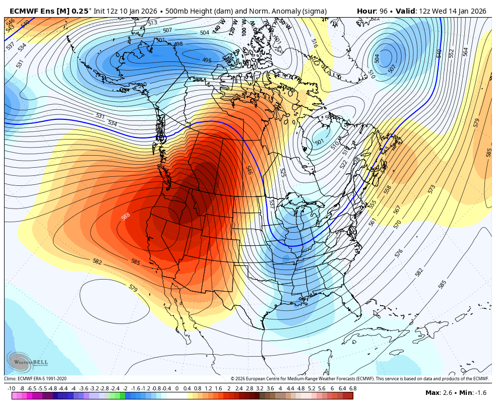
the +PNA ridge in and of itself argues for a coastal... that's 2.5 sigma over ID, nearly ideal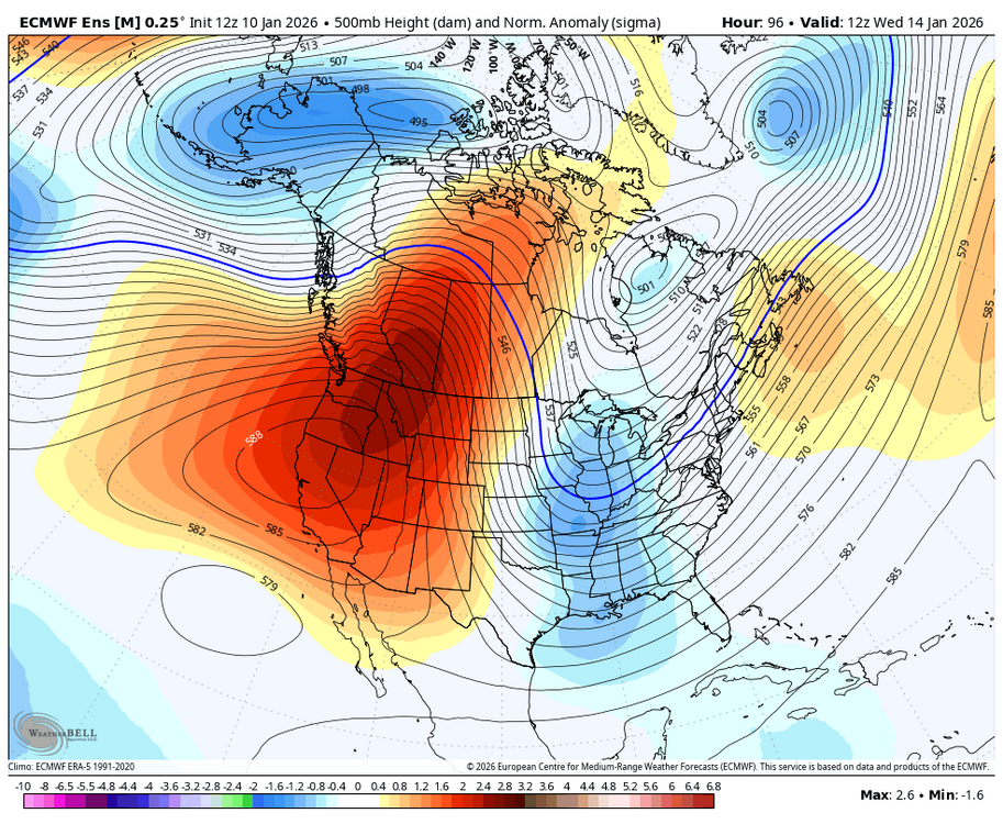
-

Central PA Winter 25/26 Discussion and Obs
Ruin replied to MAG5035's topic in Upstate New York/Pennsylvania
the 26th? lol um yeah book mark this watch it be like 50 and sunny lol. -
1.15" so far. A soaker.
-

January 2026 regional war/obs/disco thread
weathafella replied to Baroclinic Zone's topic in New England
More than slightly. 40s for you are +10 for a high. But certainly well below January thaw levels which when I conjure in my mind I think 55+ -
Typical lol
-

January 2026 regional war/obs/disco thread
Damage In Tolland replied to Baroclinic Zone's topic in New England
Def escaped torch everywhere in the northeast . Just a week of slightly AN -
So, maybe an "anchor" makes more sense, as it keeps the bottom of the trough from "getting away" and tilting negative. Can we throw another complete misnomer onto the pile?
-
Posts on ne.weather?
-

January 2026 regional war/obs/disco thread
mahk_webstah replied to Baroclinic Zone's topic in New England
The conversation is manageable now in the main thread, but I think we actually should start a storm thread tomorrow if it still looks like a viable threat between the 15th and 19th. This would separate the discussion into what might be happening in the short term and then also in the post January 20 period which is interesting in itself -
its winter; there is always a slight risk of heavy snow.
-
.7" already. good event. 44F and chicken soup in the stock pot.
-

January 2026 regional war/obs/disco thread
Baroclinic Zone replied to Baroclinic Zone's topic in New England
Don’t matter when the high or low occurs, still goes in the books for the day. -
Wiz must be in heaven . Bruins with two hat tricks. First time since 1964.
-
I mean really just minor adjustments to these H5 maps and its a Big Dog.
-
Not yet