All Activity
- Past hour
-

2025-2026 ENSO
michsnowfreak replied to 40/70 Benchmark's topic in Weather Forecasting and Discussion
Highs in the 50s/lows in the 40s dominate the week here. Going to the Tigers game Friday, definitely hoodie weather. Should warm into the weekend to 60s/40s but no heat in sight. -
wow I'm shocked 2010-11 and 2013-14 aren't on the coldest list, as they were pretty cold too. 2014-15 I understand because December to mid January was mild. 1995-96 had that three week thaw in January. 2002-03 was cold but more snowy than cold. Going back to the 80s, I would have thought 1981-82 should be on there as it was an extremely cold winter that lasted into April!
-
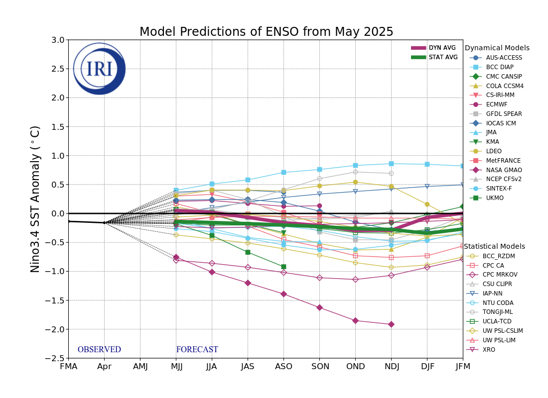
Tomorrow will see temperatures top out in the upper 60s as clouds increase. It will turn noticeably cooler for the remainder of the week. The below normal temperatures could persist into early next week. A general 0.50"-1.50" rainfall is likely Wednesday into Thursday. A gusty wind will likely accompany the rainfall. Showers could persist into Friday. There is a chance that New York City could see the mercury dip below 50° for the first time this month Thursday or Friday. The ENSO Region 1+2 anomaly was 0.0°C and the Region 3.4 anomaly was +0.1°C for the week centered around May 7. For the past six weeks, the ENSO Region 1+2 anomaly has averaged +0.55°C and the ENSO Region 3.4 anomaly has averaged -0.07°C. Neutral ENSO conditions will likely continue through at least mid summer. Early indications are that summer 2025 will be warmer than normal in the New York City and Philadelphia areas. The potential exists for a much warmer than normal summer (more than 1° above normal). The SOI was -0.44 yesterday. The preliminary Arctic Oscillation (AO) was -0.435 today. Based on sensitivity analysis applied to the latest guidance, there is an implied near 50% probability that New York City will have a warmer than normal May (1991-2020 normal). May will likely finish with a mean temperature near 63.2° (near normal).
-
as long as the sun is out it will hit 70 here for Memorial Day. The cold weather will come this week with the rain and be out of here by the weekend.
-
That sucks. My condolences...
-
tell it to anyone out on the sound or raritan bay, if they are crazy enough.....
-
and just after i planted my crops....for a few years i held off til jun 1st, but got suckered this year with some warmer weather. peppers and eggplants do not recover from that kind of cold. the nurseries and big box stores just keep selling the same people the same type of seedlings as the previously purchased ones die off....and yet my broccoli bolted early because it got hot for a few days.
-
OTAs?
-
43.8F Light rain. Not bad for 5pm 5/19
-
 Camir81 joined the community
 -
Yeah today blew long thick dongs. Never could fully shake clouds. Thankfully heading to Dallas early morning until late week so avoid hell on Earth and back to enjoy a much nicer weekend
- Today
-
My wag from a couple weeks ago was that we needed about 200% of normal rain for May and June to prevent a dust bowl summer. Seems well on the way to do that for May at least.
-
Models are often overdone on winds....
-

-
Detroit Free Press

-
Looks like the enhanced area expanded again. Still mentions super cells and strong tornadoes, with two rounds of storms.
-
48° and the wind is howling
-
Based on the marine forecast Utpton doesn’t seem that enthusiastic. Max winds 35 knots. The difference between 35 and 45 knots is substantial on the resulting seas. That will have a large impact on wether the jones beach air show can run.
-
Wed-Thu: Looks somewhat interesting as GEFS seems to have cluster of closed 5H low near e LI. 50MPH wind gusts and 2" rain possible LI area, esp Thursday. We'll see. No thread since some ensembles are weaker and recent dryness has low flows there and high FFG, except nw NJ which may be vulnerable??? Check again tomorrow.
-
Coc’d.
-
Lucking out down here, high of 70 so far with 90% sunshine, wind is refreshing but annoying
-
i almost wonder if summers will continue to dim over eastern n/a ... and winters will continue to warm ...until there is no seasonal change.

-

2025-2026 ENSO
PhiEaglesfan712 replied to 40/70 Benchmark's topic in Weather Forecasting and Discussion


-
It's a matter of 'relative magnitude' You'd have to look at just the min departures from norm. then look at just the max departures from norm. Which ever has the greatest SD wins ... In this case we already know. The lows, particularly spanning the last couple of decades as Brian mentioned, have been increasing more so than the highs. He cites clouds and precip and I can't argue that. Ultimately, high temp is a response to solar diurnal flux so... if that flux is essentially the same - which it is ... - that leads to Terrain factorization as the modulating force. It's not voodoo. ha it's probably clouds but ...I'd just maybe add to that, increased aerosol pollution and the fact that we have a whole continent upstream delivering both industrial and bio generated farts to the New England rectum upon exiting so we may have additional part per in that discussion - just supposition...
-
There will be for sure. This kind of goes back to what I was talking about also. Yes, this week into the weekend will definitely have below average temperatures but the type of weather coming up is far from unusual for late May/Memorial Day Weekend. There's been many times when Memorial Day Weekend is chilly. I even feel like there might be more that are what you would call chilly than warm. However, most people that don't pay attention to the weather are not going to remember that. They'll remember the ones that had highs in the 80s each day and forget about all of the ones that had highs in the 50s or 60s. Then they'll say how they can't believe how cold it is and they never remember it ever being this cold for the holiday.
-
This would be very acceptable. A soaking rain that's not too light or too heavy would do wonders for vegetation. We've really greened up over a lot of the region due to the past few weeks. This would help further. Additional periods to monitor will be Tue/Wed next week and next weekend for more rain. We need to take every drop we can before the summer sets in.