All Activity
- Past hour
-
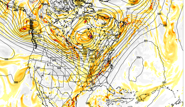
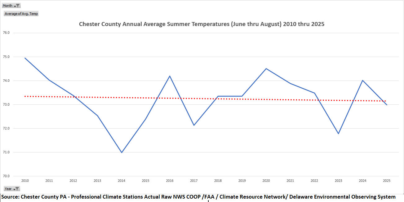
(002).thumb.png.6e3d9d46bca5fe41aab7a74871dd8af8.png) Are we already in our next cooling climate cycle for summer? Since 2010 summers now show a cooling trend!
Are we already in our next cooling climate cycle for summer? Since 2010 summers now show a cooling trend!
-
Is still think there's a chance that the trough is too progressive in some of these guidance, and that a slower/attenuated total mass results in more EC parallel/quasi parallel flow - i.e., a bit of a Bahama Blue. Admittedly, that is not what this is, ... but it's not far from it considering this frame is about 60 hours in and the trough is still W of 90. My speculations won't be hurt if it doesn't realize just sayn'
-
Saving this one for winter
-
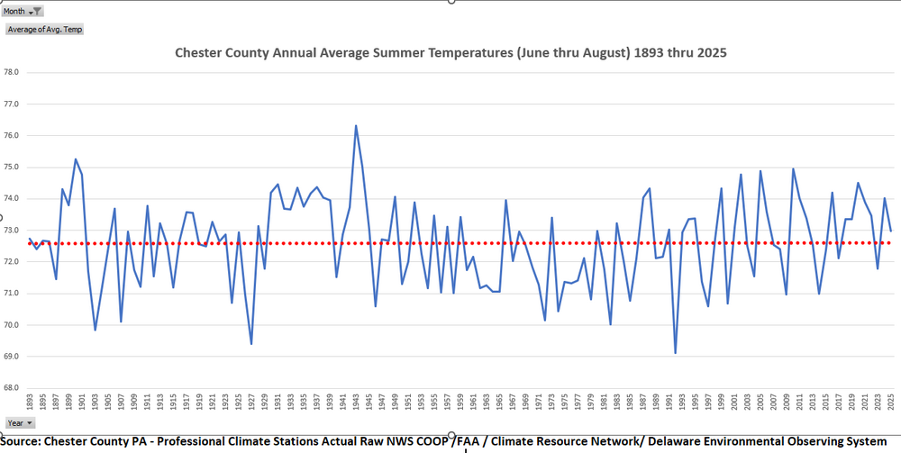
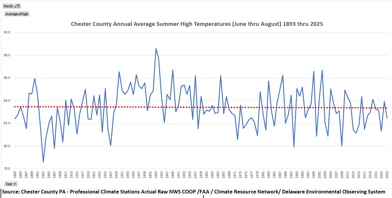
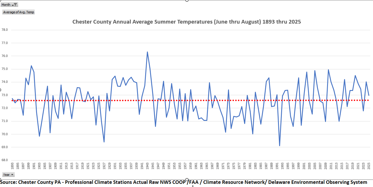
Many folks have asked for an analysis of both the Average Summer High temperature and Overall Average Temperature trends specifically for Chester County PA. Clearly steady state since 1893!

-

2026 Mid-Atlantic Severe Storm General Discussion
high risk replied to Kmlwx's topic in Mid Atlantic
Yeah, even though the timing/coverage differ, the fact that EVERY CAM has storms in the DC area later today was such a great sign this morning. An MCV with favorable timing is usually a great combination.- 459 replies
-
- 1
-

-
- severe
- thunderstorms
- (and 7 more)
-
GFS looks seasonably warm much of next week now…lower dews though.
-
Dew Points 72-75 for most of us.
-
Gorgeous day 90/70 is perfect
-

Junorch obs and discussion 2026
Damage In Tolland replied to Damage In Tolland's topic in New England
* -
0.16” this morning on east side of Columbia.
-
Quite a bit of initiation happening on the higher terrain to the west.
-
only 77 here...mostly cloudy
-
78/65 down here. Meanwhile 86/66 @ KBOS and 84/64 @ KMHT. I wonder if tomorrow and Friday will be similar with the highest temps in central and northern New England?
-
How climate catastrophism — not climate change — is harming our mental health https://www.thefreemind.co.uk/p/how-climate-catastrophism-not-climate
-
just finished staking all of my tomatoes here in chicago. ready for whatever may come. .
-
Firday
-
-
Records: Highs: EWR: 99 (2008) NYC: 96 (2008) LGA: 100 (2008) JFK: 94 (1959) Lows: EWR: 49 (1972) NYC: 49 (1972) LGA: 48 (1972) JFK: 51 (1998) Historical: 1752 - It is believed that this was the day Benjamin Franklin narrowly missed electrocution while flying a kite during a thunderstorm to determine if lightning is related to electricity. (David Ludlum) 1816: A severe frost blackened fields of beans and cucumbers from VA to New England. In some areas of the NE, trees remained leafless well into June due to the long and cold spring. (p.33 Washington Weather Book 2002 by Ambrose, Henry, Weiss) Chauncey Jerome's wife who lived in Plymouth, Conn. brought in some clothes that had been spread on the ground the night before, which were frozen stiff as in winter. (Scientific American, "The Year without a Summer" pp. 45 - 48) 1902: A tornado touched down a few miles east of Canton and moved through Kingston Mines, IL. Two people were killed near Canton, but much of the damage occurred in the Kingston Mines area, where 16 homes were destroyed. 20 men and 18 engines were buried in the roundhouse there. Eight people were killed further east, when buildings were destroyed by strong winds. (Ref. Wilson Wx. History) 1929: The first radiosonde was sent up by French Meteorologists.(Ref. Wilson Wx. History) 1957 - A dust devil at North Yarmouth, ME, lifted a 600 to 1000 pound chicken shelter into the air and carried it 25 feet. It landed upright with only slight damage. It is unknown whether any eggs were scrambled. (The Weather Channel) 1958 - A woman was sucked through the window of her home in El Dorado, KS, by a powerful tornado, and was carried sixty feet away. Beside her was found a broken phonograph record entitled Stormy Weather . (The Weather Channel) 1972: Record chill invaded parts of the upper Midwest. Locations that reported record low June temperatures for the date included: Jump River, WI: 23°, Blair, WI: 28°, Owen, WI: 28°, Alma, WI: 38°, Genoa, WI: 38°, Trempealeau, WI: 38° and Lynxville, WI: 40°. (Ref. Wilson Wx. History) 1987 - Thunderstorms produced 2 to 4 inch rains in southern Texas. Two and a half inches of rain at Juno TX caused flooding and closed a nearby highway. Flooding on the northwest side of San Antonio claimed one life as a boy was swept into a culvert. Thunderstorms in the north central U.S. produced an inch and a half of small hail at Monida Pass MT. (The National Weather Summary) (Storm Data) 1988 - Three dozen cities, mostly in the eastern U.S., reported record low temperatures for the date, including Elkins, WV, with a reading of 33 degrees. Unseasonably hot weather continued in the Northern High Plains Region. The record high of 105 degeees at Williston, ND, was their seventh in eight days. (The National Weather Summary) 1989 - Thunderstorms produced severe weather through the day and night across much of the southern half of the Great Plains Region. Thunderstorms spawned 14 tornadoes, and there were 142 reports of large hail and damaging winds. Hail three inches in diameter caused three millions dollars damage at Carlsbad, NM. Hail four inches in diameter was reported at Estelline TX and Stinnett, TX. Thunderstorm winds gusted to 80 mph at Odessa TX. (Storm Data) (The National Weather Summary) 1997: Flash Flooding occurred in many locations in Mississippi. Highway 80 and many other streets were flooded in and around Vicksburg. Water engulfed one person's car, but the person was rescued. This event caused $300,000 in property damages. Over 6 inches of rain fell in Lexington in a little over 3 hours. The torrential rains caused Bear Creek to overflow and flood much of the town of Lexington. 45 businesses were affected by the flooding and 30 of these suffered major losses. As many as 300 homes had water damage. This event caused 10 million dollars in property damages. Portions of Jones County experienced flash flooding as 3 inches of rain fell in just 1.5 hours over saturated ground. 2003: When the second tropical depression of the Atlantic hurricane season formed about 1,200 miles east of the Leeward Islands, it marked only the third time since 1967 that a hurricane had formed in the eastern Atlantic in the month of June. (Ref. Wilson Wx. History) 2008: Runoff from excessive rainfall over the previous week led to record flooding along the Embarras River at Ste Marie and Lawrenceville, IL. A number of levee breeches occurred between the 8th and 10th along the Embarras and Wabash Rivers. In Lawrence County, 75 square miles were flooded as a result. In Lawrenceville, 158 homes were flooded in the first floor living area, with 48 others having basement flooding, and 8 businesses had in excess of 5 feet of water inside. (Ref. Wilson Wx. History) 2008: June 7 - 9 , New York, New York: New York City set record high temperatures for three days running: 96 °F, 96 °F, and 99 °F.
-
87. Muggy too.
-
NAM grid suggests a hot day tomorrow. 577 dm hydrostats probably means the DPs rich so that'll likely keep the T from going too crazy but you'd be talking about 93 .. 94/76 type stuff ooph
- Today
-
With this very dry ground I'm hoping we get hit with a heavy storm at least one of the days.
-
Ah yeah I'm traveling and forgot what day it was ha Whatever happens I'll miss it
-
Obviously you meant to say 2 days starting tomorrow. The weather on Saturday will be dry with lowering humidity.
-
Have a good round today. Just keep an eye out to the west, there’s some activity out in central Pa. That could possibly swing thru later this afternoon.
-
2026 Mid-Atlantic Severe Storm General Discussion
high risk replied to Kmlwx's topic in Mid Atlantic
I agree that SVR potential today is limited by lousy shear, although MCVs can be sneaky Lousy shear will also be an issue Friday, although high instability and organization of storms along the front might counteract that. But Thursday might have the best combination of shear and instability and allow for a more widespread event, although the source of triggering is less obvious than on the other two days.- 459 replies
-
- 4
-
-
- severe
- thunderstorms
- (and 7 more)


.thumb.gif.f92b16c631a1d15d405ed77b33f0710d.gif)