All Activity
- Past hour
-
Nah…CFS is bringing the flakes in August to NY and the picnic tables.
-
 I stopped dropping around 61 degrees :/ Still I'll take it
 -
Maybe Cape Cod.
-
 July at my station finished with a mean temp of 79.9° , 3rd warmest behind 80.5 in 1999 and 80.3 in 2010.
 -
July total 6.45" Highest temp 92, lowest 63
-
Got the windows open finally! Still mostly cloudy here but I'll take it.
-
I left all the windows open and the living room was 62° this morning.
-
 1944: A hurricane formed in the Bahamas and came ashore at the North Carolina/South Carolina border. It moved north as a tropical storm, then curved to the northeast, passing across the lower Delaware Bay on its way out to sea. Philadelphia, PA received 2.39 inches of rain and 0.22 inches on the 3rd. This was the first of three tropical systems to affect the Mid Atlantic states in 1944. (Ref. Wilson Wx. History) 1944 would have been one of our most exciting summers, big heat and big east coast tropical systems!!!! 1975 - Record heat gripped New England. Highs of 104 degrees at Providence, RI, and 107 degrees at Chester and New Bedford, MA, established state records. The heat along the coast of Maine was unprecedented, with afternoon highs of 101 degrees at Bar Harbor and 104 degrees at Jonesboro. (The Weather Channel) Boston, Massachusetts had a 102 °F temperature the warmest temperature for August. (Ref. NOAA Boston Weather Events) wow 104 in Providence and we didn't hit 100? 1980: The intense heat wave continued in Texas. Dallas had their 41st consecutive day of 100° readings. The streak eventually reached 42 days. Abilene, TX was on their 41st consecutive day of 98° or higher, tying a record that dated back to 1952. El Paso, TX was on their 51st consecutive day of 100°+ temperatures. Other record highs included: Oklahoma City, OK: 110°, Tulsa, OK: 108° and Springfield, MO: 102°. (Ref. Wilson Wx. History) endless summer of 1980 continued......
 -
52.8 this morning. Haven't seen 40s here since June 4. Looks like extreme summer doldrums on the horizon. See you in October.
-
Yes that place is like an oven lol Did you get into the upper 50s last night?
-
8/9/01 really stands out, what made that day so hot-- 105 at Newark and 103 at Central Park, the day before almost reached 100 too, it was 99 at Central Park
-
and our immediate area has not seen triple digit heat after August 15th since 8/20/1983. August 2001 had a notable triple digit heat outbreak near August 10th, but that was a one off the rest of that summer wasn't even that hot.
-
The PDO has a crossover effect on this. Unless we get a 1996 type fluke (very unlikely in the current PDO) a snowy winter is off the table. It’s going to be hostile. But how hostile matters. One of the biggest factors determining between a god awful or just meh winter will be the PDO. If it’s closer to -1 for the winter like last year we have a shot. If it’s hanging out around -2 to -3 we’re in trouble. But it didn’t really start to improve until around thanksgiving last year so we won’t know for a while. But it’s not just the models. Red is crushing blue in areal coverage at our latitude overall lately. And no it doesn’t mean we can’t get a snowy winter. But it does make them less likely.
-
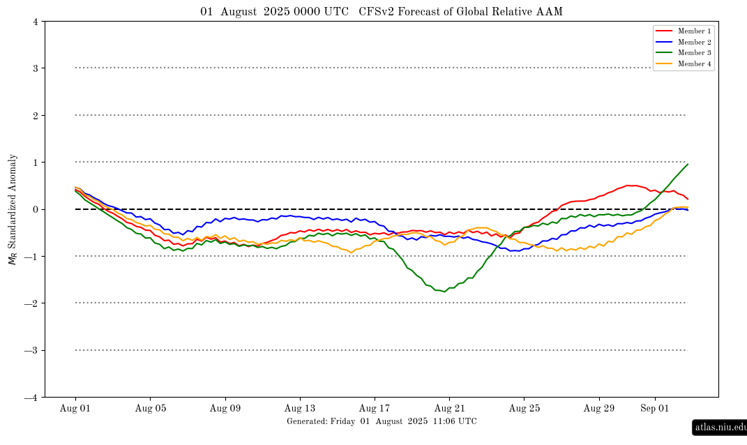
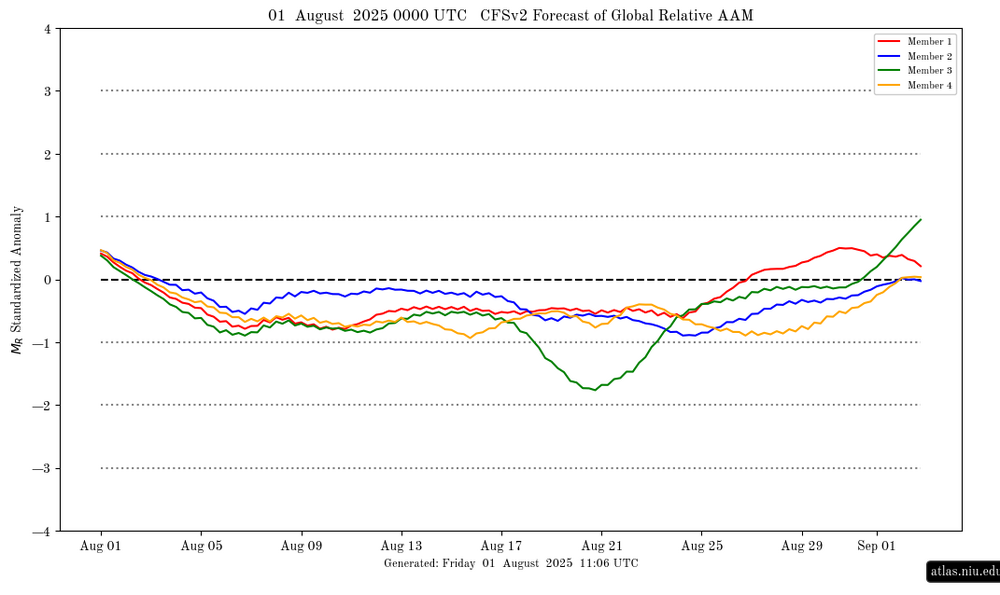
AAM finally going - (Ninaish):
-
I think Mother Nature heard your comments about the lack of rain in Marion @wncsnow
-
Overperformed to 27C/80F with low dews and fresh air on Fri. For a few days now WUN has 30C/86F continuously maybe starting Mon if we exceed by 2, all the way til the last slot on Mon the 11th! What a magnificent stretch it'd be.
-
It was steaming
-
 58.6 this am. Nice and crisp
 -
Wow what a region-wide soaker! Almost everyone participated. Some jabroni was asking if it was even going to rain lolz.
-
You wonder if today was coolest till mid/ late Octorcher
-
With a torch fall coming, gonna be speedos until Halloweenie.
-
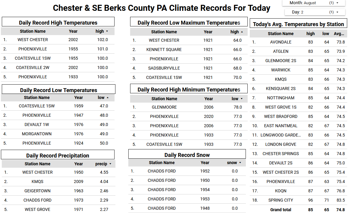
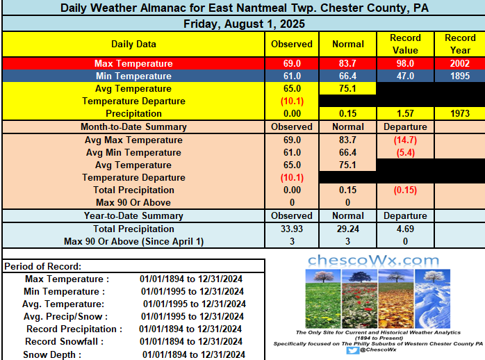
Yesterday was the 5th chilliest low maximum temperature for the date with highs remaining in the 60's at Atglen, West Grove and East Nantmeal and just past 70 degrees at most other locations. We should remain below normal today but with highs a good 8 to 10 degrees above yesterday. A great weather week ahead with temperatures at or a bit below normal for the first week of August. Low's this morning were in the 50's with the lowest at Warwick Twp. at 54.8 degrees. Lows continue in the 50's the next couple of nights with lows not too far from 60 for the rest of this week. So a great break for all of our A.C.'s.

-

E PA/NJ/DE Summer 2025 Obs/Discussion
ChescoWx replied to Hurricane Agnes's topic in Philadelphia Region
Yesterday was the 5th chilliest low maximum temperature for the date with highs remaining in the 60's at Atglen, West Grove and East Nantmeal and just past 70 degrees at most other locations. We should remain below normal today but with highs a good 8 to 10 degrees above yesterday. A great weather week ahead with temperatures at or a bit below normal for the first week of August. Low's this morning were in the 50's with the lowest at Warwick Twp. at 54.8 degrees. Lows continue in the 50's the next couple of nights with lows not too far from 60 for the rest of this week. So a great break for all of our A.C.'s.
-

Central PA Summer 2025
Mount Joy Snowman replied to Voyager's topic in Upstate New York/Pennsylvania
Low of 56. My weekend is inundated with kids birthday parties. Hoping to find time to make a fire one night.

.thumb.png.4150b06c63a21f61052e47a612bf1818.png)