All Activity
- Past hour
-

Southern MD / Lower Eastern Shore weather discussion
AlexD1990 replied to PrinceFrederickWx's topic in Mid Atlantic
Seeing a WWA one county to my north makes me feel some kind of way, lol. -
It sucks because to get any traction at all on the platform you have to be ridiculously over the top. I'm hoping to build an audience/following there with reasonable forecasts but who knows.
-

Minor snow possible sunday 12/14/25
coastalplainsnowman replied to WeatherGeek2025's topic in New York City Metro
penne for your thoughts on this -
It’s been while since we’ve seen a legit CAD setup where we get a front end thump before flip with primary lows to the NW of us. Probably because Canada was torched the last few winters iirc. Now with Canada being cold, we may have a shot at a CAD event where it’s not just a cold rain for everyone east of the Alleghenies.
-

12/14: Sunday funday? Will the south win again?
Weather Will replied to TSSN+'s topic in Mid Atlantic
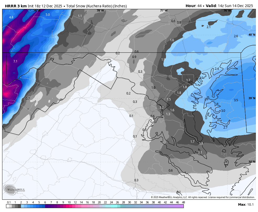
WB 18Z HRRR

-
Minor snow possible sunday 12/14/25
coastalplainsnowman replied to WeatherGeek2025's topic in New York City Metro
ok but this model [which, to a snow lover is showing no snow, or to a rain lover is showing lots of snow] is terrible at this range -
All I said is I wouldn’t want to try running too many ice storms with +10C 850s. That takes a rather extreme set of variables to pull off.
-
Nothing encouraging looking at the PNA and NAO today. NAO looks to be heading into positive territory while the PNA is heading negative after the 15th. Ops does still show lots of cold in Canada with occasional intrusions into the U.S. and even the SE over the next two weeks followed by warm ups. I see the mountains getting some NWSF with these. One just gets the impression that the models are still having a hard time reflecting the MJO. Honestly, I wouldn't be surprised to see winter stay in this relatively dry rinse and repeat typical in a Nina or turn really cold in the east in January. I am rooting for the latter!
-

Saturday night/Sunday 12/13-12/14 Jawn
LVblizzard replied to Ralph Wiggum's topic in Philadelphia Region
18z HRRR is a big nothingburger north of the Lehigh Valley and also less robust near I-95. C-1" north of Blue Mountain, 1-3" for everyone else. -
As god intended. “God bless us, everyone. “
-
Nice professional presentation with this. However, with it being on Youtube, I noticed a decided lack of hype, sensationalism and errors that usually accompany weather related videos.
-

Winter 2025-26 Medium/Long Range Discussion
mimillman replied to michsnowfreak's topic in Lakes/Ohio Valley
Glad ill be gone for this whole period. Yawn -

Minor snow possible sunday 12/14/25
jm1220 replied to WeatherGeek2025's topic in New York City Metro
To be fair, hasn’t snowed much in the last few years. -

Winter 2025-26 Medium/Long Range Discussion
Frog Town replied to michsnowfreak's topic in Lakes/Ohio Valley
Reality, but still a total buzz kill. -

December 2025 regional war/obs/disco thread
HoarfrostHubb replied to Torch Tiger's topic in New England
Not me. Been there, done that -
-
Classic CAD setup which denies the coast of the torch. So despite it being warm just about everywhere else, we’ll constantly hear about how it’s “not a torch” because the most important cities in America will be cooler.

-
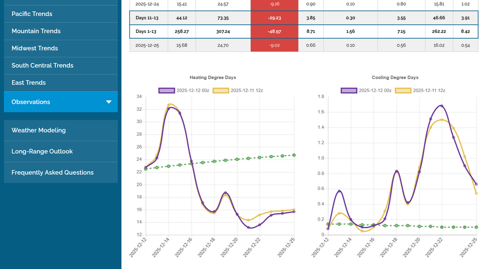
NG bulls want the opposite of this EPS HDD trajectory (see left graph): the cold part through 12/15 was dialed in to prices many days ago:
-

December 2025 regional war/obs/disco thread
WxWatcher007 replied to Torch Tiger's topic in New England
I want a roll call of everyone that would take 40° and 1” of rain over 29° and .50” of ice on Christmas Day. A trip to the in-laws can wait a day. -
https://s2s.worldclimateservice.com/climatepanel/ Then click on 2nd map on right.
-

Central PA Winter 25/26 Discussion and Obs
canderson replied to MAG5035's topic in Upstate New York/Pennsylvania
My grid now has less than 1” forecast. It was 1-2” this am. -
If I never saw 0.25 or more of ice again it'd be too soon cause I'm the guy who has to go clear our trail system after, 98 was pure devastation up here, you can keep that all south of the Pike as far as I'm concerned
-
Thanks! Where do you find that? Been interested in the PDO because of how much the negative state screwed with snow chances the last decade.
-

December 14th - Snow showers or Plowable snow?
weathafella replied to Sey-Mour Snow's topic in New England
Our man! Part of the crew kicked into the back room at JJ Foleys in 2009. -
Updated video on Sunday's storm and a look ahead in the extended. https://www.youtube.com/watch?v=5lE-tz3FZDU