All Activity
- Past hour
-

First Winter Storm to kickoff 2025-26 Winter season
moneypitmike replied to Baroclinic Zone's topic in New England
You hate to see it. -

First Winter Storm to kickoff 2025-26 Winter season
WinterWolf replied to Baroclinic Zone's topic in New England
Every post gets a terd emoji from Tiger torch…what an insufferable poster that guy is. Just plain Sad. -

First Winter Storm to kickoff 2025-26 Winter season
moneypitmike replied to Baroclinic Zone's topic in New England
Unless there's a southern component to the winds, I'll be fine here. Further down the coast is a different story as due east is off the water there. -
First Winter Storm to kickoff 2025-26 Winter season
dryslot replied to Baroclinic Zone's topic in New England
-
It's a little unusual to see snow accumulation on trees, grass, and car tops in the middle of the day and snow fog/ low visibilities with surface temperatures between 35F and 37F. And outside of a few bursts, the intensity hasn't been all that great either. This is an overperforming airmass.
-

December 2025 regional war/obs/disco thread
WinterWolf replied to Torch Tiger's topic in New England
Really? Sometimes I wonder what you are really thinking? Why would you ever base any ideas on what may happen in the longer range on OP runs. That post deserves a 100 bun salute if there ever was one worthy of it. As Anthony says…are you new here? -
I agree with leaning towards the 3K. Even in the short range, the 12K over performs more so. We’ll see how this plays out. A bunch of runs to go.
-
Mid to long range discussion- 2025
SEwakenosnowforu replied to wncsnow's topic in Southeastern States
Hey CAD...it's beffrey2.. it's cuz he is tired of getting screwed year after year. I totally feel his pain! Hope all is well. -
The 3” would be up near Yorktown Heights with less than an inch for Yonkers. Westchester is a tale of two worlds. The dividing line is often near Hastings on 87.
-
Given the snow type, amount, and post cold easily the greatest November event and Thanksgiving event in my lifetime. Not close. Even the 1975 event fell mainly at night and was slop by morning. Tracked it even back than as a 7th grader. Played my NOAA weather radio non stop.
-
First Winter Storm to kickoff 2025-26 Winter season
Snowcrazed71 replied to Baroclinic Zone's topic in New England
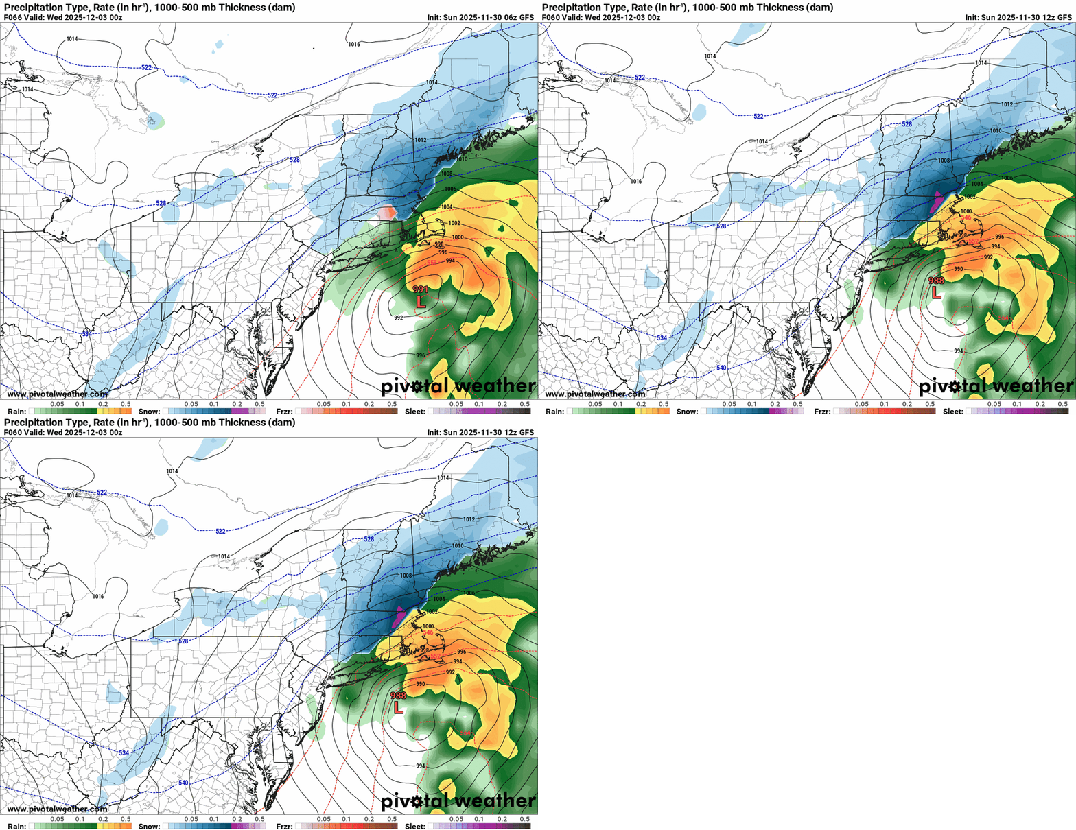
I agree... Look at the GFS.. it's been trending SE now over the last few runs. Let's just hope the Euro 12z holds and stays right on us. -
First Winter Storm to kickoff 2025-26 Winter season
dryslot replied to Baroclinic Zone's topic in New England
Yes, Its pretty tough this time of year with SST's still cooling from summer at the water unless you have a very cold airmass in place. -

Central PA Fall Discussions and Obs
WmsptWx replied to ChescoWx's topic in Upstate New York/Pennsylvania
I do like that the first "widespread" threat isn't from something flukey like Huron streamers or a clipper. -
Accuweather saying 1-3 for Westchester. Thats trending positive and I wouldnt write this off yet
-

First Winter Storm to kickoff 2025-26 Winter season
tunafish replied to Baroclinic Zone's topic in New England
I think GYX has rhe right idea trimming the totals on the coast. East winds to start while the water is still 49°. -
Currently 31.3 here.
-
I could see a last minute cold tick that would bring accumulating snows to the coastal interior (West of the PIP and North of Rt 80) but as of now I think it’s mostly confined to the higher elevations of NW NJ and areas North and West of the 287/17/87 junction near Sloatsburg.
-
Probably every year for a few days till reality kicked in
-
Yes, a trough over Japan is always preferred!
-
When is the last time we tracked at the end of November.... kinda cool just doing that...
-
Snowy morning at 500ft in Morris County. Nice surprise coating! The bigger surprise is that the temperature has dropped almost 2.5 degrees since 10am allowing the trees to become increasingly frosted. Feels very festive.
-
The RRFS looks reasonable with 2-4 or 3-5 up that way which is good news because it'll be the NAM replacement within a year.
-

First Winter Storm to kickoff 2025-26 Winter season
CoastalWx replied to Baroclinic Zone's topic in New England
Close to MLK meltdown -

Nov 28-30th Post Turkey Day Winter Storm
RCNYILWX replied to Chicago Storm's topic in Lakes/Ohio Valley
Call it 8.1" for me. Nearest CoCoRaHS (Naperville 2.5 ESE) had 8.5". Looks like about 8-9" was the range in this part of the southwest burbs. My largest (and favorite) November event since I've lived out here and largest overall for my area since Feb 1-3, 2022. The most recent big late November event in 2018 was slop in the southwest burbs until the very end. Sent from my SM-S936U using Tapatalk -
always a low in the great lakes. Its like a permeants feature now


