All Activity
- Past hour
-
 I'm gonna do some painting upstate.
 -
Recon is in there now so we should know soon how close it is, or not.
-
Too early for me. 50s at night is great, but not even reaching 70 in the middle of the afternoon is a bit much. Plus lake effect clouds.
-
Still holding together as best it can in a very hostile environment
-

Occasional Thoughts on Climate Change
gallopinggertie replied to donsutherland1's topic in Climate Change
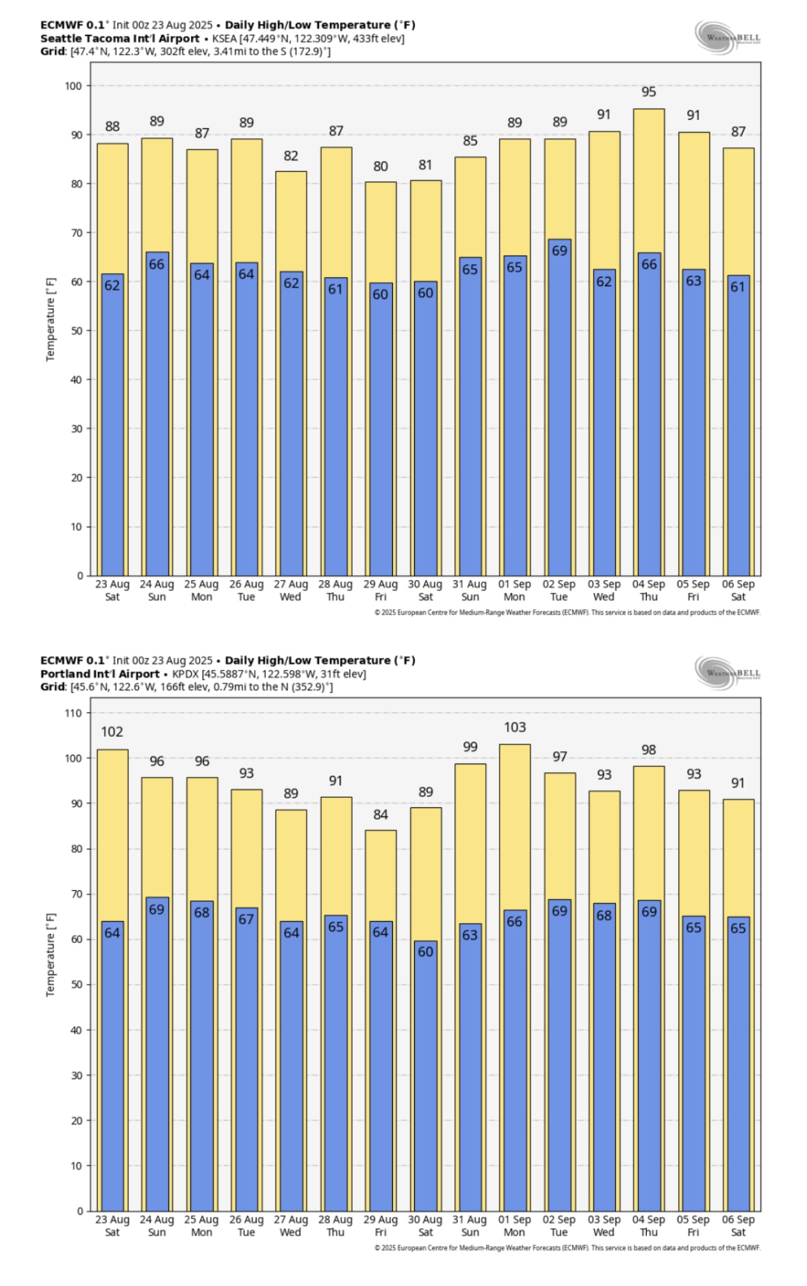
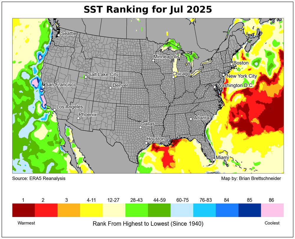
It’s looking like this might only be the beginning of this particular hot period - here’s the new ECMWF forecast for Seattle and Portland, showing a two-week stretch that would average 10-15 degrees above normal for the region. Pretty wild. I’ve lived in western Washington and Oregon my whole life, and the summer climate has really changed over just the past couple decades. Like you posted about, heat waves used to last maybe two or three days - now they stretch on for a week, or longer. Here in Portland our climate averages have historically fallen in the Csb (warm-summer Mediterranean) range, but are on track to push into Csa territory (hot-summer Mediterranean) before too long, perhaps when the new 2000-2030-year averages become the new baseline. Seattle probably will follow a few decades later.
-
Currently 80/55 here in Tamaqua with a nice breeze blowing. This is about as perfect a summer day as you can get.
-
And I thought 0.28" was bad. Driest month since moving here is 0.31" in April of 1999. I think Monday will allow that mark to stand. 2nd is January 2004 at 0.57" and that may be in play. 3rd is 0.84" in both November 2012 and September 2014. I think they'll be tied for 4th on 9/1.
-
We had a record Southeast Ridge in July. So record Atlantic warm pool is in the mid-latitude band off the East Coast The record ridge back in the summer of 2023 was east of Canada leading to the record SSTs at higher latitudes.

-
What really gets me is all this hype information about La Nina winter coming. Like it's big headlines and it's going to be this strong La Nina. It seems to me that this La Nina pattern will be a very weak pattern and it won't even last all winter, but there's just so much out there on what they're saying. Honestly, the information is so misinformed on exactly what's going to happen that people just take what they read and go with it. Well in a week we'll be starting September and starting to get a better picture on where we're going. Starting to feel a bit of excitement.
- Today
-
 Yeah the big deal next week will be the very low humidity rather than the temps. Starting on Tuesday, a very long stretch with dewpoints in the 40s to near 50. That with high temps near 80 will be absolutely perfect summer weather.
 -
The North Atlantic is night and day this year compared to 2023. That big cold pool south of Greenland and up Davis Straight has been incredibly persistent since spring. Basically the opposite of the heatwave off of Japan in the Northwest PAC
-
the north end is cool
-
There isn't any 'new way' to fail. The way we win is the same as it has been lately with predominately -ENSO and the tendency for ridging in the EPO space. Time a wave moving along the thermal boundary when it's just to our south, and be content with light to moderate events. If we get really lucky maybe a couple pieces of energy phase early enough to get something bigger.
-
After a dry Aug in my neck of the woods, hoping for more precip starting in Sept. To me, it looks like a roller coaster pattern early, and later in Sept, with mid month sporting some very cool wx. Need the rain tho so as not to fall to far behind. Did well in July with it being the 8th wettest here in TH bringing YTD to near avg at the end of that month.
-
^Much nicer without any smoke. I swear, this year was one of the worst for that. More AQ alerts as the smoke was near surface many more days than the past few years. Probably because the fires were mainly concentrated in SC CAN than being more in the W CAN areas. With more distance, the smoke was more aloft then.
-
Currently cloudy and 71.1/65.8 at 11:20 am. Didn't get as cool as northern folks, think the clouds and fog held us up, low was 62.6 degrees this am.
-
This is the 1st time I can recall them going near 100% and them not designating it a TC at the next 6 hourly normal issuance time! If they’re waiting for recon, why not go 90%? Or why not issue a PTC advisory?
-
0.35" from a stm that moved through last night bringing the monthly total to 0.91" which is well below normal. Today feels like late Sept wx moved in on a NW wind. Highs in the 60's(maybe low 70's) with 30's/40's for lows the next few days. Great football wx tho.
-
Stein not helping matters
-
We just drove to Sugar Hill and the corn fields along the way are so dry that it looks like they’ve already had a frost.
-
 This week's cooldown looks to be just slightly below average now. Maybe a -5 on Wednesday with cool lows
 -
 Departures through 8/22 - two thirds of Aug Likely 2-3 above normal today/sunday and maybe monday, before below normal stretch Tue - Soundly putting all between 1.5-3 below normal for the month. EWR: -1.4 NYC: -1.8 JFK: -1.9 LGA: -2.6
 -
They're going crazy today. Not the day to eat outside.
-
AK : Hot fun in the summertime
-
this past week's cool - wonder if we'll see departures equal to these or if this period will be cooler overall than this coming week. EWR: 8/18: 78/ 66 (-4) 8/19: 76 / 68 (-4) 8/20: 71 / 60 (-10) 0.53 8/21: 75 / 60 (-8) 0.14 8/22: 85 / 60 (-3)