All Activity
- Past hour
-
don't get me wrong, the overseeding is coming up fantastic, looks great right now. I've had to water daily as well, and I haven't mowed since 8/30. it's getting tall
-
See my post above. He is very good at moving in the pocket, buying time, extending the play, then hitting a receiver downfield, but there are limits. Got to feel the pressure and run or throw the ball away. On at least 3 of those sacks he could have run and gained yards.
-

September 2025 OBS-Discussion centered NYC subforum
MJO812 replied to wdrag's topic in New York City Metro
Thats if we dont get any tropical activity up here -
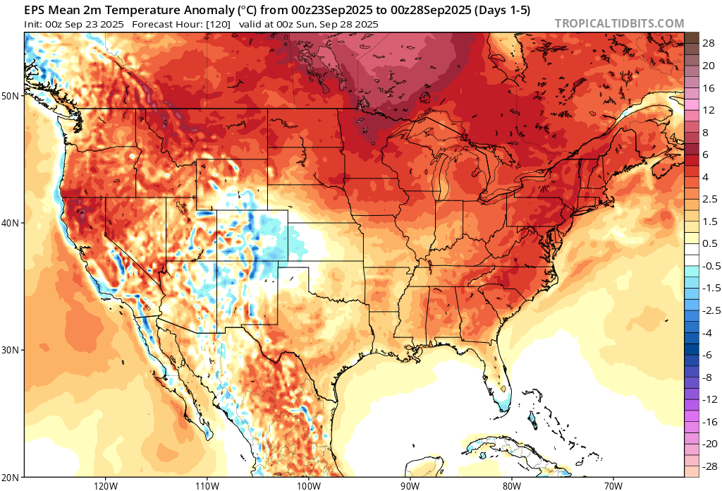
Wet pattern looks to develop end of the week and depending on any possible tropical system we could see some hefty rainfall totals into next week. Check the Euro, over 1 foot for much of NC. That being said, amounts could be drastically lower if the lead wave fails to develop or stays offshore
-
Ravens have a fumble problem. And since when does Lamar get sacked 6 times?
-

2025 Atlantic Hurricane Season
NorthHillsWx replied to BarryStantonGBP's topic in Tropical Headquarters
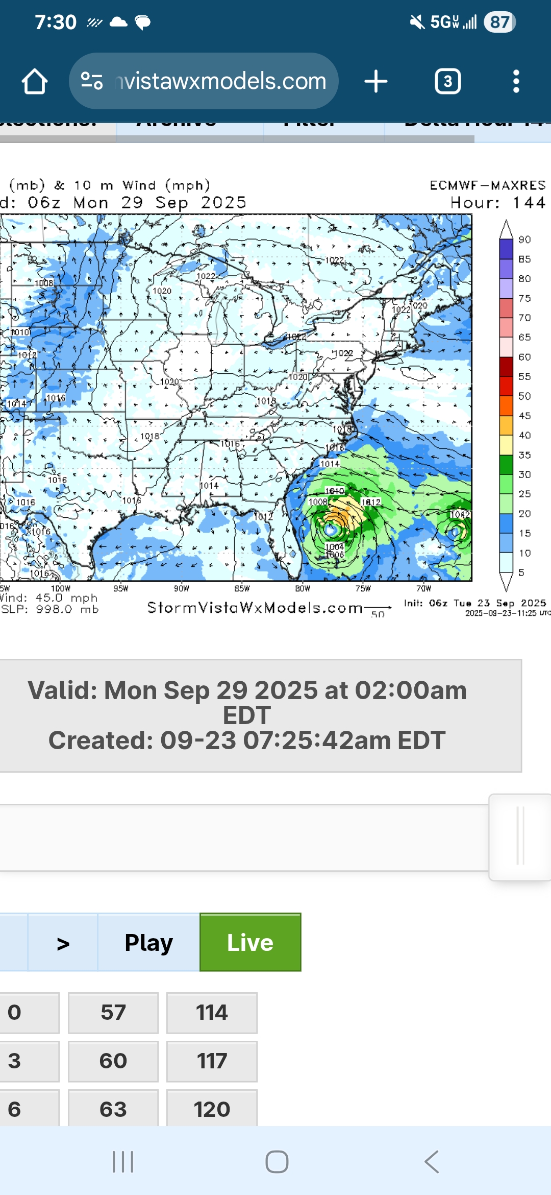
Really interesting forecast with our cherry and our orange. Several possibilities with regards to storm formation, intensity, which waves becomes dominant, and potential land impacts. The only real positive is if anything develops from the Orange and moved to the coast the environment looks prohibitive for significant strengthening with a lot of continental dry air and an ULL over the SE but I could definitely see a tropical storm impact if that waves gets going as that ULL could try to pull it westward. The cherry would likely remain ots if it develops. I think the evolution of each individual wave will impact the outcome of the other as they are not far apart and we may actually see a merger. Very volatile atmosphere right now with very low model consensus but I am becoming confident we get a storm between the two -
6z Euro
-
Also Lamar needs to have a better feel for when to stop trying to buy time to find an open receiver downfield and just throw the ball away or run- several times last night he had a wide open lane to take off and gain significant yardage and ended up taking a sack. His mom will be yelling at him this morning about that.
-
I will give it a go. Hopefully, some of the Nooga folks will chime in. Tough time of day to get a good grasp on. Afternoon storms are a risk in this pattern. Signal Mountain is also an entirely different ball game due to its elevation. If it is anything like my area here in TRI, modeling will often miss things above 1500'. Firstly, I am not a good short range summer weather source. I did check the RGEM, HRRR, and NAM 3k this morning for your local. I think what you shared is probably accurate. The RGEM is a hair earlier than 7PM. It is worth noting that modeling has been hit or miss with afternoon storms of late over E TN - i.e. not overly accurate. A lot of these lines and cells have been slow movers. By late morning or lunch today, if it were me...I would really keep an eye on short range, hi-res modeling which is derived from radar. The Signal Mountain NWS point and click is this for the entire day (25% from 4-7PM).... A 40 percent chance of showers and thunderstorms, mainly after 4pm. Partly sunny, with a high near 83. South wind around 5 mph becoming southwest in the afternoon.
-
Summer vibes today. Looks like 82/65 dewable imby.
-
They can still be a top team but there are things that need to change, and one of them is the rigid nature of the coach. The offense is fine and will get better if/when Ricard is back and Likely should be back against the Chiefs. Ofc Mitchell needs to play, but that goes back to my first point. The defense is just awful right now- partly injuries but they were bad before KVN and Madubuike got hurt. Probably wont happen, but I think Pagano should be promoted or have a bigger role in game planning. Looks like Henry might be on the edge of the aging RB cliff.
-

September 2025 OBS-Discussion centered NYC subforum
qg_omega replied to wdrag's topic in New York City Metro
Pattern still looks very dry next few weeks -
I think they very well could still win the division. But they clearly aren’t able to compete against other playoff caliber teams.
-

September 2025 OBS-Discussion centered NYC subforum
SnoSki14 replied to wdrag's topic in New York City Metro
Endless summer with 80s deep into October -
59/59....gosh i don't think I have washed my car in awhile, boy we need rain, hope we all cash in.
-

September 2025 OBS-Discussion centered NYC subforum
bluewave replied to wdrag's topic in New York City Metro
Very rare occurrence this August and September. Several stations are on track for a colder August monthly minimum temperature than in September. First time at Allentown since 1982. Looks like a warmer pattern to close out the month. Monthly Lowest Min Temperature for Trenton Area, NJ (ThreadEx) Click column heading to sort ascending, click again to sort descending. 2025 49 50 49 2024 52 45 45 2023 57 50 50 2022 58 41 41 2021 58 49 49 2020 58 40 40 Monthly Lowest Min Temperature for PHILADELPHIA/MT. HOLLY WFO, NJ Click column heading to sort ascending, click again to sort descending. 2025 48 49 48 2024 51 44 44 2023 54 49 49 2022 57 44 44 2021 59 49 49 2020 58 40 40 Monthly Lowest Min Temperature for SOMERSET AIRPORT, NJ Click column heading to sort ascending, click again to sort descending. 2025 44 46 44 2024 48 40 40 2023 52 45 45 2022 53 37 37 2021 53 45 45 2020 54 34 34 Monthly Lowest Min Temperature for Allentown Area, PA (ThreadEx) Click column heading to sort ascending, click again to sort descending. 1986 41 38 38 1934 41 43 41 1927 42 40 40 1982 43 47 43 1976 43 38 38 1944 43 38 38 1940 43 34 34 2025 45 47 45
-
3 straight days of MRGL per SPC... today through Thursday
- Today
-
What a torch overnight.
-

Central PA Summer 2025
Mount Joy Snowman replied to Voyager's topic in Upstate New York/Pennsylvania
Low of 64. Let the rain cometh. -
This is what they do . Glad you all made it out ok
-
lol
-

September 2025 OBS-Discussion centered NYC subforum
wdrag replied to wdrag's topic in New York City Metro
Glad it worked out despite off by 4 miles on storms... and much thanks for the followup review (including dance)! -
Dews up hoes down right thru the weekend
-
Dews out there.
-
wtf glad you’re safe. Wow.