All Activity
- Past hour
-

Hurricane Erin - 155 mph - 923mb - W @ 17
yoda replied to BarryStantonGBP's topic in Tropical Headquarters
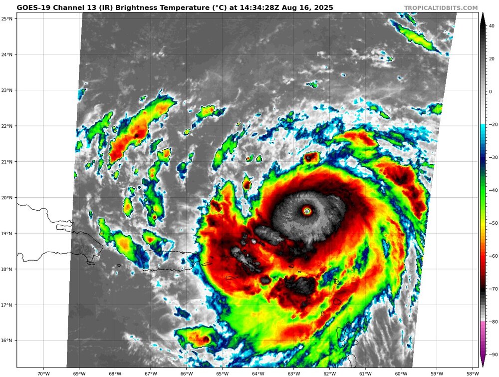
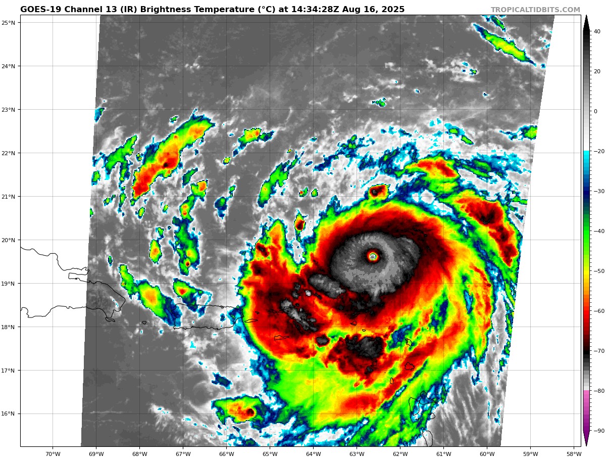
138 WTNT45 KNHC 161433 TCDAT5 Hurricane Erin Discussion Number 21 NWS National Hurricane Center Miami FL AL052025 1100 AM AST Sat Aug 16 2025 Erin has continued to rapidly strengthen during the past 6 h and is now a category 4 hurricane. Reports from Air Force Reserve Hurricane Hunter aircraft indicate that the central pressure has fallen to 925 mb inside a 6 nm wide eye, and flight-level winds in the northern eyewall support surface winds in the 130-135 kt range. The initial intensity is increased to 135 kt, a 70-kt increase since 24 h ago. The aircraft, along with land-based radar data from Sint Maarten, report that an outer eyewall is starting to form. However, this has yet become apparent in the aircraft wind data. The hurricane has been moving a bit to the left of the previous forecast track with the initial motion of 280/15. The track guidance suggests that Erin will turn back to the west-northwest with a decrease in forward speed during the next 6-12 h on the south side of a subtropical ridge. This motion should then continue through the weekend, taking the core of Erin to the north of the eastern Caribbean Islands through Sunday. After 36 h, the western side of the ridge is expected to weaken, due to a series of shortwave troughs moving through the mid-latitude westerlies, and that should cause Erin to slow further and make a gradual turn to the north. The track guidance models are in general agreement with this scenario, but there remain some differences on where, when, and how sharply Erin makes the northward turn. The new track forecast is shifted to the south during the first 12-24 h based on the initial position and motion, and it lies near the southern edge of the guidance envelope. From 24-72 h there track has been shifted westward due to an overall shift in the guidance, and the track is similar to the previous track at 96 and 120 h. The development of the outer eyewall suggests that rapid intensification should end during the next several hours. However, Erin is expected to reach category 5 status before this occurs, and the new intensity forecast now calls for a peak intensity of 145 kt. After 12 h, the environment becomes a little less favorable, with increasing northwesterly shear and possible dry air entrainment. This should lead to gradual weakening of the cyclone through 72 h, although superimposed on this trend will be fluctuations due to eyewall replacement cycles. After 72-96 h, the cyclone is expected to move into the westerlies where the shear is stronger, and a faster weakening trend is expected at that time. The new intensity forecast is at the upper edge of the intensity guidance at 12 h and near the intensity consensus after that. Although Erin is a somewhat compact hurricane now, the models are in strong agreement that the system will grow in size over the next several days. In fact, by the middle of next week, Erin is forecast to at least double or triple in size, which will result in rough ocean conditions over the western Atlantic. KEY MESSAGES: 1. Heavy rainfall at times through Sunday across the northern Leeward Islands, the Virgin Islands, and Puerto Rico may lead to locally considerable flash and urban flooding, along with landslides or mudslides. 2. Gusts to tropical storm force in Erin's outer rainbands are likely in portions of the northern Leeward Islands through tonight and over portions of the Virgin Islands and Puerto Rico later today through Sunday. Tropical-storm force wind gusts are possible in the Turks and Caicos Islands and Southeast Bahamas 3. Erin is expected to produce life-threatening surf and rip currents along the beaches of the Bahamas, much of the east coast of the U.S., and Atlantic Canada next week. 4. Interests in Bermuda should continue to monitor the progress of Erin since there is a risk of strong winds, heavy rainfall, and high surf by the middle part of next week. FORECAST POSITIONS AND MAX WINDS INIT 16/1500Z 19.7N 62.8W 135 KT 155 MPH 12H 17/0000Z 20.1N 64.7W 145 KT 165 MPH 24H 17/1200Z 21.0N 66.8W 140 KT 160 MPH 36H 18/0000Z 22.3N 68.5W 135 KT 155 MPH 48H 18/1200Z 23.5N 69.7W 130 KT 150 MPH 60H 19/0000Z 24.9N 70.4W 125 KT 145 MPH 72H 19/1200Z 26.4N 70.9W 120 KT 140 MPH 96H 20/1200Z 30.6N 70.9W 115 KT 130 MPH 120H 21/1200Z 35.7N 66.4W 95 KT 110 MPH $$ Forecaster Beven -
Yeah. It's interesting how bad the 1880-1900 period was for GA/SC, 1893 and 1898 particularly. Otherwise very rare new gfs rips the potential next system into the gulf, euro recurves similar to Erin.
-
What a beast, cloud tops in the eyewall are still cooling and becoming more symmetrical
-
This neighborhood has had 2-3 strikes just this summer. We sit on ledge which I think attracts lightning . The one in MBY was right before July 4 and another was 5-6 houses down in that wild strobe light overnight MCS
-

Hurricane Erin - 155 mph - 923mb - W @ 17
Windspeed replied to BarryStantonGBP's topic in Tropical Headquarters
Based on the last pass, I would be surprised if the NHC doesn't upgrade to at least 160 sustained and 922 mb at 11 AST. Keep in mind that Erin is embedded in a higher background pressure regime at its location, so anything around 925 mb or lower is definitely supportive of Category 5 intensity. -

2025-2026 ENSO
PhiEaglesfan712 replied to 40/70 Benchmark's topic in Weather Forecasting and Discussion
Yeah, don't forget after Andrew in 1992, we didn't get another major hurricane the rest of the way. We may get some more storms, some may even be a C1 or C2, but the odds are that we aren't going to get a storm of Erin's strength the rest of the way. -

Hurricane Erin - 155 mph - 923mb - W @ 17
hawkeye_wx replied to BarryStantonGBP's topic in Tropical Headquarters
919 mb extrap, 156 kts FL wind -

Hurricane Erin - 155 mph - 923mb - W @ 17
Eskimo Joe replied to BarryStantonGBP's topic in Tropical Headquarters
Cat 5 at 11am? -
Beavers called up for today’s game.
-
Let’s pull 85-90
-
Seems reasonable
-

Hurricane Erin - 155 mph - 923mb - W @ 17
SnowenOutThere replied to BarryStantonGBP's topic in Tropical Headquarters
926 drop according to tropical tidbits -
I don’t think there will be any debate on that indisputable fact. The question remains, how will this tropical season finish in terms of ACE and named storms, all added up, said and done, on November 30th, which is what really counts. There are signs that at least early-mid September will become quiet again. Despite the current uptick in ACE to this point with Erin, I still have very serious doubts that this 2025 Atlantic hurricane season will end up above normal in ACE or in named storms
-
We are headed to Narragansett tomorrow, spending the week. How much will this impact the beaches later this week in terms of tides and rip current?
-
 I love climate change talk because I love winter. And my favorite season is Autumn, the biggest casualty of climate change.
 -
Okay it's one op run at the very end of its range, with no real agreement with its ensembles... but since it shows this, it'll probably come true.
-
Savannah and Hilton Head rarely get hit by hurricanes. David in 1979 but only Cat 1.
-

Hurricane Erin - 155 mph - 923mb - W @ 17
NorthHillsWx replied to BarryStantonGBP's topic in Tropical Headquarters
What a freaking specimen -
 winter related username doesn't like climate change talk, many such cases
 -
 Not only that but no one is required to actually read each post. I can't be the only one who scrolls through the thread and read only the stuff that interests me at the time. Suns out, guns out here, 76/71.
 -
Have him commandeer the vessel and punch the core.

-
It would be pretty weird to discuss hyper local temperature and precipitation trends in a general climate change thread. And departures don't mean shit anymore unfortunately when they're shifting so quick. Your -1 was considered slightly above normal just 5 years ago. I'd rather discuss overall monthly averages and rank them coldest to warmest according to the available record than use departure.
-
Due to Erin ACE is now rapidly rising with 2025 about to cross median for the date (of last 75) and should cross mean tomorrow. 2025 should reach top 20 for the date by Mon and top 15 or higher by Tue or Wed. @snowman19@mitchnick
-
Nasty stuff. Pic below is from 3/27/21, a day after that 70-foot fir tree was blown apart, 55 yards from the house. In addition to traumatizing our yellow Lab mix (she was still shaking 45 minutes later), the strike ruined the connection between our generator and its dedicated panel. We only learned that in April when power went off. Genny started as usual but no transfer to the house. Technicians came and created a manual work-around (in rain turning to snow plus wind) so I could go down-cella, open the panel and flip the switch, until they could do a complete fix when the ground had thawed. Last winter the transfer again quit but I could do the manual switch; the tech came in the spring and had to replace the toasted auto-switch within the panel - probably had been compromised back in 2021 then finally died.

-
A friend is scheduled to go on a cruise to Bermuda later this week. Going to be close


.thumb.png.4150b06c63a21f61052e47a612bf1818.png)