All Activity
- Past hour
-
Watch up
-
Knew it didn’t read well, but figured I could avoid a sick joke involving my 72 y/o MIL. Apparently not.
-
Finally MCD'd.
-
It looks like a hefty line is forming in western VA. I'm surprised there's not a watch box yet.
-
Meso discussion out Mesoscale Discussion 1363 NWS Storm Prediction Center Norman OK 1144 AM CDT Thu Jun 19 2025 Areas affected...portions of the Northeast Concerning...Severe potential...Watch likely Valid 191644Z - 191815Z Probability of Watch Issuance...80 percent SUMMARY...Scattered strong to severe storms are expected this afternoon with a primary threat of damaging wind gusts. DISCUSSION...Visible satellite imagery shows deepening towering cumulus across central and eastern New York amid moderate instability in an uncapped environment. As storms deepen, some organization/updraft rotation is expected given moderate shear (50 knots at 3km per ENX VWP). Damaging wind gusts and isolated large hail will be the primary threat from this activity. Storm coverage may be somewhat isolated early this afternoon as the upper-level trough and surface front remain across the eastern Great Lakes/southern Ontario. Additional storms may arrive this evening as those features move east, but instability will likely be weaker by this time, and the severe threat remains questionable by later this evening. ..Bentley/Hart.. 06/19/2025 ...Please see www.spc.noaa.gov for graphic product... ATTN...WFO...GYX...BOX...BTV...OKX...ALY..
-

E PA/NJ/DE Summer 2025 Obs/Discussion
BBasile replied to Hurricane Agnes's topic in Philadelphia Region
First 90F day of the year and it's torturous. After a week of 60F days. Thunderstorms are required after this.
-
read this one quick and, yikes. you did what?
-
I brought my daughter down a couple years ago and we stopped in at Skaket Beach near low tide. I forgot how crazy it gets with the tide...just sand for like a mile into the bay. Should be back in August staying at a place on Pamet Harbor in Truro.
-
RIP to those who didn't listen to Kevin.
-
Yeah, i'm good with that mess. Usually when the beaches are jammed, I'll park at one of the road shoulders at Rye and set up shop on one of the rocks. lol
-
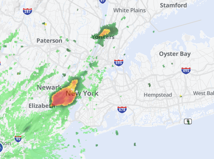
Storm cells popping up in NJ and moving in the area earlier than modelled. We might be in for a stormy afternoon.
-
 You may still enter the contest until 0200h EDT (06z June 20) ... I am posting this now to give last-minute entrants and current forecasters a quick overview of forecasts already made ... so far twenty have entered and all have managed to find a unique set of values.The consensus as median involves rounding two of four values up, I will probably change the contest consensus to a mean value if it gives a better set of numbers. At 0200h or a few minutes later, I will edit out this table and post it after all on-time forecasts that may be placed below in the thread. __ Table of entries __ 2025 seasonal max __ FORECASTER _________________ DCA _IAD _BWI _RIC gopper (16) ____________________ 103 _ 102 _ 102 _ 102 batmanbrad (19) _______________ 103 _ 101 _ 102 _ 100 Roger Ramjet (20) _____________ 102 _ 101 _ 103 _ 103 tplbge (14) _____________________ 102 _ 100 _ 101 _ 101 DanTheMan (8) ________________ 101 _ 103 _ 104 _ 103 Roger Smith (1) _________________ 101 _ 101 _ 102 _ 100 GramaxRefugee (18) ____________100 _ 101 _ 102 _ 101 biodhokie (17) __________________ 100 _ 101 _ 101 _ 100 wxdude64 (13) _________________ 100 _ 100 _ 102 _ 100 George BM (2) _________________ 100 __ 99 _ 101 _ 101 ___ consensus _________________ 99 __ 99 _ 100 _ 100 MillvilleWx (7) ___________________ 99 __ 99 _ 100 _ 102 Rhino16 (5) ______________________ 99 __ 99 __ 99 _ 101 Jenkins Jinkies (9) ______________ 99 __ 99 __ 99 _ 100 NorthArlington101 (6) ____________99 __ 99 __ 99 __ 99 RickinBaltimore (10) _____________ 99 __ 98 __ 98 __ 99 WxUSAF (4) _____________________ 99 __ 97 _ 100 __ 99 toolsheds (12) ___________________ 99 __ 97 __ 99 _ 101 Weather53 (21) __________________ 98 __ 99 _ 100 __ 99 nw baltimore wx (3) _____________ 98 __ 98 __ 99 __ 99 Its A Breeze (11) _________________ 98 __ 98 __ 98 __ 99 Prince Frederick Wx (15) ________ 98 __ 97 __ 98 __ 98 ____________________________ Consensus is median of forecasts. The mean of forecasts is 99.9, 99.5, 100.4, 100.3 or 100 _ 100 _ 100 _ 100, Of 21 forecasts, nine have all locations at 100 or higher, five have no locations reaching 100F, seven have a blend. Ranges are 98-103, 97-103, 98-104, 98-103
 -
She’s okay. I pulled out the slip n slide for her.
-
 DCA:98 IAD:99 BWI:100 RIC:99 Ladt summers champ with an incredible departure total of ONE is in da house!!!! or was it the year before?
 -

2025-2026 ENSO
michsnowfreak replied to 40/70 Benchmark's topic in Weather Forecasting and Discussion
1983-84 was a good winter! Cold and snowy. No memorable storms but 51.8" of snow overall and temps well below avg (28th coldest on record). We saw the coldest temp on the 21st century with -21F on Jan 21 (not to be confused w/ the coldest day, Jan 19, 1994, high -4, low -20). -
This means that the NOAA daily PDO is likely back down to the -2.5 to -3 range.
-
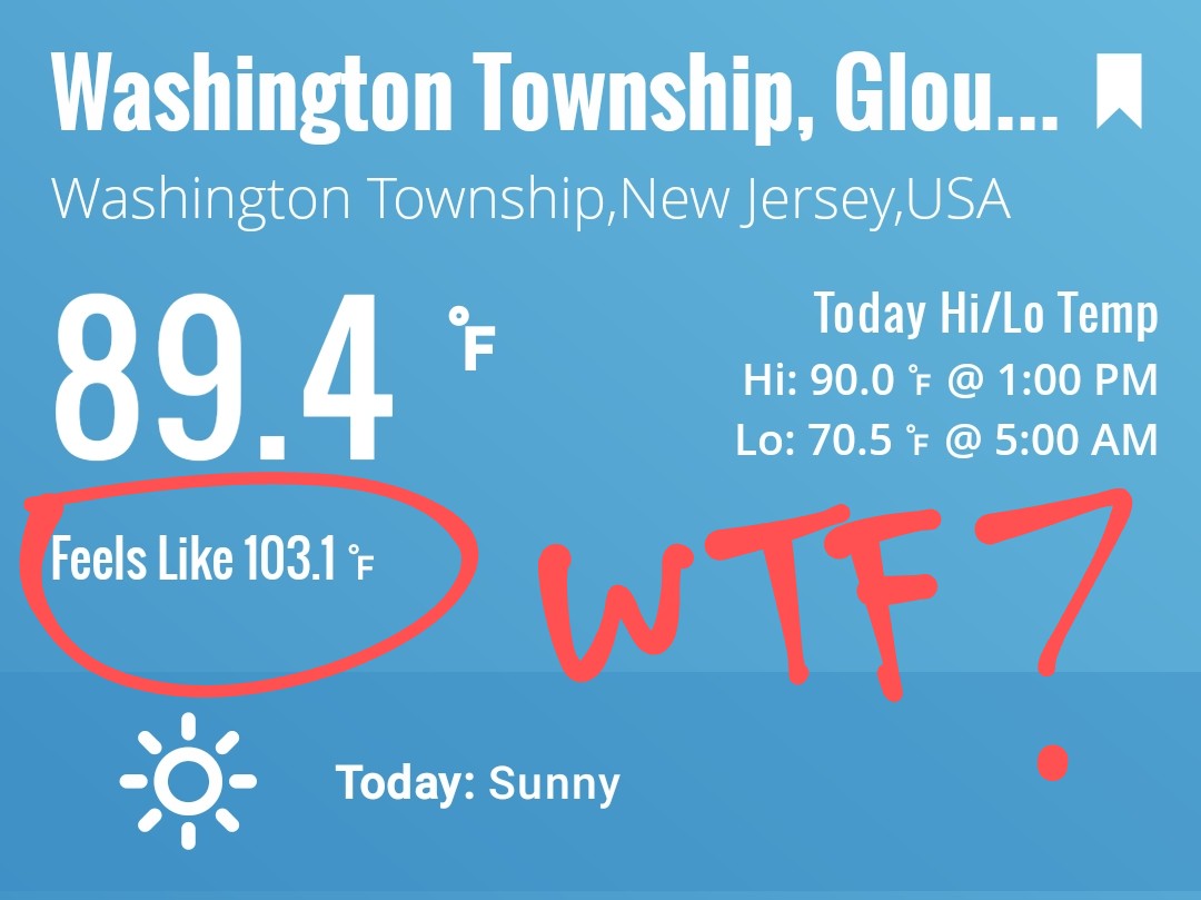
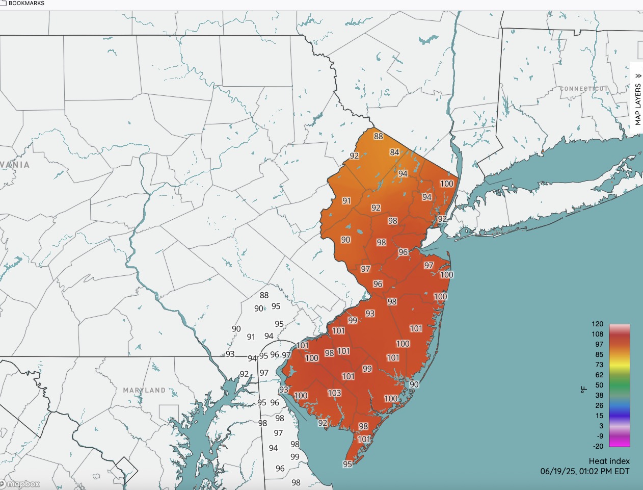
Latest HI numbers. We have cracked 100 in spots.

-
63, cloudy and a NW breeze at 1pm. Hard to believe whats lurking.
-
84/72 Feels great!
-
Nothing close to severe yet
-
"The solar winds, keep comin' in"...
-
Nice storm starting to build over my house. Could feel the cold the breeze from it
-
MU says this is the line to watch: https://weather.cod.edu/satrad/nexrad/?parms=LWX-N0B-1-24-100-usa-rad This will be through here by 4pm. CTP doesn't ramp up precip chances until after 5pm.
-
Air is juicy
-
If you ever get the chance, go to the Bay side of the Cape in August. Especially Brewster to Welfleet. The water is so shallow that when the tide comes back in over those flats...it may as well be FL. It's pretty awesome. First Encounter beach in Eastham is one of my favorites. Nice lazy river there to go floating on as the tide comes in or out.