All Activity
- Past hour
-
Also charlotte spent all that time and effort brining the roads just for it to all wash away overnight.
-

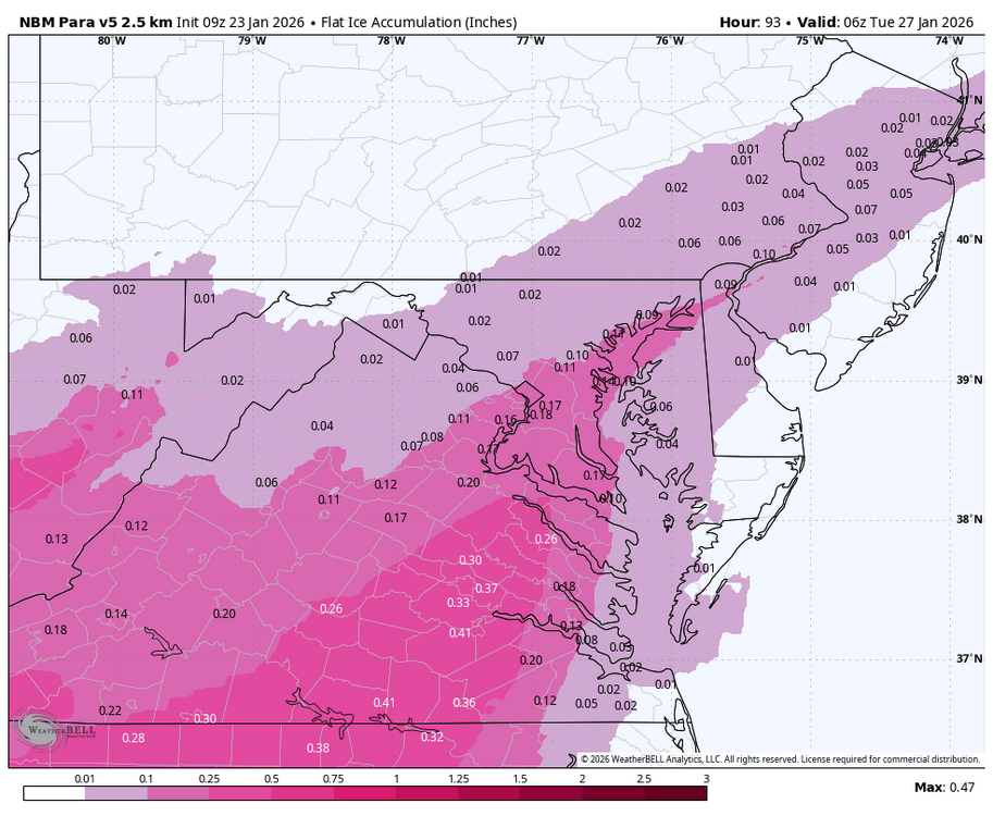
Central PA Winter 25/26 Discussion and Obs
Blizzard of 93 replied to MAG5035's topic in Upstate New York/Pennsylvania
Great write up by CTP. -
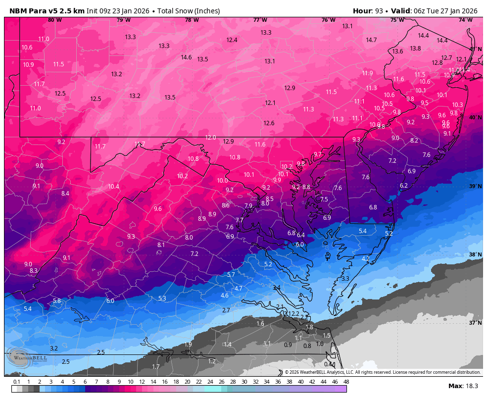
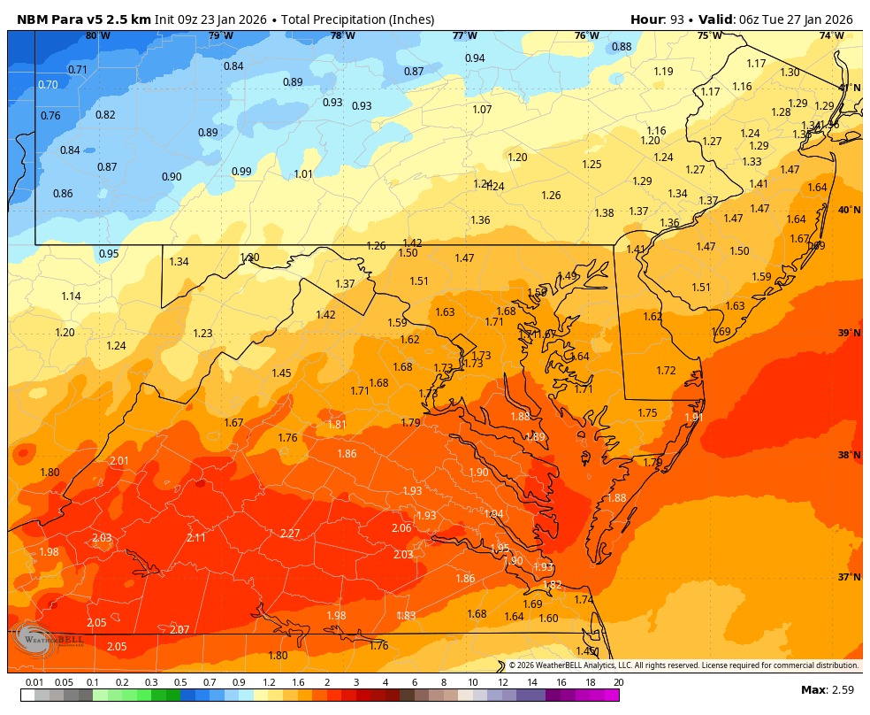
WB 9Z NBM para


-

“Cory’s in LA! Let’s MECS!” Jan. 24-26 Disco
WxWatcher007 replied to TheSnowman's topic in New England
As an aside, look at that high nosing into the central U.S. Beautiful -

Possible Record Breaking Cold + Snow Sunday 1/25 - Tuesday 1/27
nycwinter replied to TriPol's topic in New York City Metro
snow and sleet will stick around for awhile with high temps next week in the 20's and lows in the low teens at night. -
-
It's only -1 here in Hammond/East Chicago. I know what's coming.
-
I honestly feel for them, counties with I75 from McMinn north are a coin flip on that map (ISW vs WWA).
-
y'all making the teachers in Knoxville nervous about having school on Monday lol
-
I'm going to hug this ensemble because it shows the most snow.
-

Possible Record Breaking Cold + Snow Sunday 1/25 - Tuesday 1/27
jdj5211 replied to TriPol's topic in New York City Metro
Steven’s thoughts…. . -

Possible Record Breaking Cold + Snow Sunday 1/25 - Tuesday 1/27
Stormlover74 replied to TriPol's topic in New York City Metro
This is starting to remind me of that storm in Dec 2013 where we went from teens and snow over to sleet. It was a smaller storm but I remember the crazy temperature differential with like 13 in Sussex and 44 and rain in AC -

January 25-26 Winter Storm Potential
MickeyTim6533 replied to Ralph Wiggum's topic in Philadelphia Region
I'm new to the boards, are you always this pessimistic? LOL -

Possible Record Breaking Cold + Snow Sunday 1/25 - Tuesday 1/27
jm1220 replied to TriPol's topic in New York City Metro
Yep, it will be hard as granite. The snowpack will contain the same water as anywhere else since we aren't transitioning to rain or going above freezing-it will just be denser near the coast. -
Possible Record Breaking Cold + Snow Sunday 1/25 - Tuesday 1/27
Stormlover74 replied to TriPol's topic in New York City Metro
It can overdo it. We're flipping regardless but hopefully can get a bigger front end thump like the other models have. Problem is we still have 48 hours to go -
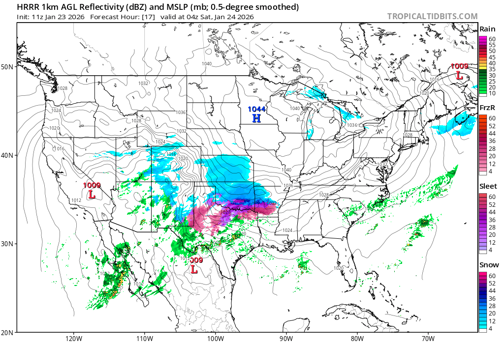
Hrrr only 17hrs from now out storm will have blossomed

-
-13 here and still dropping. Dew is down to -25.
-
Possible Record Breaking Cold + Snow Sunday 1/25 - Tuesday 1/27
jm1220 replied to TriPol's topic in New York City Metro
Good thing I don't have to commute there. -

Possible Record Breaking Cold + Snow Sunday 1/25 - Tuesday 1/27
lee59 replied to TriPol's topic in New York City Metro
NYC has a chance to break their record of longest stretch of below 32 temperatures. -

Possible Record Breaking Cold + Snow Sunday 1/25 - Tuesday 1/27
NJwx85 replied to TriPol's topic in New York City Metro
The piles of black and yellow snow in Brooklyn are going to look great next week. -
As crazy this storm has been to track, who knows.
-
I think there is almost a diving line in the Lehigh Valley between who sees 8+ and who doesn’t when all the trending and everything is said and done. My expectations for Allentown/Bethlehem etc is these areas top out around 7/8in and then get dosed with slop
-

Possible Record Breaking Cold + Snow Sunday 1/25 - Tuesday 1/27
SnoSki14 replied to TriPol's topic in New York City Metro
We might set some modern snow pack longevity records with no warm ups in sight after the storm. That glacier will last a very long time -

Central PA Winter 25/26 Discussion and Obs
AccuChris replied to MAG5035's topic in Upstate New York/Pennsylvania
Excellent write up by NWS State College in their AFD: “All in all, the probability of snowfall amounts exceeding 12 inches has increased to 60-80 percent across much of central PA. The probability of more than 18 inches ranges from 15 to 40 percent. Amounts near 24 inches can`t be ruled out (10 percent chance) especially if the comma head sits over central PA Sunday night. Always prepare for the worst case scenario and continue to check the forecast as it evolves. Now is the time to prepare. Think snow blowers, re-arranging travel plans to avoid travel during the storm, what to do in case of a power outage, etc. Remember it will be very cold before, during and after the storm. Never run a generator indoors due to carbon monoxide. Now if you really enjoy meteorology and want to know *why* we are predicting the most significant accumulations in the past 5+ years, feel free to read on through the remainder of this KEY MESSAGE 2 discussion. We`ve had our fair share of cold snaps this winter season, and tomorrow (Friday) will be no exception after the next Arctic front pushes through. A large factor driving all this cold weather has been the Polar Vortex displaced from the North Pole, with a tendency for the vortex to find itself over Hudson Bay and northern Quebec. With displacement that far south, we`ve gotten plenty of cold air, but it`s also nudged the storm track south of our area for many of the recent events. If you`ve ever heard people say "it`s too cold to snow", it`s not that it`s physically too cold to snow, it usually just means that the storm track has shifted far enough to the south that we end up under dry high pressure while our temps are cold. One key difference this time is the influence of a Pacific storm, located off the coast of southern California this evening, and a strengthening subtropical jet to its south. Over the next 24 hours these features will cross the Baja Peninsula of Mexico and then into Texas. Southwesterly flow out ahead of this southern stream feature will pump warmer air into the Gulf Coast and Southeastern US Saturday night into Sunday. At the same time, a northern stream shortwave trough coming down from western Canada into the Great Plains will bring a reinforcing shot of cold air to the back side of the northern longwave trough. The increasing temperature gradients will result in an overall increase in wind speed aloft at jet stream altitude, and an amplification of the northern stream trough and ridge. By Sunday, the right entrance region of the northern jet and the left exit region of the southern jet will align to produce enhanced upward motion through the troposphere. Remaining uncertainty in the forecast largely depends on the degree of phasing of these two jets, the angle at which they align, and how much amplification there is of the ridge out ahead of the deepening trough. The very cold air in place ahead of this system also plays other crucial roles to increase impacts. At 00Z Sunday, model consensus depicts a 1040+ mb high over New York State, which only slowly moves northeastward across New England over the next 24 hours. The deep, cold blocking high to the northeast of a winter storm is a textbook feature that supplies a stream of cold air down the Alleghenies and provides a cold dome for warmer, less dense air parcels streaming in from the southwest to ascend over. That upward motion is key to production of hydrometeors - in this case snow. And then there is the key role that cold temperatures have on ice crystal habits. The so called "dendritic growth zone" exists where temperatures are between roughly 0F and 10F. Given low temperatures Saturday night in the single digits, some spots might start off with a DGZ that extends from the ground up 10,000 to 15,000 feet which is pretty remarkable for a large synoptic storm in this region. As long as the column saturates quickly enough, any snow that falls late Saturday night and into early Sunday morning could be very high ratio, fluffy, rapidly accumulating snow that consists of many pristine dendrites (SLRs 15-20:1, could be even higher if the column saturates faster but there is dry air at low levels to overcome at onset). So after a few hours of virga, accumulations have the potential to begin with a vengeance in the predawn hours Sunday, especially from I-80 south.” . -

Possible Record Breaking Cold + Snow Sunday 1/25 - Tuesday 1/27
BoulderWX replied to TriPol's topic in New York City Metro
NAM should give pause. I hate the model but I think it’s very good at detecting warm noses.