All Activity
- Past hour
-
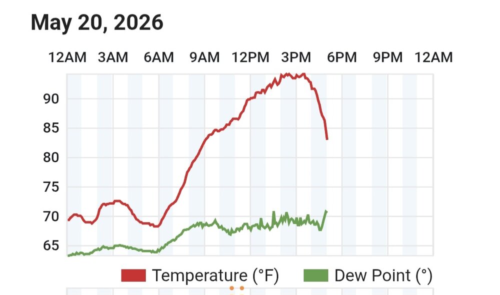
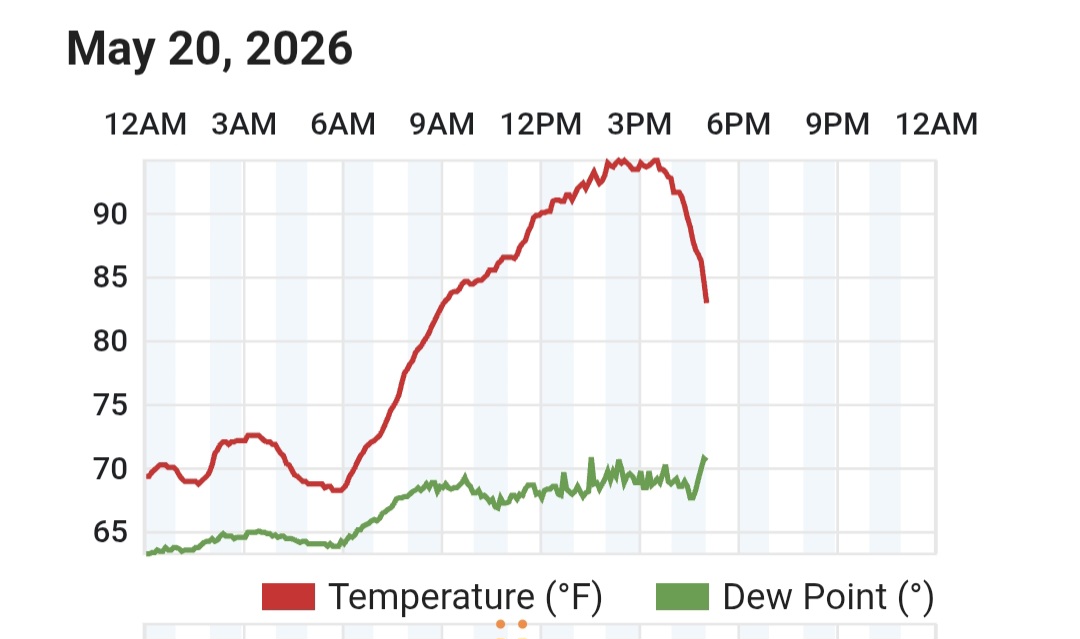
Kind of a fun temperature graph. There was no local storm responsible for the drop, although the nearby ones definitely helped. DP up around 70 though non é buono.
-
Dew down to 43F. Going to be quite the reversal of the past couple days when it’s mid-50s for highs tomorrow in sunshine. Tonight Partly cloudy. Lows in the upper 30s. Northwest winds 10 to 15 mph with gusts up to 25 mph. Thursday Partly sunny in the morning, then clearing. Highs in the mid 50s. Northwest winds around 10 mph. Thursday Night Mostly clear. Areas of frost after midnight. Lows in the lower 30s. Light and variable winds.
-
Disappointed.
-
Down 26 degrees from our high temp.
-

E PA/NJ/DE Spring 2026 Obs/Discussion
RedSky replied to PhiEaglesfan712's topic in Philadelphia Region
Wicked gusts heavy downpours zero lightning -

2026-2027 Strong/Super El Nino
snowman19 replied to Stormchaserchuck1's topic in Weather Forecasting and Discussion
-
Oh... ok Severe Weather Statement National Weather Service Charleston WV 506 PM EDT Wed May 20 2026 WVC015-039-087-202130- /O.CON.KRLX.SV.W.0084.000000T0000Z-260520T2130Z/ Kanawha WV-Roane WV-Clay WV- 506 PM EDT Wed May 20 2026 ...A SEVERE THUNDERSTORM WARNING REMAINS IN EFFECT UNTIL 530 PM EDT FOR NORTHEASTERN KANAWHA...SOUTH CENTRAL ROANE AND WEST CENTRAL CLAY COUNTIES... At 505 PM EDT, a severe thunderstorm was located over Clendenin, or 15 miles west of Clay, moving east at 30 mph. THIS IS A DESTRUCTIVE STORM FOR Clendenin. HAZARD...Baseball size hail and 70 mph wind gusts. SOURCE...Radar indicated. IMPACT...People and animals outdoors will be severely injured. Expect shattered windows, extensive damage to roofs, siding, and vehicles. Locations impacted include... Clendenin, Elkview, Amma, Glen, Pinch, and Left Hand. PRECAUTIONARY/PREPAREDNESS ACTIONS... A tornado watch remains in effect for the warned area. Tornadoes can develop quickly from severe thunderstorms. Although a tornado is not immediately likely, if one is spotted act quickly and move to a place of safety inside a sturdy structure, such as a basement or small interior room. For your protection move to an interior room on the lowest floor of a building. Torrential rainfall is occurring with this storm, and may lead to flash flooding. Do not drive your vehicle through flooded roadways. && LAT...LON 3842 8153 3855 8158 3862 8124 3836 8119 TIME...MOT...LOC 2105Z 249DEG 26KT 3850 8136 THUNDERSTORM DAMAGE THREAT...DESTRUCTIVE HAIL THREAT...OBSERVED MAX HAIL SIZE...2.75 IN WIND THREAT...OBSERVED
-
That's it. Put that marketing degree to work. Occasional rumbles of thunder here, but only a few moments of insignificant rain so far. We maxed at 94⁰ here. Down to 81 now.
-

E PA/NJ/DE Spring 2026 Obs/Discussion
JTA66 replied to PhiEaglesfan712's topic in Philadelphia Region
Big gusts coming through, power flickering. -
I wish there was a climo station in town either on the NCSU campus or at one of the city parks.
-
Decent rains, thunder and lightning.
-
The radar is showing oranges here and yet, under the patio table is still dry.
-

E PA/NJ/DE Spring 2026 Obs/Discussion
CoolHandMike replied to PhiEaglesfan712's topic in Philadelphia Region
My mom just confirmed pea-sized hail in Oxford, near Lincoln University: -
All I want is a good storm. Folks back home been getting the goods all spring.
-
Lame here
-
Went for a bike ride down here in Brick. Absolutely brutal out, but there's a breeze at least. Now I'm ready for the storms to roll in.
-
91.7 for the day
-
outflow hit. but radar is doo doo south of I-66 east towards the potomac
-

Central PA Spring 2026 Discussion/Obs Thread
Jns2183 replied to Voyager's topic in Upstate New York/Pennsylvania
.02". This area continues it's struggles when lots of others cash in. It's funny looking at 60 month maps and seeing a bullseye Sent from my SM-S731U using Tapatalk -
E PA/NJ/DE Spring 2026 Obs/Discussion
CoolHandMike replied to PhiEaglesfan712's topic in Philadelphia Region
And just like that: -
With the outflow boundary out racing a lot of the convection, this has probably ended any scattered or widespread risk for wind damage. Looks more like generic thunderstorms for the rest of the evening.
-
Raining pretty good in northern Mclean
-
Yeah maybe beyond that, too.
-
Managed to sneak in 90.0. 4 day heatwave in the books.
-
Wind picked up STRONG over at Coppin. Walking across a parking lot was an adventure.


.thumb.gif.f92b16c631a1d15d405ed77b33f0710d.gif)

