All Activity
- Past hour
-
 Tomorrow night could be really fun, could even be more fun if that EML wasn't shunting to our southwest
 -
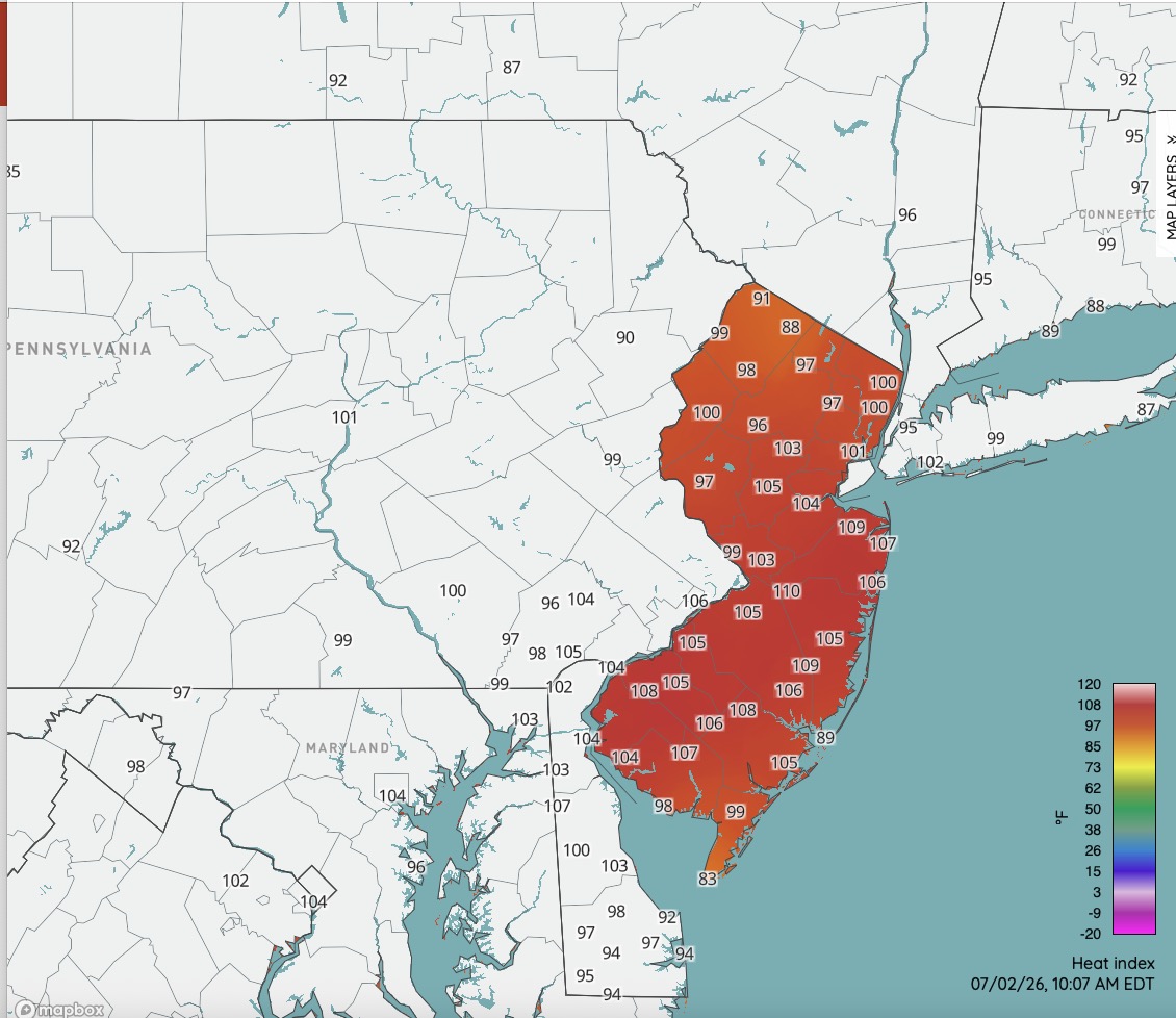
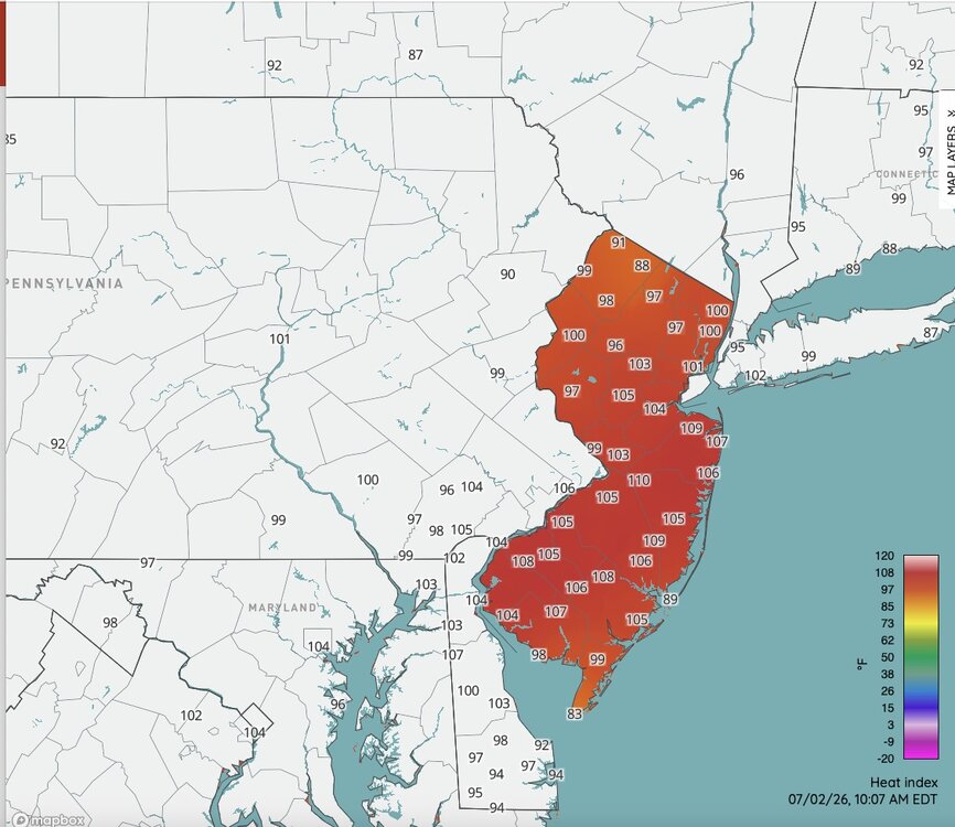
Nasty hot already. DP's will mix out some later but with temperatures 100-105 for most away from the immediate NJ shore the heat index readings this afternoon could reach 115+ across much of NJ. Approaching rare territory at those ranges.
-
One more warmer day then back to reality along the shore.
-
There shall be no struggle to reach 100 today I suspect. BWI is already at 93. I wouldn’t be surprised to see 103-104 in some areas. Stations over here east of 15 in S PA/N MD are torching.
-
 90 at Shirley right next door, but 88/73 here at 10am. Some 90 .. 91 sprinkled in a sea of 87 to 89s Solid recovery out of the overnight outflow wash
 -
FAIL! Overcooked highs.
-

Central PA Summer 2026 Discussion/Obs Thread
canderson replied to Voyager's topic in Upstate New York/Pennsylvania
Sunday we have a chance of rain. But like it has for 5 months the close we get the more south that’ll sink. -
 10am 85.3/76 at WXW1 91/70 at HFD 78/67 at SLK 75.0/70 at WXW2
 -
A general rule of thumb in heat situations like this is add 10F to the 10am temp at DCA for its high and it’s at 92 at 10am
-
 Are typhoons in the Pacific linked to increased subtropical jet stream activity… ie. more rain in the South and East?
 -
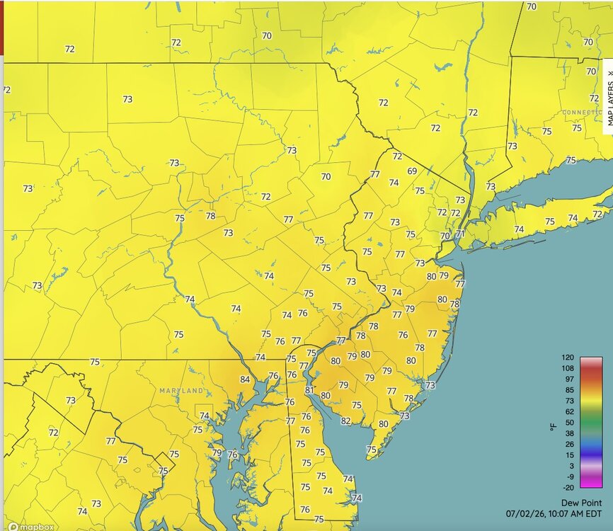
Newark is currently 3° cooler at 10am. SXUS51 KOKX 021357 OSOOKX New York City Metropolitan Area Weather Roundup National Weather Service New York NY 1000 AM EDT THU JUL 02 2026 CITY SKY/WX TMP DP RH WIND PRES REMARKS Central Park SUNNY 91 71 51 W6 30.02S HX 97 LaGuardia Arpt MOSUNNY 90 69 50 NW10 29.98R HX 94 Kennedy Intl MOSUNNY 96 69 41 NW10 29.99R HX 102 Newark Liberty MOSUNNY 95 69 42 W9 29.99S HX 100 Teterboro Arpt SUNNY 93 71 48 VRB6 29.98S HX 100 Bronx Lehman C N/A 90 70 51 NW7 N/A HX 95 Queens College N/A 91 68 46 N10 N/A HX 95 Breezy Point N/A 82 N/A N/A W7 N/A Brooklyn Coll N/A 91 68 46 N8 N/A HX 95 Staten Island N/A 93 70 46 NW5 N/A HX 99
-
Brownsville recorded 100 per Mesonet
-
Yup. I remember the heat waves in Philly during the 90s. The air was brown and it smelled like ash or batteries (ozone?). Just the worst.
-
96 at jfk already with a NW wind. That site goes nuclear when the wind is offshore .
-

E PA/NJ/DE Summer 2026 Obs/Discussion
MGorse replied to PhiEaglesfan712's topic in Philadelphia Region
These dew points are just awful! -
Super hazy. But note that it’s sunny, hazy, hot and humid as shit, and we don’t have air quality alerts. Pollution control works! We should keep doing it!
-

Central PA Summer 2026 Discussion/Obs Thread
Itstrainingtime replied to Voyager's topic in Upstate New York/Pennsylvania
Elliott also offers this: The SPC has placed southeastern PA & the LSV in a "slight risk" for #severewx on Fri, but I strongly disagree. The "heat dome" will still be centered over the southern mid-Atlantic States. Beneath it, sinking motion will suppress T-storm formation. North of I-80, different story. -
 90 BDL
 -

2026-2027 Super El Nino
PhiEaglesfan712 replied to Stormchaserchuck1's topic in Weather Forecasting and Discussion
Even December 2001 was near record warm, so the cold period was really 2002-2010. Heck, you could even make the argument the cold period for December ended in 1989. Decembers from 1990 forward average 4 degrees warmer than the Decembers from 1960-1989 here at PHL. -
87/74 at 9:55. Outpacing yesterday by almost exactly one hour
-
86/73 already.
-
Agree. Its hot, don't get me wrong, but pretty ho-hum by IL standards.
-
Central PA Summer 2026 Discussion/Obs Thread
Itstrainingtime replied to Voyager's topic in Upstate New York/Pennsylvania
93/75 at 9:50am. Elliott says that west winds will lead to compressional heating this afternoon with dews settling into the 60s. With temps in the 100s the HI will be similar to yesterday. -

2026 Severe Wx - General Thread
SchaumburgStormer replied to largetornado's topic in Lakes/Ohio Valley
Was it Broyles? If it was, I am surprised we didn't get a PDS cumulus watch. -

E PA/NJ/DE Summer 2026 Obs/Discussion
Hurricane Agnes replied to PhiEaglesfan712's topic in Philadelphia Region
Ugh. Already 92 and it ain't even 10 am yet. Dewpoint sitting at 80.