All Activity
- Past hour
-
It forgot everything it learned earlier
-

Central PA Winter 25/26 Discussion and Obs
MickeyTim6533 replied to MAG5035's topic in Upstate New York/Pennsylvania
ICON is horrific -
It had that northern stream component notably West early on into the run like NAM and Euro, but then yeah the entire look fell apart.
-
ICON is laughably terrible btw
-
One thing to note is the DGZ is going to be very close to the surface. The difference in solutions run to run is dependent upon where the 850 vort passes when dropping south out of Canada. If the winds veer at 850 from the NW instead of N, NNE then the lift mechanism needed would be the mountains/plateau. Moisture is in place, just need something to lift the parcels.
-

Possible coastal storm centered on Feb 1 2026.
UnitedWx replied to Typhoon Tip's topic in New England
That's... unfortunate -

The “I bring the mojo” Jan 30-Feb 1 potential winter storm
BooneWX replied to lilj4425's topic in Southeastern States
Icon is following the NAM (I know), west, with our northern stream. Keep playing around with that look, you’ll drop the wave somewhere around Arkansas and instead of your late bloomer, you get a gulf low -
Possible coastal storm centered on Feb 1 2026.
UnitedWx replied to Typhoon Tip's topic in New England
Fixed -

The “I bring the mojo” Jan 30-Feb 1 potential winter storm
WarmNoseHater replied to lilj4425's topic in Southeastern States
it's really going to be something to see how a warm nose works its way into this one, but i won't sell mother nature short in the carolinas -

Possible coastal storm centered on Feb 1 2026.
NoCORH4L replied to Typhoon Tip's topic in New England
He's a famous musician who has to go and perform -
I am very happy you are okay. You'll get the windshield fixed, but the most important thing is you are okay.
-
Bf is gonna do a special 6z umbrella launch for the 6z runs.
-
 6.3" at ~40:1?! Insane What are the best ratios you've seen up there for a >6" measurement?
 -

2025-2026 Fall/Winter Mountain Thread
Buckethead replied to Buckethead's topic in Southeastern States
-3.8 with snow still pouring sideways in Wolf. Sent from my Pixel 10 Pro using Tapatalk -
 3.6” new most of that on one hour. 22.9”
 -

The “I bring the mojo” Jan 30-Feb 1 potential winter storm
BornAgain13 replied to lilj4425's topic in Southeastern States
This is how I feel about the models tonight
-
Possible coastal storm centered on Feb 1 2026.
UnitedWx replied to Typhoon Tip's topic in New England
Sorry, but why the f**k would anyone want to go to the Grammys? Talk about a bunch of Just fly back early -
When are we getting recon data for the shortwave in the Pacific? Once that’s ingested into the modeling dataset, it’s going to make alllll the difference…
-
Back to back 14 day stretch I can’t think of one except maybe 1977
-
-
 Moon visible now with flurries ending. Final core is 2.0”/0.05”….so that’s 6.3”/0.16” since I snowblowed this morning. Event total 15.5”/1.01”
 -

The “I bring the mojo” Jan 30-Feb 1 potential winter storm
Coach McGuirk replied to lilj4425's topic in Southeastern States
Potential coastal low this weekend. It will be cold enough. -
10-14” on their 730am report. I’m convinced that if you add up the lower number of Jay’s range you’d get their actual annual snowfall.
-
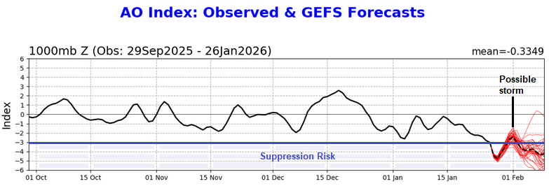
Based on the forecast teleconnections, a track that leads to impacts in the northern Mid-Atlantic/southern New England regions remains plausible. The PNA+ promotes an eastern trough and the AO- block can slow the system. With the AO rising rapidly, but remaining strongly negative, the risk of suppression is reduced over what it would be were the AO to be at or below -3.000 and falling. An out-to-sea or only grazing solution remains possible, but a solution that has at least some impacts remains more likely than a purely out-to-sea solution. IMO, the 1/26 18z ECMWF-AIFS provides a plausible outcome. It also has support from the NBM's probabilities. Currently the storm and its development remain beyond the range of the models' capability to skillfully resolve the synoptic details that will lead up to the possible event. Until then, the broader longwave pattern and its evolution offer insight. At this lead time, storm formation seems to be a reasonable scenario. A coastal or out-to-sea track are both realistic possibilities with the former still looking more likely than the latter. By Wednesday or perhaps Thursday, there should be greater consensus on the outcome, especially as the guidance will be starting to resolve the all-important synoptic details. For now, a moderate- or high-impact storm remains on the table.
-

Snow Contest January 25th-26th
Roger Smith replied to WeatherGeek2025's topic in New York City Metro
If we're going pro, I am going to be Don's caddy.