All Activity
- Past hour
-

2026 Mid-Atlantic Severe Storm General Discussion
Eskimo Joe replied to Kmlwx's topic in Mid Atlantic
Decent velocities on that line approaching Garrett County. Might be an overperformer today west of I-95. -
Watch up till 9pm for entire LWX CWA except St. Mary's
-
Have they changed the criteria for a heat advisory? I noticed it says 2 consecutive days of real feel of 95-99 is all it takes now. The past 2 days have been hot but not really where I would've expected to be under an advisory
-
 http://mapletrustrx.com/# canadian drugs online
 -
Or now... watch coming soon https://www.spc.noaa.gov/products/md/mcd1896.png Mesoscale Discussion 1896 NWS Storm Prediction Center Norman OK 1159 AM CDT Mon Aug 10 2026 Areas affected...the Maryland and West Virginia Panhandles into the Delmarva Concerning...Severe potential...Watch likely Valid 101659Z - 101900Z Probability of Watch Issuance...80 percent SUMMARY...The threat for locally damaging winds is expected to increase this afternoon, likely requiring a severe thunderstorm watch issuance. DISCUSSION...Daytime heating combined with boundary-layer dewpoints in the upper 60s to lower 70s has contributed to a moderately unstable air mass as of early afternoon with steepening low-level lapse rates and MLCAPE of 1500-2500 J/kg. Upstream convection over southwest PA is gradually developing a tighter leading-edge reflectivity gradient and more robust trailing stratiform region, suggestive of an organizing cold pool. Current thinking is that the evolving convective system will further intensify as it continues east-southeast and encounters an increasingly unstable environment across the discussion area. The current KPBZ VWP is sampling strengthening west-northwest flow above 2 km AGL, which will likely aid in further cold pool organization. These factors will lead to an increasing threat for damaging wind gusts across the area this afternoon, likely requiring the issuance of a severe thunderstorm watch. ..Mead/Hart.. 08/10/2026 ...Please see www.spc.noaa.gov for graphic product... ATTN...WFO...PHI...AKQ...LWX... LAT...LON 39117919 39457922 39687831 39607644 39657577 39167542 38627575 38367675 38547793 38717879 38877919 39117919 MOST PROBABLE PEAK WIND GUST...55-70 MPH MOST PROBABLE PEAK HAIL SIZE...UP TO 1.25 IN
-

Augdewst 2026: Summer's Last Stand
weatherwiz replied to Prismshine Productions's topic in New England
Just makes it easier to get inside once you start getting that "bad" feeling -

Augdewst 2026: Summer's Last Stand
Cyclone-68 replied to Prismshine Productions's topic in New England
No t-storms and absolutely nothing going on in the tropics makes this summer unbelievably boring. -
Fringed
-

Augdewst 2026: Summer's Last Stand
Damage In Tolland replied to Prismshine Productions's topic in New England
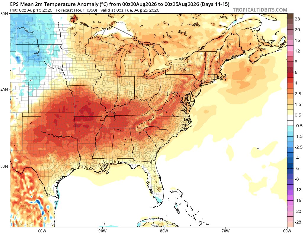
Summer is far, far from over . Dews are back next week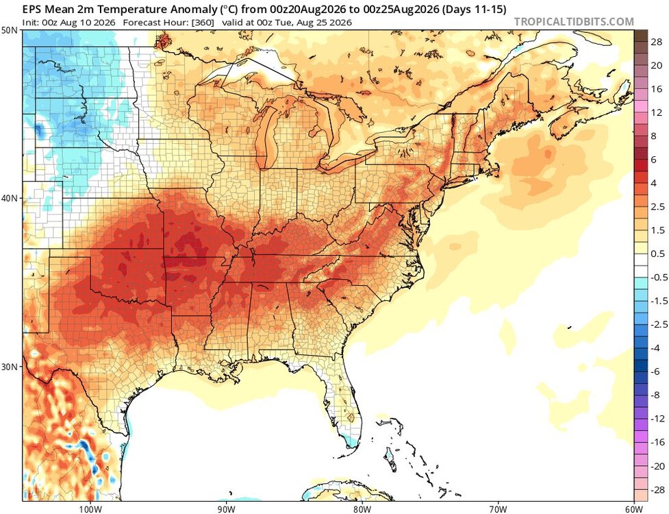
-
I'm guessing a MCD for us by 230pm
-

Central PA Summer 2026 Discussion/Obs Thread
mahantango#1 replied to Voyager's topic in Upstate New York/Pennsylvania
SEVERE THUNDERSTORM WATCH OUTLINE UPDATE FOR WS 553 NWS STORM PREDICTION CENTER NORMAN OK 1225 PM EDT MON AUG 10 2026 SEVERE THUNDERSTORM WATCH 553 IS IN EFFECT UNTIL 700 PM EDT FOR THE FOLLOWING LOCATIONS PAC001-015-037-041-043-055-067-069-071-075-079-093-097-099-107- 109-115-119-127-131-133-102300- /O.NEW.KWNS.SV.A.0553.260810T1625Z-260810T2300Z/ PA . PENNSYLVANIA COUNTIES INCLUDED ARE ADAMS BRADFORD COLUMBIA CUMBERLAND DAUPHIN FRANKLIN JUNIATA LACKAWANNA LANCASTER LEBANON LUZERNE MONTOUR NORTHUMBERLAND PERRY SCHUYLKILL SNYDER SUSQUEHANNA UNION WAYNE WYOMING YORK $$ -
https://trustpharmaindia.com/# cheapest online pharmacy india
-

2026 Mid-Atlantic Severe Storm General Discussion
wxmeddler replied to Kmlwx's topic in Mid Atlantic
The squall line pushing across PA looks healthy.- 1,764 replies
-
- 1
-

-
- severe
- thunderstorms
- (and 7 more)
-

Augdewst 2026: Summer's Last Stand
Go Kart Mozart replied to Prismshine Productions's topic in New England
I have to ask...what's the point of standing near the car with the door open? Are you planning on jumping into the car before the bolt strikes? -
Augdewst 2026: Summer's Last Stand
Damage In Tolland replied to Prismshine Productions's topic in New England
Yeah nothing doing SNE tonight or the next week. Stein back -

Augdewst 2026: Summer's Last Stand
CT Valley Snowman replied to Prismshine Productions's topic in New England
Zzzzzzzzzz -
But the drought!?! /s
-
-
Like the other day, this area has likely laid down subtle boundaries across nrn VA and cntrl MA, perhaps providing local focus for storms later.
- 1,764 replies
-
- 1
-
-
- severe
- thunderstorms
- (and 7 more)
-

2026 Atlantic Hurricane Season
vortex95 replied to Stormchaserchuck1's topic in Tropical Headquarters
The ITCZ is suppressed by a few deg farther S than normal for this time of year. That is generally a sign things are not good in the MDR. -
lots of sun this morning, feels juiced af even with the light e winds
- 1 reply
-
- 1
-
-
2026 Atlantic Hurricane Season
vortex95 replied to Stormchaserchuck1's topic in Tropical Headquarters
And one thing that has made its presence known the last few years is the TUTT! And we have them here once again quite apparent in the fcst. -
And 2% tor
-

Central PA Summer 2026 Discussion/Obs Thread
canderson replied to Voyager's topic in Upstate New York/Pennsylvania
Picked up .15” this am. -
Good , we don’t need anymore rain