All Activity
- Past hour
-
Because danger to and destruction of others’ property and lives gives you a thrill. Got it, and “whining like a child” when it stays ots. Sheesh. Barry GBP would be proud of you. Right, Barry? Barry?
-

Spooky Season (October Disco Thread)
Go Kart Mozart replied to Prismshine Productions's topic in New England
lock it in....
-
Complete and utter garbage...if you do a search on youtube, every year is the same nonsense with the blood-red "worst of winter" designation lurking somehere near the east coast.
-
Rain is hanging around this am in the Triangle. I’m glad we needed it, hope it soaks all day.
-
Too early for any winter forecast right now. The past few years proved that winter outlooks are fickle this far out .
-
At least they're well, predictable . Every year my circle of friends see these and ENDLESSLY ask me to watch them and give my opinion... I don't have to watch to let them know my opinion. "but he makes such good points" yeah, rigghhhtttt
-

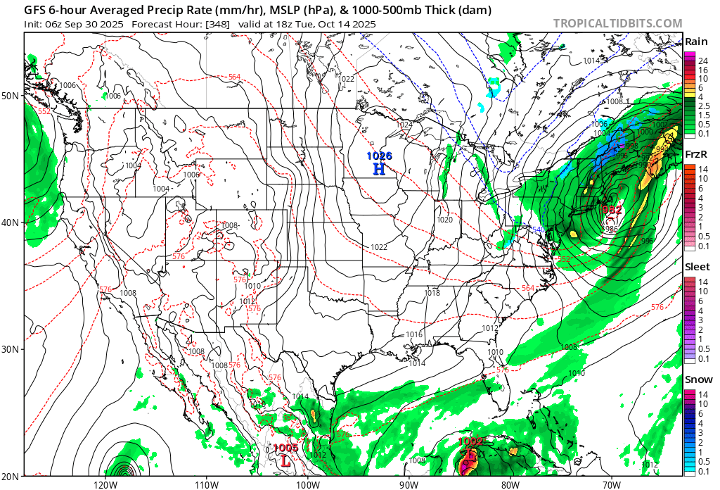
2025-2026 ENSO
40/70 Benchmark replied to 40/70 Benchmark's topic in Weather Forecasting and Discussion
It is a decent analog in general, but if the PNA is that negative again, I'll shave anthonymm into my crotch and post pics. That season with tamer RNA would be pretty good....the reason December had "no good storms" Is because the extreme RNA turned the pre XMAS east coast blizzard into a cutter when it it was forced to phase with the PV too far west. We also wasted what would have been a great March pattern because of the unfavorable west Pac working in conjunction with the severe RNA....get those areas a bit less hostile and it would have been good further south. -
locked in

-
Woke up to good steady rain. Hopefully this continues for a bit. Much much needed
-
2025-2026 ENSO
40/70 Benchmark replied to 40/70 Benchmark's topic in Weather Forecasting and Discussion
If you look at all of the record fall negative PDO seasons, they all rise precipitously throuought winter......a severely negative PDO all but ensures it rises. Maybe I wasn't clear enough...I am not saying the PDO will flip positive this winter, but rather it will be elevating steadily, which probably leads to some decent periods of PNA. -
That Direct Weather site is brutal....all he does is hype and basically narate seasonal guidance.
-

Central PA Fall Discussions and Obs
Mount Joy Snowman replied to ChescoWx's topic in Upstate New York/Pennsylvania
62 when I left the house. Carry on. -

Spooky Season (October Disco Thread)
HoarfrostHubb replied to Prismshine Productions's topic in New England
Monday should be the warmest for a while. Mid 80s possible. - Today
-

September 2025 OBS-Discussion centered NYC subforum
bluewave replied to wdrag's topic in New York City Metro
This was still the warmest last week of September for many across the region. Time Series Summary for SOMERSET AIRPORT, NJ Click column heading to sort ascending, click again to sort descending. 1 2025-09-30 71.2 1 2 2011-09-30 70.3 0 3 2017-09-30 69.4 0 4 2010-09-30 69.3 0 5 2015-09-30 67.0 0 6 2007-09-30 66.8 0 7 2020-09-30 66.5 0 8 2024-09-30 66.1 0 - 2019-09-30 66.1 0 9 2004-09-30 65.0 0 10 2014-09-30 64.4 0 Time Series Summary for SUSSEX AIRPORT, NJ Click column heading to sort ascending, click again to sort descending. 1 2025-09-30 69.4 1 2 2011-09-30 68.6 0 3 2010-09-30 66.9 0 4 2017-09-30 66.3 0 5 2020-09-30 65.1 0 6 2007-09-30 64.8 0 7 2024-09-30 64.5 0 8 2014-09-30 64.3 0 9 2015-09-30 63.5 0 10 2019-09-30 62.6 0 Time Series Summary for New Brunswick Area, NJ (ThreadEx) Click column heading to sort ascending, click again to sort descending. 1 2025-09-30 73.2 1 2 2017-09-30 72.0 0 3 2011-09-30 71.8 0 4 1959-09-30 71.6 0 - 1920-09-30 71.6 0 5 2010-09-30 71.2 0 6 1945-09-30 71.0 0 7 1933-09-30 70.5 0 8 1923-09-30 69.9 0 9 1910-09-30 69.8 2 10 1970-09-30 69.5 0 Time Series Summary for NEWARK LIBERTY INTL AP, NJ Click column heading to sort ascending, click again to sort descending. 1 1881-09-30 77.5 0 2 2025-09-30 75.0 1 3 1959-09-30 73.3 0 4 2011-09-30 73.1 0 5 2010-09-30 72.6 0 6 1986-09-30 72.1 0 7 2017-09-30 72.0 0 8 1920-09-30 71.1 1 9 2007-09-30 70.5 0 10 2019-09-30 70.4 0 - 1968-09-30 70.4 0 - 1933-09-30 70.4 0 Time Series Summary for WESTCHESTER CO AP, NY Click column heading to sort ascending, click again to sort descending. 1 2025-09-30 71.0 1 2 1959-09-30 70.9 0 3 2011-09-30 69.5 0 4 2017-09-30 69.1 0 5 1970-09-30 69.0 0 6 2010-09-30 68.7 0 7 2007-09-30 67.6 0 8 1986-09-30 66.9 0 9 1968-09-30 66.7 0 10 2020-09-30 66.6 0 Time Series Summary for JFK INTERNATIONAL AIRPORT, NY Click column heading to sort ascending, click again to sort descending. 1 2025-09-30 72.5 1 2 1959-09-30 72.4 0 3 2011-09-30 71.7 0 4 2010-09-30 71.6 0 5 2017-09-30 70.9 0 6 1986-09-30 69.8 0 7 1968-09-30 69.6 0 8 2007-09-30 69.2 0 9 2015-09-30 69.1 0 10 2020-09-30 68.9 0 Time Series Summary for LAGUARDIA AIRPORT, NY Click column heading to sort ascending, click again to sort descending. 1 2025-09-30 74.5 1 2 1959-09-30 74.3 0 3 2007-09-30 73.8 0 4 2010-09-30 73.7 0 5 2011-09-30 72.1 0 6 2017-09-30 72.0 0 7 2020-09-30 71.9 0 8 1986-09-30 71.7 0 9 2019-09-30 71.4 0 10 1968-09-30 69.7 0 - 1945-09-30 69.7 0 Time Series Summary for ISLIP-LI MACARTHUR AP, NY Click column heading to sort ascending, click again to sort descending. 1 2025-09-30 74.0 1 2 2010-09-30 71.1 0 3 2011-09-30 70.7 0 4 2017-09-30 69.6 0 5 2007-09-30 68.1 0 6 2020-09-30 68.0 0 - 1986-09-30 68.0 0 8 2015-09-30 66.9 0 9 1972-09-30 66.4 0 10 2019-09-30 66.3 0 11 2014-09-30 65.9 0 Time Series Summary for NEW HAVEN TWEED AP, CT Click column heading to sort ascending, click again to sort descending. 1 2025-09-30 72.1 1 2 2011-09-30 71.5 0 3 2010-09-30 71.2 0 4 1970-09-30 70.4 2 5 1959-09-30 69.9 0 6 2020-09-30 69.1 0 7 2017-09-30 67.9 0 8 2019-09-30 67.0 0 - 2007-09-30 67.0 0 10 2024-09-30 66.1 0 11 2014-09-30 65.5 0 -
It’s been a real long time since we’ve seen a true predominant +EPO winter. Honestly since 11-12. Ever since then we default to -EPO several times during the winter and haven’t really seen a +EPO “lock in” like that since
-
The “warm blob” has been taking a big hit over the last few weeks. Now the question becomes does it come back by December (i.e. 2013)? Or do we see a classic “cold horseshoe” negative PDO alignment develop like Paul Roundy thinks is going to happen?
-
Downtown Brattleboro was also spectacular, but I didn't dig out my camera. I was on my way to an appointment. I just soaked it in.
-
 DCA _NYC _BOS _ ORD _ATL _IAH __ DEN _PHX _SEA 2.3 2.4 2.5 2.0 1.8 2.3 1.0 0.7 0.4
 -
0.53” for the event so far, 0.78” MTD
-

E PA/NJ/DE Autumn 2025 Obs/Discussion
LVblizzard replied to PhiEaglesfan712's topic in Philadelphia Region
Aurora is out tonight…too bad it’s freaking cloudy. Ugh. -

Fall/Winter Banter - Football, Basketball, Snowball?
John1122 replied to John1122's topic in Tennessee Valley
These overtime games are stressing me to the max, but it's not as bad as it was a few years ago now that you have basically two losses to play with each season. That said, even though Miss State is much improved, we would have won probably be 3 scores if the calls were correct on the pi's and we could catch a football while wide open. -
I mean, I wouldn't bet on the Ravens https://www.cbssports.com/nfl/news/nfl-super-bowl-odds-updates-how-much-did-ravens-move-after-1-3-start-lamar-jackson-injury/ 3 Good WR's, 2 good TE's, Henry and Lamar though.. Justice Hill, Mitchell. it seems to be clicking too. I guess Vegas likes highly powered offenses. High betting odds also means that Lamar's injury probably isn't serious
-
I've heard that towns that were just east of the eye fared the worst in Gloria, so probably places from Bay Shore out to the Hamptons had a lot of trees down. West side of the storm got the most rain, over 5.5 inches in NYC.
-

September 2025 OBS-Discussion centered NYC subforum
winterwarlock replied to wdrag's topic in New York City Metro
80 for a high 7th day in a row of 80 and above -
Funny you say that. We definitely had the 'eye' and I had remembered the warnings from the elders (lol) that once that eye went through it was going to be just as bad again, but the skies pretty much stayed blue as you say. Still the best sustained winds I've ever witnessed, but as years go by I wonder if Sandy was worse, simply because so many more trees went down, even given so many had already been culled by Gloria, the 2010 extended heavy rain/wind event, and Irene leading up to it. What towns do you think fared the worst on LI w/Gloria? I'd always heard it was Massapequa/Amityville. Tobay Beach right on the Nassau Suffolk border seemed like it lost half its sand when we returned the next summer. Went from an endless beach to one where there was little room in spots between the shore and the dunes. It was never the same. To me that was the biggest impact of the storm.