All Activity
- Past hour
-

Mid to long range discussion- 2025
WinstonSalemArlington replied to wncsnow's topic in Southeastern States
November 11 -
The short and sharp shot of cold looks good. Probably mid (maybe low) 30s for lows in the City, well into the 20s outside (teens in the coldest spots).
-
I saw that on Radar yesterday. Knew we were getting shafted.
-
His LinkedIn is pretty easy to see that he has no schooling for Meteorology but happened to have 1 job for 18 months working as one.
-
It pretty much rained all day and became moderate in the afternoon.
-

November 2025 general discussions and probable topic derailings ...
WinterWolf replied to Typhoon Tip's topic in New England
No, it’s been confirmed by the Pope. He was sure. He was adamant of a torch. -
Yeah. And I wouldn't ever expect wall to wall cold in November. The mean jet is historically to our north and its undulations deliver alternating cool and warm shots. But in a warming climate regime, I'm happy for every seasonal cold shot we get.
-
Looks like we get a shot of warmer air after that, but the average temps are becoming cooler this time of year now so above normal can still be in 50s by the time mid month comes.
-
Is a +WPO common during a Nina Autumn? Without looking into it, I feel like we usually see low heights out there during a Nina Autumn which helps with the common mild October we so often experience in a Nina.
-
European even has not one but two chances for flurries next week! Obviously a long ways away and whatnot but still cool to see.
-
You do realize that Dr. Sacoransky is an intern radiologist and not a met? Not that one needs to be a met to post about weather as we all know, but you post him often as gospel it seems.
-

Fall 2025 Medium/Long Range Discussion
A-L-E-K replied to Chicago Storm's topic in Lakes/Ohio Valley
euro looks relatively wet/active in the extended -
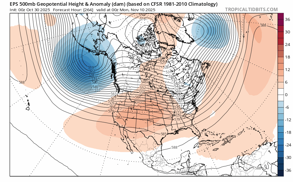
Inter-model guidance still showing a nice cool shot around Nov. 10-12. We'll see if it holds.
-
The GFS is the only model showing any real snow this weekend around here, but all models show the first big push of arctic air. It looks brief, however.
-
 Will there be deer blow downs?
 -
Once again, @WxUSAF is absolutely correct to be concerned about "wasting patterns", but it's somewhat comforting to see things slowly trending cooler as we near our first shot of late autumn weather. Not only more expansive cold, but better negative anamolies. EDIT: Euro also showing this too!
-

2025-2026 ENSO
brooklynwx99 replied to 40/70 Benchmark's topic in Weather Forecasting and Discussion
kind of a wild trend. hopefully we see more of this in the coming months... it's getting far enough into autumn that it holds a bit of weight. we saw the same -NAO trends last winter
-

November 2025 general discussions and probable topic derailings ...
CoastalWx replied to Typhoon Tip's topic in New England
How many hunters will be blown out of their tree stands? -

Correlation of extreme hurricanes, AGW, and solar cycles
WolfStock1 replied to WolfStock1's topic in Climate Change
Is there actually increased solar energy during the peaks of the cycle? From all I've seen those peaks are the peak of *activity* (magnetic fluctuations resulting in sunspots), not actually energy peaks. Wouldn't the actual solar energy received by the earth be *lower* during periods of peak sunspot activity? (Given that a sunspot is a "cool spot" where less energy is being output) I know there are more CMEs during the peaks, resulting in more-frequent aurora peaks; but it seems like that would be just noise in what might otherwise be a general lower level of overall energy from the sun. Not an expert on the subject - just putting out a "seems to me" theory. - Today
-
Occasional Thoughts on Climate Change
WolfStock1 replied to donsutherland1's topic in Climate Change
And yet worldwide life expectancy continues to rise. https://www.statista.com/statistics/805060/life-expectancy-at-birth-worldwide/ Something doesn't jive. Methinks it's the information in these "reports". (So much for the "good thing" of mass die-off) -

2025-2026 ENSO
40/70 Benchmark replied to 40/70 Benchmark's topic in Weather Forecasting and Discussion
+WPO. -
2025-2026 ENSO
40/70 Benchmark replied to 40/70 Benchmark's topic in Weather Forecasting and Discussion
Yes, I have been here so long that I am running out of images that I care to delete, so I have reorted to copy-pasting from the blog. -
Record negative phase of the Indian Ocean Dipole (-IOD). Yay for us?
-
 Bring it. 2025 ...WIND ADVISORY IN EFFECT FROM 7 AM TO 7 PM EST TUESDAY... * WHAT...Northwest winds 15 to 25 mph with gusts up to 45 to 50 mph expected.
 -
https://nowcastjobs.com/ Filter by any of the industries listed, this site is made specific for the atmospheric sciences/meteorology