All Activity
- Past hour
-
E PA/NJ/DE Winter 2025-26 Obs/Discussion
PhiEaglesfan712 replied to LVblizzard's topic in Philadelphia Region
I'm still very skeptical of this. 2003, 2010, and 2016 were all part of el nino events. Pretty much all the big events came either during an el nino and/or a +PDO. Even 1996, which was a la nina, had a +PDO. We currently have a -PDO and a slight -ENSO. If we get a huge event, it would be unprecedented given the PDO/ENSO state. -

January 2026 regional war/obs/disco thread
weatherwiz replied to Baroclinic Zone's topic in New England
Should also see some squalls move across the region tomorrow...particularly along the Mass Pike. Timing late afternoon and evening -

1/23/26-1/25/26 Winter Storm Thread
Holston_River_Rambler replied to AMZ8990's topic in Tennessee Valley
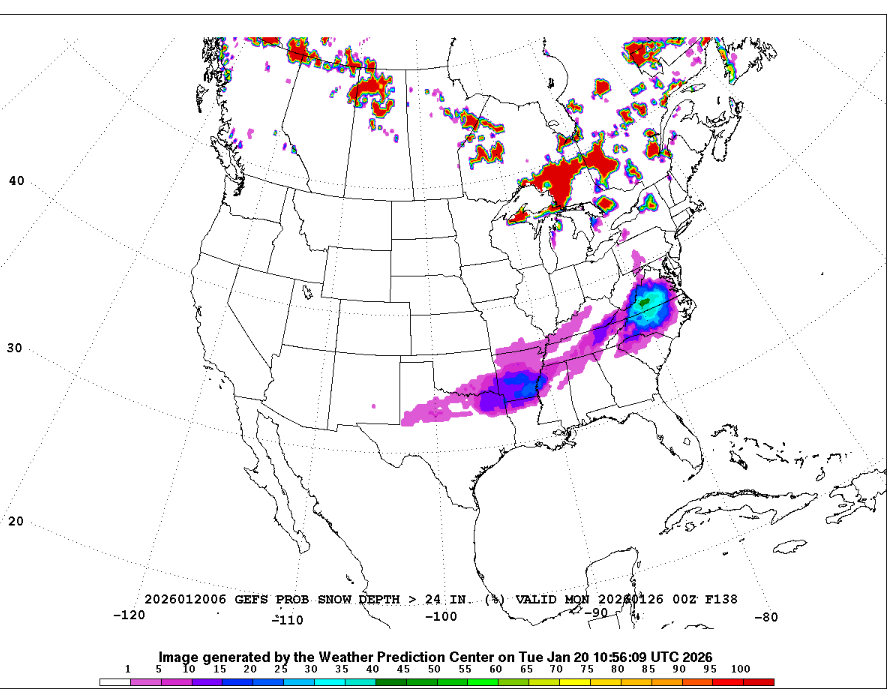
hot dawg, a non zero probability -
-
January 25/26 Jimbo Back Surgery Storm
WinstonSalemArlington replied to Jimbo!'s topic in Southeastern States
-
Yea definitely less than 4 days til go time now. Praying for no major jumps north..
-

January 25/26 Jimbo Back Surgery Storm
NorthHillsWx replied to Jimbo!'s topic in Southeastern States
@olafminesaw brings up a good point- this storm likely features the WAA “thump”. This is where heroes are made in the mix areas as that front end over performing or switching to mix too fast can make or break a storm. That is 100% something to watch for most areas. 2018 featured one of the heaviest front end thumps I can remember in Raleigh. We got 7-8” in like 6 hours before it switched to rain. In this case there will not be a switch to plain rain, but the thump might be just as important for storm total snowfall. -
As the flakes gently closed their eyes, they continued to dream. Thank you b w,….. As always …
-

E PA/NJ/DE Winter 2025-26 Obs/Discussion
Violentweatherfan replied to LVblizzard's topic in Philadelphia Region
I think it’s time for a thread, I’ll start it once I think of a nice title -
Poking around on my GSP forecast, kickoff time is actually around 10pm Friday. With that….we’re three days out now
-
Winter 2025-26 Medium/Long Range Discussion
A-L-E-K replied to michsnowfreak's topic in Lakes/Ohio Valley
-

Winter cancelled/uncancelled banter 25/26
Santa Claus replied to Rjay's topic in New York City Metro
it is not snowing next weekend -
Amen. Noticed this morning that finger of precip stretching into NC seems to find an earlier and earlier arrival time. GSP now has it starting around 10 pm Friday night in my neck of the woods. If so, it’s down to 3 days
-
Ephesians2 started following SnowenOutThere
-
I will add to pay attention to the NAM within 48 hours of the storm. It does amazingly well in CAD setups with warm noses. Its burned many of us before
-
also I have 8" on the year and you all have maybe half that, so the likely north trend = reversion to the mean
-

E PA/NJ/DE Winter 2025-26 Obs/Discussion
Violentweatherfan replied to LVblizzard's topic in Philadelphia Region
I-95 dry slotted in 2016 as well. Lost quite a bit of accumulation -

January 2026 regional war/obs/disco thread
WinterWolf replied to Baroclinic Zone's topic in New England
Somehow I bet you’ll manage to do alright if I had to guess. -

Possible Record Breaking Cold + Snow 1/25 - 1/26
North and West replied to TriPol's topic in New York City Metro
there's literally nothing worse in this forum than reading model play-by-play without maps from non-mets . . . -

January 25/26 Jimbo Back Surgery Storm
NorthHillsWx replied to Jimbo!'s topic in Southeastern States
^^^^^ THIS -
What do you think the cap is for this storm? Why is the Euro solution less snowy than solutions like the UK?
-

January 2026 regional war/obs/disco thread
weatherwiz replied to Baroclinic Zone's topic in New England
The biggest challenge in all of this is going to be how far south the Arctic boundary can get before stalling. This is always a big challenge...the past several winters dealing with these scenarios I think there has been a tendency for models to be not aggressive enough with how far into the South the boundary gets. Also, in this case it is very feasible the sfc front gets deeper into the South while say front around 850 is held back as it pushes against stronger mid-level ridging from the strong ridging east of Florida. This would play a big role in where cyclogenesis ultimately develops but looking at the pattern over the Northeast I think we would stand a good shot at building this north enough to at least get a significant event to the coast. -
January 24-25: Miracle or Mirage
SomeguyfromTakomaPark replied to stormtracker's topic in Mid Atlantic
Also if you use the beta version on the phone you have access to 6Z and 18z euros


