All Activity
- Past hour
-
lol
-
-
 70 here today.
 -

2025 Spring/Summer Mountain Thread
Met1985 replied to Maggie Valley Steve's topic in Southeastern States
Had a high today of only 76 with a current temp of 66. Very humid though. -
 Over wash at Jones Beach substantial, up to and underneath the boardwalk
 -
The rain is still falling lightly this evening. Though the W part of the county received ~3”+ necessitating a flash flood warning, my amount so far hasn’t added to that much…probably ~0.25” so far. That gets me to an amazing ~14.65” MTD with none of that from a TC! But that’s not the end of it!From KCHS NWS office, a flood watch has been issued for its entire area:SHORT TERM /FRIDAY THROUGH SUNDAY/FRIDAY AND SATURDAY: A COLD FRONT IS FORECAST TO STALL OVER THE AREA FRIDAY MORNING AND LINGER INTO SATURDAY. WAVES OF LOW PRESSURE SHOULD DEVELOP AND MOVE EAST ALONG THE FRONT AS SPOKES OF VORTICITY PASS THROUGH ALOFT. THIS COUPLED WITH BUILDING PWATS OF 2.25-2.50" AND WEAK TO MODERATE LEVELS OF INSTABILITY WILL SUPPORT NUMEROUS TO WIDESPREAD SHOWERS/TSTMS THROUGH THE PERIOD. THE STEERING FLOW WILL WEAKEN WITH TIME WITH MODIFIED SOUNDINGS SUGGESTING LONG/SKINNY CAPE PROFILES DEVELOPING FRIDAY AFTERNOON AND LINGERING INTO SATURDAY. THIS WILL SUPPORT CONVECTION WHERE WARM CLOUD PROCESSES WILL SUPPORT INTENSE RAINFALL RATES, POSSIBLY >3 IN/HR AT TIMES, GIVEN THE RICH, TROPICAL MOISTURE PLUME THAT WILL BE IN PLACE. THIS MAY LEAD TO AREAS OF FLASH FLOODING, ESPECIALLY IN THE CORRIDOR ROUGHLY SOUTH OF A REIDSVILLE-SPRINGFIELD-WALTERBORO-MONCKS CORNER LINE WHERE 20CM SOIL MOISTURE VALUES ARE RUNNING IN THE >98TH PERCENTILE AS OF THE 18 AUGUST ANALYSIS. GIVEN THE SATURATED SOIL MOISTURE PROFILES IN PLACE AND THE INTENSE HOURLY RAINFALL RATES THAT ARE POSSIBLE, THE RISK FOR FLASH FLOODING WILL BE ELEVATED INTO SATURDAY EVENING, ESPECIALLY IN THE COASTAL CORRIDOR WHERE THE EVENING HIGH TIDES BOTH FRIDAY AND SATURDAY COULD ENHANCED THE FLOOD THREAT. A FLOOD WATCH HAS BEEN ISSUED FROM FRIDAY MORNING THROUGH EARLY SUNDAY EVENING. STORM TOTALS DURING THIS PERIOD WILL RANGE FROM 2-4" WITH ISOLATED AMOUNTS POSSIBLY EXCEEDING 6".
-
 Flooding on Fire Island and the Hamptons, and water up to the dunes elsewhere. Jones Beach looks pretty rough. High tide looks to be coinciding with the worst of the waves. We’re lucky this turned out to sea.
 -
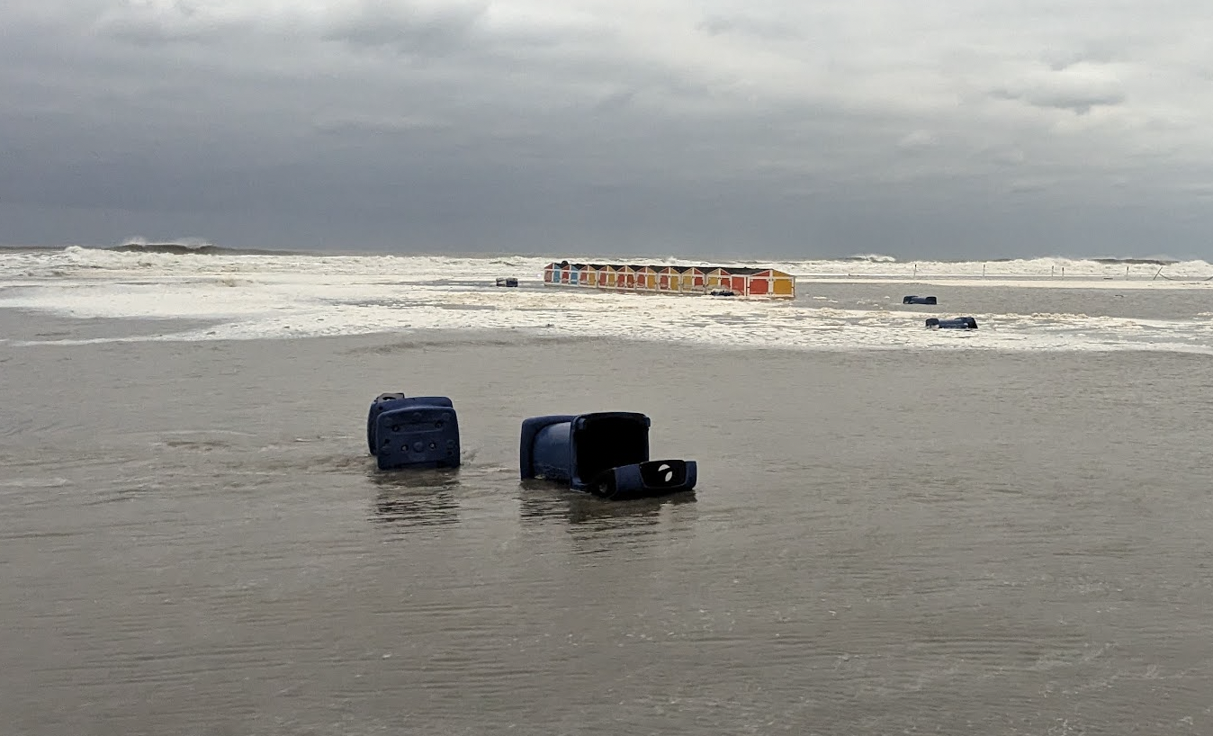
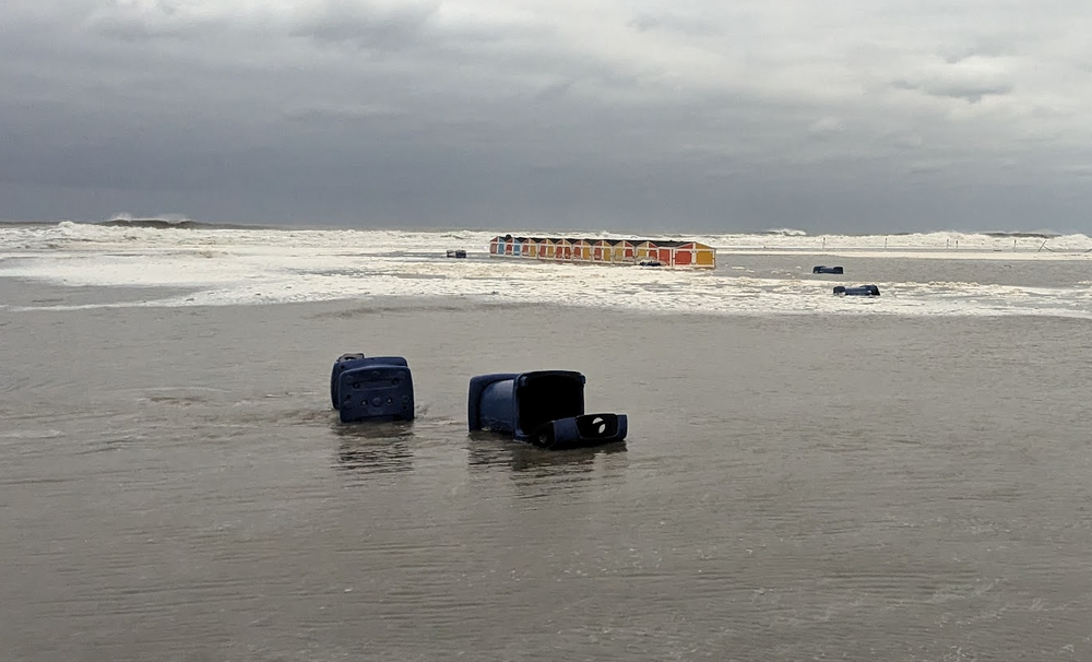
@frd Took two quick vids and I am not a videographer. High tide took the waves and water up to the dunes, which are usually 300-400 feet from the high tide line nearest our beach access here in Wildwood Crest. All the beach paraphernalia (rental equipment shacks, trash cans, porta potties, boardwalks to make the sand easier to cross) have been scattered about by the waves. Big cleanup job for the municipal crews coming up. https://streamable.com/7gouw7 https://streamable.com/yuiz6c
-
 There are some conflicting signals. Years with early extreme heat June-early July often have a bout of heat in September. However, years with the kind of cool shots as is occurring at present during August 20-31 typically have lower monthly maximum temperatures in September. August 20-31 had one or more lows in the 50s: Mean September maximum temperature: 86.9 All other years: Mean September maximum temperature: 89.9.
 -
T The face shot powder days to us in SNE
-
 Sorry, that was last year. Have to wait 2 months for that
 - Today
-

Hurricane Erin: 105 MPH - 945 mb - NNE @ 17
NorthHillsWx replied to BarryStantonGBP's topic in Tropical Headquarters
First time it’s come under our house since Isabel in 2003 -
DCA driest August on record watch.
-
I think plenty of things I don’t say. I’m not a bully so I just leave it. Not everyone has the same interests. I like storms and I also like greenness, so lack of rain bums me out. Having to water my plants constantly is also frustrating. I know most people don’t care and don’t have a drought where they live. Just don’t read what you aren’t interested in. If one person can commiserate it’s worth it to me and the rest can just skip past and enjoy themselves. What’s the point in stirring drama?
-
Point Judith today https://www.facebook.com/share/v/15nMk59uZv/
-
https://www.facebook.com/share/v/15nMk59uZv/ Point Judith today
-
 totally different out here-had it off since Monday morning. Wednesday was too cool to even have windows open
 - Yesterday
-
I don't think they're gonna let him get away with doing bare minimum to nothing IF they keep him one more year...unless he's somebody that doesn't care whether he loses his job or not, lol
-
It did get nice this evening. It's beautiful out right now. Late summer is definitely here.
-
 I'm not so sure. Usually when we've gotten these cool stretches in August, September reminds us it's still summer. CPC's also going above for our area in September. I think we probably do get a mini heatwave, maybe 1-2 days of 90 with a bunch of upper 80 days.
 -
Those Asian tiger bastards.
-
 summer is over Don
 -
No more 90 degrees, summer is over it's hard to have a hot day in September when it's been so cool in August (after that one heatwave I mean)
-
the AC is good to filter out bad air, I sometimes even turn it on during the winter as it helps keep my air clean. I haven't turned it on in the past 2 days but did turn on my space heater for a few hours each day. I have my fan on right now. If it's not hot (85 degrees or hotter), just turning on a fan will cool you down.