All Activity
- Past hour
-
I feel like GIF should have some techno music to it.
-
This isn’t good but not terrible either, especially for north of Knoxville .
-
“Cory’s in LA! Let’s MECS!” Jan. 24-26 Disco
Typhoon Tip replied to TheSnowman's topic in New England
Just to reiterate ... this is a low-grade cyclone and associated parametrics, but having a disproportionately larger ( much larger relative to climo on such cyclones - ) QPF potential due to maximizing PWAT anomalous air mass transported up and over cold/isentropic burst. I don't have a lot of personal faith in the idea of this thing having a lag back low pressure and active CCB - or if so...would that even be strong enough to be appreciably larger than what happens from the front loaded IB. As it looks now ( as in at this time) I'd go with .7 .. .9 if asked, and it's probably pretty evenly distributed ... or more so than the banding that happens from deeper cyclonic mechanics -
Its actually dangerous imo. Especially for the areas that are getting freezing rain out of this. Power outages at those temps is no joke.
-
2 pm briefing Heaviest Snow North of Knoxville Heaviest Ice in south portions of area 60% to 80% chance of at least 1 inch of meltwater Onset by 7 am on Saturday (medium confidence) Thinking it will start as snow then warm nose will show up Probability of 3 inches of snow Chattanooga - 10% Knoxville -55% Tri-Cities - 70% Over 8 inches Knoxville -15% Tri-Citis - 25% Probability of Freezing Rain >.25 Chattanooga - 60% Knoxville -25% Tri-cities - 15% Probability of Freezing Rain >.50 Chattanooga 20% .
-

“Cory’s in LA! Let’s MECS!” Jan. 24-26 Disco
The 4 Seasons replied to TheSnowman's topic in New England
-

January 25-26 Winter Storm Potential
The Iceman replied to Ralph Wiggum's topic in Philadelphia Region
Feb 2021 was like that too. Huge front end thump turning to sleet then ended as light snow. I know my total was over a foot, can't remember the exact amount at the moment. -
You'll need a generator also!
-
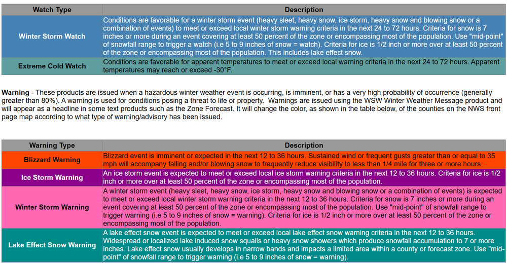
when did it go to 72? I think it use to be 36 then 48
-
One thing that (is expected with the more northern solutions) generally has decreased the likelyhood of 4+ inches over 24 hours from a near guarantee to a "mere" 80-90%
-
“Cory’s in LA! Let’s MECS!” Jan. 24-26 Disco
Chrisrotary12 replied to TheSnowman's topic in New England
In agreement with this but might remove the word hellacious from my current thinking. -
There’s gonna be a nasty CF in Essex county.
-
If we get even half the storm currently modeled with those post storm temps… DC area will be shutdown for days. Had a similar type setup a few years ago and secondary roads were skating rinks for nearly a week.
-
to be fair his observation about the mid level low tracking too far NW for what we typically want is not wrong. But there are more variables than just that. The depth of the cold in front makes this a situation where a further NW track than typically ideal might not hurt us as much. Remember February 2015 when a storm tracking into OHIO gave us 8-14" across our area before mixing with sleet/freezing rain, because there was arctic air in front...and there was absolutely no 50/50 or blocking with that setup...it was simple that a departing arctic high had left a shit ton (borrowing this from Randy) of cold air in place in front of it and the WAA needed to scour it out produced a ton of snow before we lost thermals. And that would be kind of a worst case scenario here given the setup is even better. So on the one hand I get what he is saying...he isn't wrong about that one thing being an "issue" but I think on the whole there are factors that offset that. Hopefully I don't get schooled by a legend here.
-
wrecked
-
Well, that's kind of extreme. I'd disagree with him in that Chicago is getting the goods while we mix/ice. Certainly won't rule out some sleet here, but I'd put the snow max along the spine of the Apps through central/northern MD.
-
He's been in informal communications with LWX. I think they are kind of all of on the same page that have been echoed here.
-
I think you meant 0Z Saturday
-

Central PA Winter 25/26 Discussion and Obs
paweather replied to MAG5035's topic in Upstate New York/Pennsylvania
12z EURO -
For a little historical reference, Jan 94 had a sleet bomb storm that cemented all week thanks to ridiculously cold temps after.
-
February 2021, and possibly GHD 2011...
-
Gotta ride with the GFS and the AIs for now. I wouldn't expect the track to adjust back southward in future runs. North trends at close range seem to occur more often.
-

“Cory’s in LA! Let’s MECS!” Jan. 24-26 Disco
The 4 Seasons replied to TheSnowman's topic in New England
72 hours. And in this case they are gonna use that because its higher than normal confidence. Based on where the watches have expanded east and probs have gone up to 80% categorical in OKX. Tomorrow night. Almost guarantee theyll be out by tomorrow pm package. -
Euro temps after this storm are hilarious. Lows in the negatives and wind chills down to -25


