All Activity
- Past hour
-

26th-27th event, coming at us like a wounded duck.
CoastalWx replied to Go Kart Mozart's topic in New England
He’s a former coworker who I taught how to forecast. -
25, Light snow. Everything dusted.
-
Started snowing not that long ago fast-forward everything is white roads haven’t been treated and it looks like a postcard outside still coming down kind of light but everything is sticking. Everything is white.
-

OBS/Totals for 12/26-27 Storm
SomeguyfromTakomaPark replied to jm1220's topic in New York City Metro
Getting close to SN+ in Yorktown, accumulating rapidly. -
Coating in upper east side but now in a lull before the main show gets going
-
Light-to-moderate snow in Larchmont. The ground is coated.
-

Winter 2025-26 Medium/Long Range Discussion
A-L-E-K replied to michsnowfreak's topic in Lakes/Ohio Valley
Duster watch 2026 -

Boxing Night Snow/Sleet/Ice Dec 26-27 Storm Thread/Obs.
Birds~69 replied to Mikeymac5306's topic in Philadelphia Region
Montgomery County Traffic Incidents Incident No. Incident Type Incident Sub Type Incident Location Municipality Dispatch Time P25772937 VEHICLE ACCIDENT EASTON RD & W COUNTY LINE RD HORSHAM 2025-12-26 17:03:57 P25772935 DISABLED VEHICLE MONTGOMERY AVE & AUCHY RD SPRINGFIELD 2025-12-26 17:01:37 P25772931 VEHICLE ACCIDENT LIMEKILN PIKE & S EASTON RD CHELTENHAM 2025-12-26 16:58:53 P25772928 DISABLED VEHICLE SKIPPACK PIKE & DEKALB PIKE WHITPAIN 2025-12-26 16:56:58 P25772919 VEHICLE ACCIDENT BETHEL RD & SKIPPACK PIKE WORCESTER 2025-12-26 16:52:52 P25772917 VEHICLE ACCIDENT SKIPPACK PIKE & SUNSET DR WHITPAIN 2025-12-26 16:51:33 P25772911 VEHICLE ACCIDENT SCHUYLKILL EXPY & RAMP MATSONFORD RD TO I76 EB LOWER MERION 2025-12-26 16:47:51 P25772909 VEHICLE ACCIDENT RED LION RD & PINE RD LOWER MORELAND 2025-12-26 16:46:19 P25772908 HAZARDOUS ROAD CONDITIONS MAIN ST & CLAMER AVE COLLEGEVILLE 2025-12-26 16:45:25 P25772886 VEHICLE ACCIDENT ASHMEAD RD & TOOKANY CREEK PKWY CHELTENHAM 2025-12-26 16:32:13 P25772863 VEHICLE ACCIDENT MORELAND RD & W MORELAND RD ABINGTON 2025-12-26 16:18:40 P25772861 VEHICLE ACCIDENT VALLEY FORGE RD & SUMNEYTOWN PIKE UPPER GWYNEDD 2025-12-26 16:17:50 P25772845 VEHICLE ACCIDENT -
Yes. We'll see if indeed that happens. That is why I mentioned to give it a couple of hours.
-

Wounded Duck Strikes Back: Dec 26 & 27th Winter Storm Obs
The 4 Seasons replied to WxWatcher007's topic in New England
Really missed an opportunity to call this Boxing Day II: The Wounded Duck Not a classic and historic nor'easter like Boxing Day but a large warning level event for a lot of SNE/Tri-State i think deserves the sequel name, especially if it over performs. OVC/25 -

Winter 2025-26 Medium/Long Range Discussion
IWXwx replied to michsnowfreak's topic in Lakes/Ohio Valley
Looks like an overperforming clipper to start the new year will be the best we can do for awhile. -

26th-27th event, coming at us like a wounded duck.
weatherwiz replied to Go Kart Mozart's topic in New England
This really got solidified quickly. This is a phenomenal sign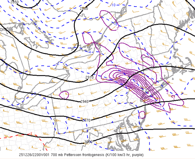
-

Central PA Winter 25/26 Discussion and Obs
Voyager replied to MAG5035's topic in Upstate New York/Pennsylvania
Two degree temp drop since my last post. Down to 23 now. -

Central PA Winter 25/26 Discussion and Obs
Summit Snow replied to MAG5035's topic in Upstate New York/Pennsylvania
Have over achieved so far this year and have a had a great start to winter so was do for an under. Precipitation came in as a wall of sleet and snow and is 80/20 sleet which wasn't even mentioned in the higher elevations this far NE until this AM and even then it was to be a gradual mix. Current temp is 18 with heavy sleet currently. -

26th-27th event, coming at us like a wounded duck.
Damage In Tolland replied to Go Kart Mozart's topic in New England
RAP is beast mode EOR -

December 2025 regional war/obs/disco thread
moneypitmike replied to Torch Tiger's topic in New England
While today's 19* high was downright warm compared to those in NH/VT, it is interesting how quickly one adapts to temperatures. You get all bundled up one day and the next you're taking the dog for a walk sans hat/gloves and it's no big deal. In any case. Sunday night/Monday is just a turd. The rain won't do too much to the snow. But rain is rain, and it sucks. No putting a shine on that sneaker. -
26th-27th event, coming at us like a wounded duck.
Damage In Tolland replied to Go Kart Mozart's topic in New England
Man Vortex loves to troll Scooter . Every post over the last year is a S Wey troll Scooter post. Things you love to see -
Same here at the moment. VERY LIGHT snow started about 10 minutes ago. More snow grains than anything.
-

26th-27th event, coming at us like a wounded duck.
ORH_wxman replied to Go Kart Mozart's topic in New England
Wondering if we can really rip on an ORH-PVD line now fora couple hours. That ML fronto has been holding together stronger on each run. -

Boxing Night Snow/Sleet/Ice Dec 26-27 Storm Thread/Obs.
Eskimo Joe replied to Mikeymac5306's topic in Philadelphia Region
Radar really lighting up over central and western PA. Looks like an icy night ahead for many. -

Central PA Winter 25/26 Discussion and Obs
Jns2183 replied to MAG5035's topic in Upstate New York/Pennsylvania
It's not new years but what the heck. I'm thankful for all who post here regardless of my agreement with them. This little forum provides me a vibrant joy year round. The disagreements provide a wonderful spice to life and I cherish them. I get to be a little weather nerd and I'm happy for that. Thank you all for participating in this little space. Sent from my SM-S731U using Tapatalk -
Light powdery snow here in Whitestone, immediately sticking to everything unlike last storm
-

Wounded Duck Strikes Back: Dec 26 & 27th Winter Storm Obs
WeatherX replied to WxWatcher007's topic in New England
Right to steady light snow on the edge of that heavy band. 20dbz on the radar. . -
24F/12 borderline moderate snow. Looking out my window 287 is going slow, tons of traffic on both sides.
-
I don't know why but I like the way Jan 2026 looks more than I did Jan 2025. Maybe it's because I'm thinking we'll have more precipitation to work with.


