All Activity
- Past hour
-
This week coming up definitely looks cooler here vs how it looked a week ago, but literally 200 miles SW of us may be tanning. It’s real close.
-
they've been heaving down here for a few weeks now. some side roads are brutal
-
Any OP solution that far out is for the glue factory. Ensembles do show some weak signal for a warm spell around that time, but ensembles this winter have been almost perpetually showing warm spells in clown range that haven't really verified....so we wait.
-
even if light i always prefer being in the blue
-
Pretty sweet day today. 37° and bright blue skies. Wish I was on the slopes.
-
He’s starting to get a little wild
-

Is we back? February discussion thread
RUNNAWAYICEBERG replied to mahk_webstah's topic in New England
Thankfully it’s on its way to the glue factory so we disregard until it gets put back together. -
Got to keep ACATT straight.
-
models playing with us like they did for a few runs after the 1/25 MECS
-
What’s your forecast?
-
Well looks like we just rescheduled for the 23rd as long as labs are still ok. Lol of course .
-

February 2026 OBS & Discussion
WeatherGeek2025 replied to Stormlover74's topic in New York City Metro
hopefully the bermuda High pressure trends stronger bouncing the low pressure gradient north of where it's modeled and bringing us even heavier precipitation than Euro ai showing -
Gotta go out further....it's in clown range but the OP tried to get us to 70F around 2/26 or so.
-

Is we back? February discussion thread
40/70 Benchmark replied to mahk_webstah's topic in New England
Who cares?? None of that necessarily means extreme cold -
The SLP strength and position on Sun night is highly sensitive to the strength/position of the minor shortwave in the northern stream flow. That's why the globals have been jumping around with the degree of phasing, notably and uncharacteristically the AIFS. It's also why a few individual ensemble members, especially a few days ago, showed big QPF numbers while the majority were light or complete misses. This setup is a little unusual for this winter in that we do have a strong southern stream wave traversing the country. It wouldn't take much northern stream interaction at all to get light to moderate precipitation up to at least CNJ. You gotta think the chances of precipitation in NYC are low, but it's the kind of setup that could change quickly in the short term.
-

February 2026 OBS & Discussion
donsutherland1 replied to Stormlover74's topic in New York City Metro
Today at the New York City Subforum: In reality, although the ECMWF-AIFS has brought back a moderate snowfall for Monday, the lack of ensemble support (at 0z), forecast temperatures, and its own unusual inconsistency over the past two days argues that its solution should be taken with a dose of skepticism. One should wait for additional support. For now, a light precipitation event remains possible. A moderate snowfall seems unlikely in the New York City area.
-
FYI mens half pipe is live and is sick. You can rewind on Peacock
-
Speedo? Yeah no
.thumb.png.2be6172032b1a8534ce83d595576f2cb.png)
-

Winter 2025-26 Medium/Long Range Discussion
A-L-E-K replied to michsnowfreak's topic in Lakes/Ohio Valley
problematic look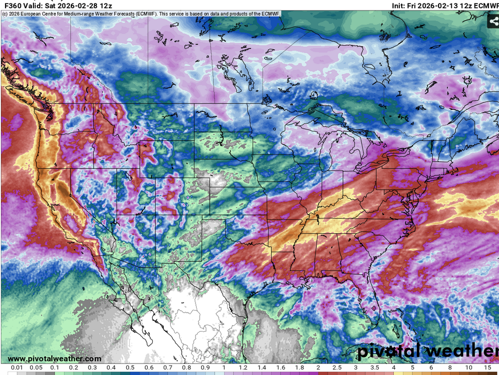
-
WPO is about to tank again. Expect the pattern to get colder again in the east.
-

E PA/NJ/DE Spring 2026 Obs/Discussion
RedSky replied to PhiEaglesfan712's topic in Philadelphia Region
32F feels warm after weeks of Alaska -
WPO is about to tank again. Expect the pattern to get colder again.
-
Frost heaves are starting to get noticeable now.
-
I don't know their names, but I'd bet my retirement it was one of these guys.

-
I have that shield thingy next to my name along with IrishRob and Forky. We’re the traitors like on the show. The Monday storm to me is still very low probability until I see other models jump onboard, it’s very fragile and we’ve seen all kinds of possible phasing setups fail over the last few winters so why would this be any different. We’re going to warm up for a while mid to late month but we have to see if the MJO can throw us a bone and allow for colder conditions to return at the end of the month. There can still be snow if we can time that with a storm.


.png.334eb30e8dcdbd7e61cf2785f4ae8a58.png)