All Activity
- Past hour
-

26th-27th event, coming at us like a wounded duck.
ariof replied to Go Kart Mozart's topic in New England
Me on I-84 pulling into Reins. -

Central PA Winter 25/26 Discussion and Obs
Jns2183 replied to MAG5035's topic in Upstate New York/Pennsylvania
Maybe the good forcasters were just on extended Christmas vacation and the a-team is all back in the office today. Sent from my SM-S731U using Tapatalk -

December 2025 regional war/obs/disco thread
VivaManchVegas replied to Torch Tiger's topic in New England
Long time lurker here. The moderators finally gave me my wings... thank you! I will chime in with some observations now and then. I am trying to think when the last white Christmas was here in S. NH. I think its been 10 years or so. Maybe someone can help with that. I don't count snow banks, 60 degrees and rolling fog to be a white Christmas. Cheers. Got down to 7 degrees here last night. -

26th-27th event, coming at us like a wounded duck.
Ginx snewx replied to Go Kart Mozart's topic in New England
Lol . Cobb Bufkit implies 8 plus for you. Ratios end up 12 to 1 -
1.1° with wind. Not fun for chickens.
-

26th-27th event, coming at us like a wounded duck.
CoastalWx replied to Go Kart Mozart's topic in New England
Stops at Vernon -
ok guys and gals let's do this ,,,,,,,6 pm Start time for first flakes or do you people think sooner ?
-
2F. Bummer on mondays rn but I've learned not to get too attached to the pack anymore Sent from my SM-S921U using Tapatalk
-

26th-27th event, coming at us like a wounded duck.
Damage In Tolland replied to Go Kart Mozart's topic in New England
Just couldn’t include TOL in there ? -

Central PA Winter 25/26 Discussion and Obs
pawatch replied to MAG5035's topic in Upstate New York/Pennsylvania
23 degrees this morning. Very red sky that lasted less than 5 minutes. All these forecasts are interesting. Obviously it’s easy to tell who the anti snow forecasters are. CTP still trying to save face from the earlier call. So many varied calls. -

26th-27th event, coming at us like a wounded duck.
weatherwiz replied to Go Kart Mozart's topic in New England
6z NAM bufkit for BDL. When I see -30 into the DGZ I get all tingly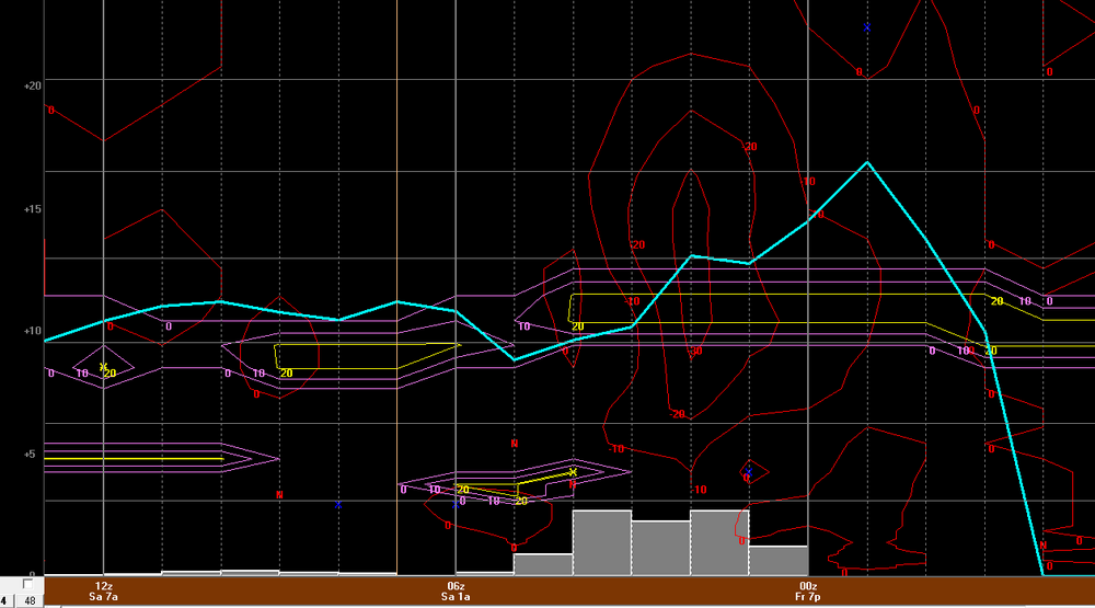
-

26th-27th event, coming at us like a wounded duck.
Baroclinic Zone replied to Go Kart Mozart's topic in New England
That will be fluff -
upton going 5-9 here-all will depend on banding...
-
26th-27th event, coming at us like a wounded duck.
Baroclinic Zone replied to Go Kart Mozart's topic in New England
Correct. I’m still pretty nooby about these things still so I’ll still defer to the more experienced folks to fill in. -
26th-27th event, coming at us like a wounded duck.
CoastalWx replied to Go Kart Mozart's topic in New England
Looks like maybe we CJ. Hope Emasswx hits that hard. -

26th-27th event, coming at us like a wounded duck.
ineedsnow replied to Go Kart Mozart's topic in New England
Early on but looks like the 12z HRRR won't disappoint -
17 degrees.
-
It may seem a bit quiet in here, and thus mean overnight runs were not good. Nope, they were good, especially regarding cold. The 6z GFS produced a run with the January 2 cold front, and the 6z Euro was headed that way. Does it get as cold as the 0z GEM which has been leading the way in finding cold fronts? Probably not - I hope not. But the GEM (let's see how 12z looks at lunch) may be on its way to scoring another coup. It identified the Dec 29-30th front first as well. That may mean we have a useful instrument going forward in identifying cold fronts - just add some degrees back. The 0z Euro looked really good at 500.
-

Central PA Winter 25/26 Discussion and Obs
Blizzard of 93 replied to MAG5035's topic in Upstate New York/Pennsylvania
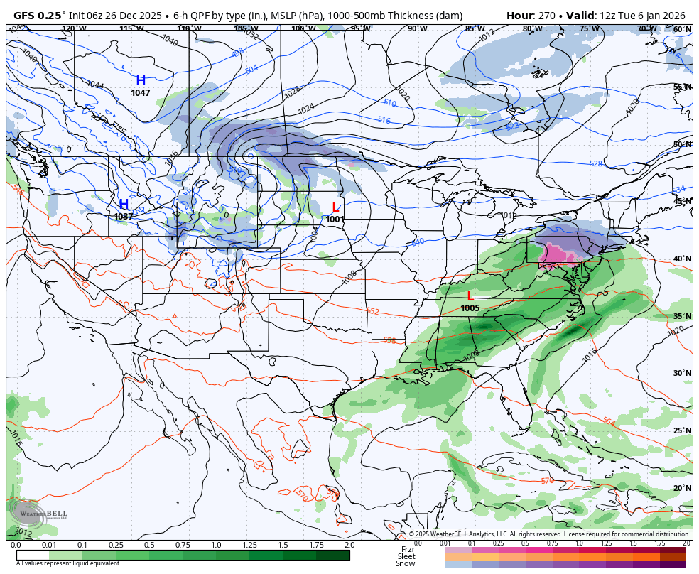
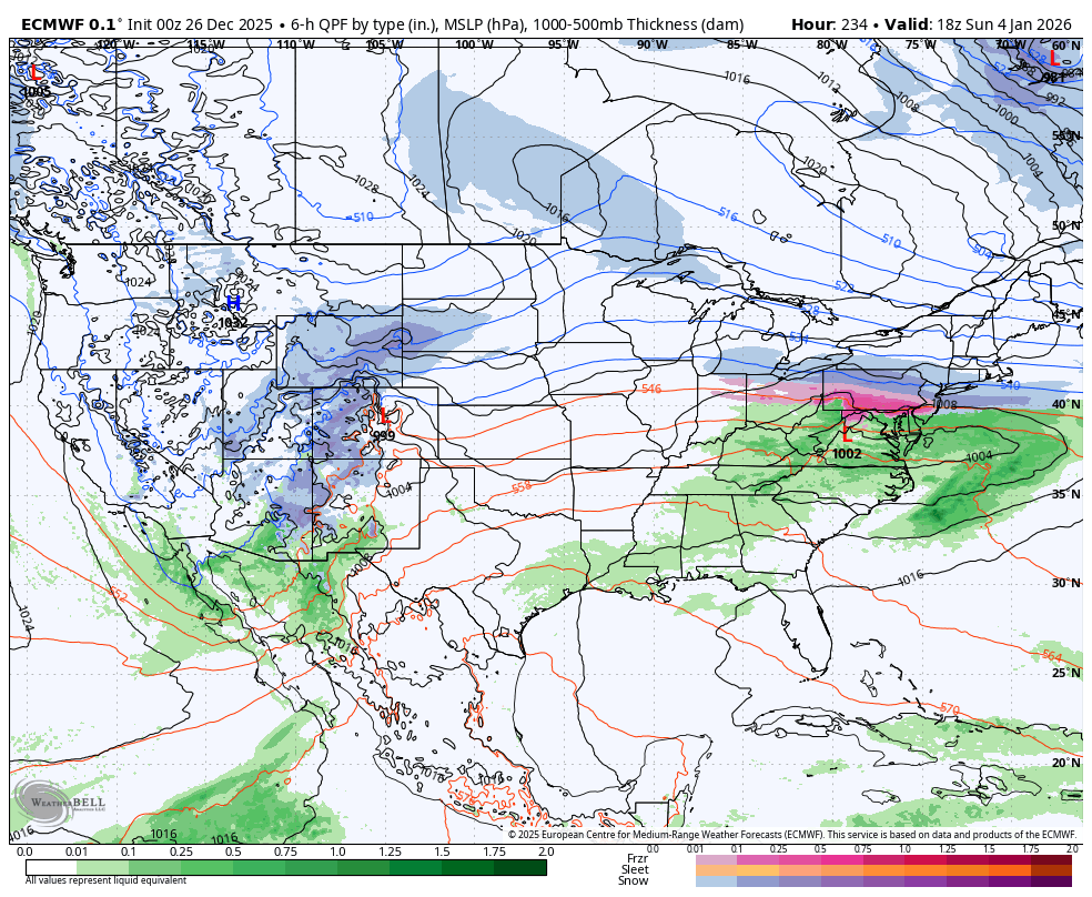
Looking out to the longer range, the full first week of January looks to be active with chances for Wintry weather. Current modeling shows storm systems actually approaching from the south & west instead of the current northern stream dominated pattern from the last few weeks. I think we may be busy tracking on here just after New Year’s. Here’s an example from the overnight Euro & GFS of the early January potential.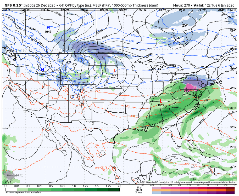

-
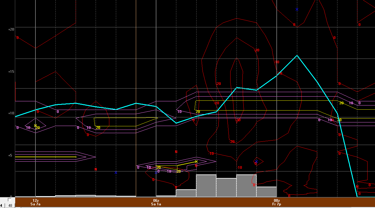
Look at the STLR for my neck of the woods! Snow to liquid ratios will be at or above the climo normals in the 13-17:1 range from south to north across the forecast area. The precipitation efficiency will be the best in the southern most zones based on the latest hi resolution and short range guidance, as the best dendritic growth zone will be higher across the northern zones. All said, a widespread moderate to locally heavy snow event is expected over the forecast area. .
-

26th-27th event, coming at us like a wounded duck.
ORH_wxman replied to Go Kart Mozart's topic in New England
There’s gonna be some strong bands in this because of how strong the fronto is….esp in western areas. It starts to weaken pretty fast once it crosses central areas but there’s still enough to produce decent snows. But further west it could pound at 2” per hour for a time. I think most of SNE will reach advisory snows…the question is how far northeast can the warning snows reach. I feel like right now it’s prob like a PSF-WST line…but inching that another 25 miles or so makes a big difference in affecting a lot more people (you start to include ORH and some of the towns east of there.) -

26th-27th event, coming at us like a wounded duck.
WinterWolf replied to Go Kart Mozart's topic in New England
Ok so maybe a dumb question here from somebody not quite as versed as others…but if the S/W energy is hanging back and consolidating the hast 12 hrs…wouldn’t that be a small sign that the system is not weakening/attenuating, but rather showing signs of the opposite? Or am I completely not understanding . -
They increased it for most if not all of the immediate metro areas
-

Central PA Winter 25/26 Discussion and Obs
mahantango#1 replied to MAG5035's topic in Upstate New York/Pennsylvania
Glad DT brings us back to reality. -
Central PA Winter 25/26 Discussion and Obs
Blizzard of 93 replied to MAG5035's topic in Upstate New York/Pennsylvania
More from CTP An impactful winter system is expected to impact central Pennsylvania on Boxing Day (Friday) with a wintry mix in play for the entire forecast area as a shortwave trough and low pressure associated with this feature currently stationed over the Midwest approach the region. Ahead of this system, departing high pressure has allowed for some clearing with a shallow cold air wedge beginning for form on the eastern periphery of the Appalachians, setting up a cold air damming (CAD) set up ahead of the precipitation. Given this signal, have trended temperatures throughout the entire near-term below NBM guidance given that there will be impact on precipitation types as temperatures generally range in the mid-to-upper 20s across the area as precipitation begins across the region. Recent model soundings continue to outline an elevated warm nose across western Pennsylvania, which continues to outline this area for the highest freezing rain potential with this system in the areas where an Ice Storm Warning remains in effect. The bulk of model guidance continues to outline freezing rain continuing throughout much of the event across the Laurels and portions of northwestern Pennsylvania, with the best timing for significant icing coming between 18Z-00Z (1pm-7pm EST) with some sleet beginning to mix in during this timeframe. Minimal changes to the forecast in this area of the CWA with this forecast cycle, thus the Ice Storm Warning remains in good shape moving forward. Further east, there recent HREF model guidance continues to outline the central third of the forecast area for sleet potential at onset with areas north/east of I-80/US-15 likely experiencing a brief window of snow before transitioning to sleet after 18Z (1pm EST). Sleet/snow accumulations generally range between below an inch for the southwestern two-thirds of the forecast area with recent NBM/HREF model guidance bringing a slight increase in snowfall totals across the eastern periphery of the forecast area, where 1-2" of storm-total snowfall is expected. Winter Weather Advisory remains unchanged this cycle; however, quicker movement of the system could promote the bulk of precipitation tapering off across the forecast area shortly after midnight Friday night.