All Activity
- Past hour
-

Central PA Fall Discussions and Obs
mahantango#1 replied to ChescoWx's topic in Upstate New York/Pennsylvania
But if temps were border line through the storm and also the sun was out to at time during this nor'easter. Just how much snow would have been left to measure over the course of 3 days? We can only hope for a better outcome for this upcoming winter. -
It’s possible the record low Arctic sea ice in the Kara and Barents is helping to strengthen the blocking there leading to most of our blocking episodes being more -AO dominant than -NAO dominant. Zack Labe @zacklabe.com · 1d In contrast to the other side of the #Arctic, sea ice along the Atlantic front is a record low for this time of year. This relates to the recent record warmth and southerly winds/waves pushing the marginal ice zone closer to the North Pole. Data from @nsidc.bsky.social (nsidc.org/data/seaice_...). ALT 39
-
Local station, KEEN, reports .34 inches total. I am about 20 miles away, and that seems right for here, too. We were under a giant hole in the precip most of yesterday. I am happy to see the big totals from parts of New England!
-

E PA/NJ/DE Autumn 2025 Obs/Discussion
BBasile replied to PhiEaglesfan712's topic in Philadelphia Region
Total is at 0.49". Still have an almost imperceivable mist falling. 53F -

The return of the elusive Nor'easter. Drought buster or bust?
nj2va replied to dailylurker's topic in Mid Atlantic
The constant drizzle storm -

Central PA Fall Discussions and Obs
pasnownut replied to ChescoWx's topic in Upstate New York/Pennsylvania
i also find it amusing that it was supposed to be another active year for hurricanes, and the "best" event that we got....was yesterdays "noreaster". -
Really hoped we would get sunshine and be rid of this miserable drizzle by the time I left the house. Storm doesn't want to leave.
-
It doesn't really add up IMO....they have slightly above average precip, normal temps...yet below average snow.
-

Spooky Season (October Disco Thread)
moneypitmike replied to Prismshine Productions's topic in New England
Nada up here in Maine from this event. Some good surf though. -
Central PA Fall Discussions and Obs
pasnownut replied to ChescoWx's topic in Upstate New York/Pennsylvania
yeah its no different than seeing epic snowmaps days prior and then being bummed that you only got 6". I'm with you....i'll take it anyday. -

Central PA Fall Discussions and Obs
Mount Joy Snowman replied to ChescoWx's topic in Upstate New York/Pennsylvania
Yeah we would have been around a foot with the northwest harrisburg folk about half that, sounds like a classic Nor'easter cutoff. Who knows, they may have made out better than us if the sleet line crept in from the southeast haha. -
 https://www.cbsnews.com/newyork/news/noreaster-coastal-flooding-long-island-high-tide/ As of 7:50 p.m., PSEG Long Island reported 2,052 customers were still without power. Orange & Rockland County reported just 204 customers were still out, after more than 4,000 were Monday morning. Jersey Central Power & Light had 1,523 customers out. PSE&G New Jersey had 250 out, down from over 2,300. New York City's Office of Emergency Management said more than 100 trees have fallen citywide, and the Department of Buildings said a woman in Brooklyn was killed when the wind ripped a solar panel off the roof of a carport. The storm also forced the cancellation of the city's annual Columbus Day Parade in Manhattan, a more than 80-year-old tradition.
 -
Not as bad here, but 4.04” since 8/1 isn’t great.
-
I was wondering if that's an artifact of the pattern changing in and of itself, or seasonal forced reconstruction - so to speak There's probably no difference there. So long as the pattern changes.. But the flow behavior in the modeling cinemas looks more charged, sped up with wave propagations that have real gradient. It's come on sort of sneaky over the last week, but now is much more coherent and raging going forward. Heh. It's almost like it's not so much a "dry to wet" pattern change, as it is a wholesale systemic change where getting more rain is intrinsic. Being that it is October and no longer July well...
-

E PA/NJ/DE Autumn 2025 Obs/Discussion
MGorse replied to PhiEaglesfan712's topic in Philadelphia Region
Picked up 0.07” since midnight. Going back to Saturday, my total is 0.32”. Still drizzling! -
That is nuts.
-
 Yeah we will get warmups ahead of each low.
 -
Spitting some drizzle. 0.23” total
-

Spooky Season (October Disco Thread)
dendrite replied to Prismshine Productions's topic in New England
No. We drought. -
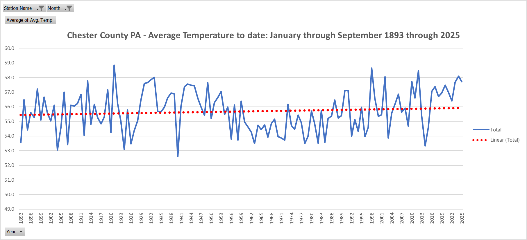
Below is the slow moving catastrophe here in Chester County....can you smell the fear in the air.....temperature? At this rate we might be burning up with an average temperature of 56.3 degrees in another 100 years!!
-
 Simply not true and not factual but ok
 -

Central PA Fall Discussions and Obs
Superstorm replied to ChescoWx's topic in Upstate New York/Pennsylvania
at 10:1 you would have 6" of snow. Ill take that anyday. -
no prolonged rains, just brief frontal passages, like one in about a week. Nice and sunny for several days starting tomorrow.
-
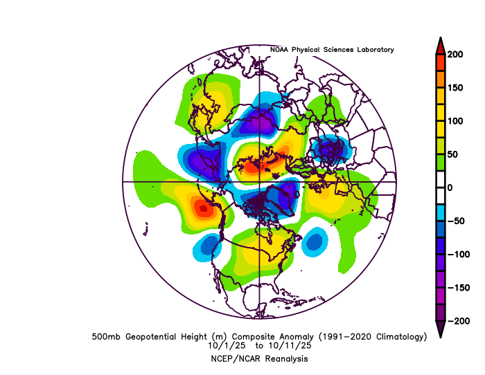
@Bluewave Thought you might find this interesting, it ties ocean current cycles in. Think arctic sea ice and solar also playing a role…


(002).thumb.png.6e3d9d46bca5fe41aab7a74871dd8af8.png)