All Activity
- Past hour
-

2025-2026 ENSO
brooklynwx99 replied to 40/70 Benchmark's topic in Weather Forecasting and Discussion
not to harp on last year, but models actually did a good job showing the amount of high latitude blocking that developed. to say that a good pattern never developed is just incorrect
-
The storm track pattern most of the time since 2018-2019 has been Great Lakes cutter, I-78 to I-84 hugger, and suppressed Southern Stream. This has been a result of the record WPAC warmth both in the subtropics and midlatitudes with a much faster Northern Stream of the Pacific Jet along the thermal gradient between the Siberian cold and WPAC to south of Aleutians warmth. Storm track #1 features a trough in the West and a Southeast ridge. So the low deepens crossing the Great Lakes with a warm storm track and mostly rain along the I-95 corridor from DC to Boston. Track# 2 features poor wavelength spacing in the fast Pacific flow so the storm hugs the I-78 to I-84 corridor favoring the interior regions away from the coast for the heaviest snows. Both these tracks feature too strong of a Southeast Ridge. Track #3 has a kicker low coming into Western North America in the fast Pacific flow keeping the Southern Stream suppressed and preventing a true 40/70 benchmark snowstorm track. Southeast ridge relaxes too much and the low slips to the Southeast. Even with a winter average temperature closer to the long term average last year, there was no deviation in this storm track pattern. Many times since February 2022 the long range forecast models have show big pattern changes during weeks 2 and 3. But we are yet to see a big change in this model bias. So this is why I like to temper long range expectations and wait until an actual pattern change shows up in the short term for it to be believable. RMM chart forecasts showing solid MJO 8 passages beyond 10 days out have either weakened before phase 8 due to the warm pool near the Maritime Continent or made it into 8 with lingering forcing hanging back near the Maritime Continent. So we didn’t get the true MJO 8 like we last had in January 2022. There have also been several events involving the stratosphere which haven’t panned out for snow or cold here. So this is why I don’t trust long range models to actually show pattern changes during weeks 2 and 3 since we have been through this numerous times before. But if we can actually get a shift in this pattern into the under 120 hr model forecast, then it will be something to be happy about.
-
2025-2026 ENSO
brooklynwx99 replied to 40/70 Benchmark's topic in Weather Forecasting and Discussion
explain to me how the pattern from last year never developed. i want receipts -

December 2025 Short/Medium Range Forecast Thread
Daniel Boone replied to John1122's topic in Tennessee Valley
Bastardi with a list of similar MJO Rotation Year's. Interesting. https://x.com/BigJoeBastardi/status/1991636264131375456?t=RlTjHjywEdZ-E3BZU65rwA&s=19 -

November 2025 general discussions and probable topic derailings ...
WinterWolf replied to Typhoon Tip's topic in New England
Ya, it can be understood a couple different ways. I was thinking if 17F is the highest, and -4F was the coldest, the difference between the two is 21 degrees, and that would be the “Range” is what I was thinking. But again, maybe I misunderstood? -
Nah...very, very predictable. To be followed up with a "like" emoji by Snowman.
-

2025-2026 ENSO
PhiEaglesfan712 replied to 40/70 Benchmark's topic in Weather Forecasting and Discussion
I'd be okay with something like December 2017, when the warm-up was very brief, and the majority of the 2nd half of December is cold. This is certainly possible. I mean, we're overdue for one. -
Down to 31. Frosty outside on the deck.
-
You always post the same day 15+ ensembles that show a supposedly amazing pattern that never comes to fruition
- Yesterday
-
Bet the over on that 25 years for some of us…
-

November 2025 general discussions and probable topic derailings ...
dendrite replied to Typhoon Tip's topic in New England
18z gfs would push the 62° on Thanksgiving too if they could pop some sun in that warm sector. -

Central PA Fall Discussions and Obs
Voyager replied to ChescoWx's topic in Upstate New York/Pennsylvania
I haven't seen many lightning videos, but the rain and hail videos were something else. -
We have had numerous model forecast attempts beyond 10 days to try and shift the storm tracks pattern since February 2022. But none have made to under 120 hrs on the models It’s still possible that something could eventually shift. But it won’t be believable until it shows up under 120 hrs.
-

November 2025 general discussions and probable topic derailings ...
ORH_wxman replied to Typhoon Tip's topic in New England
BOS will prob get colder post-Tday on that weekend. Into the 20s I’d think. -

Central PA Fall Discussions and Obs
Jns2183 replied to ChescoWx's topic in Upstate New York/Pennsylvania
Also I'm on my nightly 5 mile jaunt while the kiddo is swimming and it's misting out. Winds are calm but I'm figuring there has to be some low level moisture being pumped in from the coast Sent from my SM-G970U1 using Tapatalk -
Unless it’s playing the B1G. Hopefully we see a big midwestern OL steamroll that ridge in a couple of weeks.
-

November 2025 general discussions and probable topic derailings ...
powderfreak replied to Typhoon Tip's topic in New England
I read it as the November lowest temperature has ranged from 17F (in two years) to -4F as the coldest. -
Central PA Fall Discussions and Obs
Jns2183 replied to ChescoWx's topic in Upstate New York/Pennsylvania
Are you staying Friday or Saturday night there? I can see us back here with a few fluffy inches watching as some death band spitting out giant half inch dendies so hard you can't even hear the PA system Sent from my SM-G970U1 using Tapatalk -
Central PA Fall Discussions and Obs
Jns2183 replied to ChescoWx's topic in Upstate New York/Pennsylvania
That map blizz had with the snow ripping up that way was for 18z Saturday Sent from my SM-G970U1 using Tapatalk -

Central PA Fall Discussions and Obs
Mount Joy Snowman replied to ChescoWx's topic in Upstate New York/Pennsylvania
Oh heck yeah, sign me up. If you could guarantee the storm holds off for travel but then dumps for the game, would be incredible. -
It will turn milder tomorrow. Once in place, the generally milder than normal pattern will likely continue into the closing days of November. However, exceptional warmth appears unlikely. The closing days of November could turn cooler. Meanwhile, today will be Central Park's 1,391st consecutive day without daily snowfall of 4" or more. The record of 1,394 days was set during February 22, 1929 through December 16, 1932. That stretch ended with 6.7" daily snowfall on December 17, 1932. The ENSO Region 1+2 anomaly was -0.7°C and the Region 3.4 anomaly was -0.7°C for the week centered around November 12. For the past six weeks, the ENSO Region 1+2 anomaly has averaged -0.16°C and the ENSO Region 3.4 anomaly has averaged -0.65°C. La Niña conditions will likely continue through at least mid-winter. The SOI was +31.43 today. The preliminary Arctic Oscillation (AO) was -0.316 today. Based on sensitivity analysis applied to the latest guidance, there is an implied 78% probability that New York City will have a cooler than normal November (1991-2020 normal). November will likely finish with a mean temperature near 46.9° (1.1° below normal). Supplemental Information: The projected mean would be 0.8° below the 1981-2010 normal monthly value.
-
Some of you on here are so delusional its sad.
-

MO/KS/AR/OK 2025-2026 Winter Discussion
NWAflizzard replied to stormdragonwx's topic in Central/Western States
Cold air stalls out west on the 18z GFS and doesn’t make its way east. Huge difference in temperature across Kansas.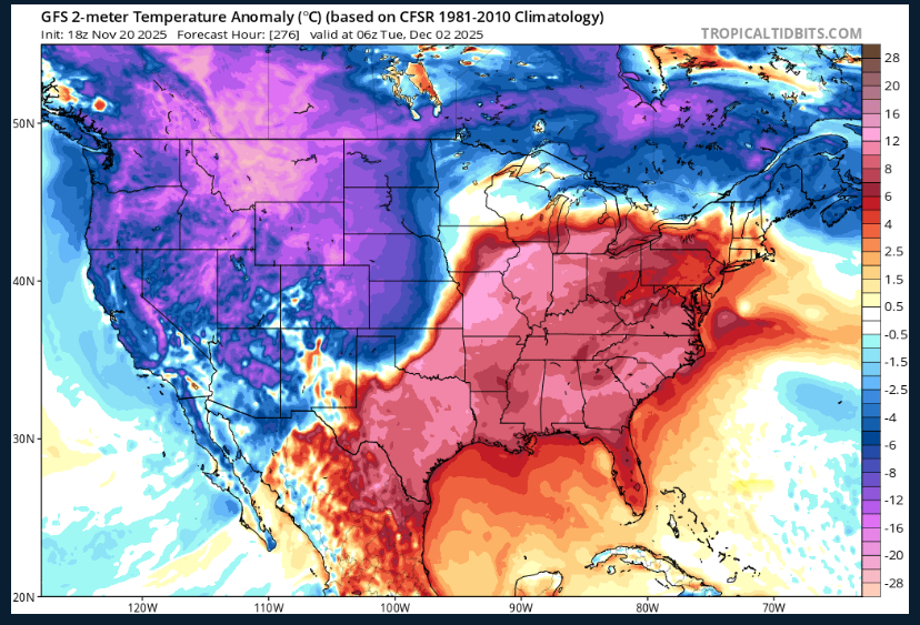
-
Yep, on the 18th NWS called for a 55 high here. Stuck in the upper 30's all day, high was 41.5 at midnight and then locked between 40-41 overnight until 7 am.