All Activity
- Past hour
-
Widespread 90mph near ALB. lol
-
DVN just issued the lamest winter storm warning in history. Talk about setting the bar low. Brief snow squalls with most areas seeing a DAB. Might as well just go all in and go with a blizzard warning, or hurricane warning.
-
Not sure why. I haven’t explored it deeply enough to find the reason. Maybe papers have been written on this already, but most are focused on El Ninos rather than La Ninas.
-
Doubt anyone anywhere sees much of any NAO blocking, unless an actual Scandinavian block happens first. The open ridges rolling over won't work for anyone. Including Europe. Models and ensembles still all over the place with that too. And that's something starting towards day 7 at this point. Need it to happen...
-
Clowns gonna clown
-

December 2025 regional war/obs/disco thread
weatherwiz replied to Torch Tiger's topic in New England
what in the sam hell. What boundary layer physics/equations are used by the HRDPS? That looks like its mixing down 100% of 925mb lmao. Does it think 10m is 925mb -
Looks like nasty squall line moving through during the morning rush tomorrow? Could be miserable. .
-

December 2025 regional war/obs/disco thread
Damage In Tolland replied to Torch Tiger's topic in New England
You let him sway your ideas and forecasts way too much . -

December 2025 Short/Medium Range Forecast Thread
Golf757075 replied to John1122's topic in Tennessee Valley
Then feb 1-2 1996 was a heck of a winter storm in my area. Very cold after that -

Central PA Winter 25/26 Discussion and Obs
canderson replied to MAG5035's topic in Upstate New York/Pennsylvania
My guess for peak gust at MDT tomorrow late afternoon: 57 mph -

December 2025 Short/Medium Range Forecast Thread
Holston_River_Rambler replied to John1122's topic in Tennessee Valley
I was trying to pull the radar imagery from IEM as gif, but the file won't process. Here's a link if anyone wants to check it out: https://mesonet.agron.iastate.edu/current/mcview.phtml?prod=usrad&java=script&mode=archive&frames=400&interval=60&year=1996&month=12&day=25&hour=0&minute=0 I think most folks who were alive at that time in upper east TN and SW VA know where the pattern ends up about Jan 7 - 8, 1996. -
Will this age like wine or milk? https://x.com/capitalweather/status/2001702501557374997?s=46
-
We had blowing fog here this morning. Don't think I've ever seen that before. There were waves of dense fog whipping horizontally with the gusty south winds over the remaining snow cover. Thought it was blowing snow at first until I realized what it was. All the snow is gone here now, other than piles. Rain mixed with wet snow right at the end. Picked up 0.19" of rain.
-
I thought that there was measurable precipitation on 12/31/23? If not, it's six out of the 7 years.
-
18z Euro still pretty nice for 12/23. Widespread 1-3”.
-
I see that everyone is in a Holly Jolly mood a week before Christmas. .
-
It's insane what people can accomplish with paint. I am decent with a pen but you just can't recreate sunlight contrast quite as well as with oil, and it's nearly impossible to make a scene seem genuinely life-like without properly representing even the smallest patches of sun. These are astounding, the way they capture natural lighting even better than a camera can.
-
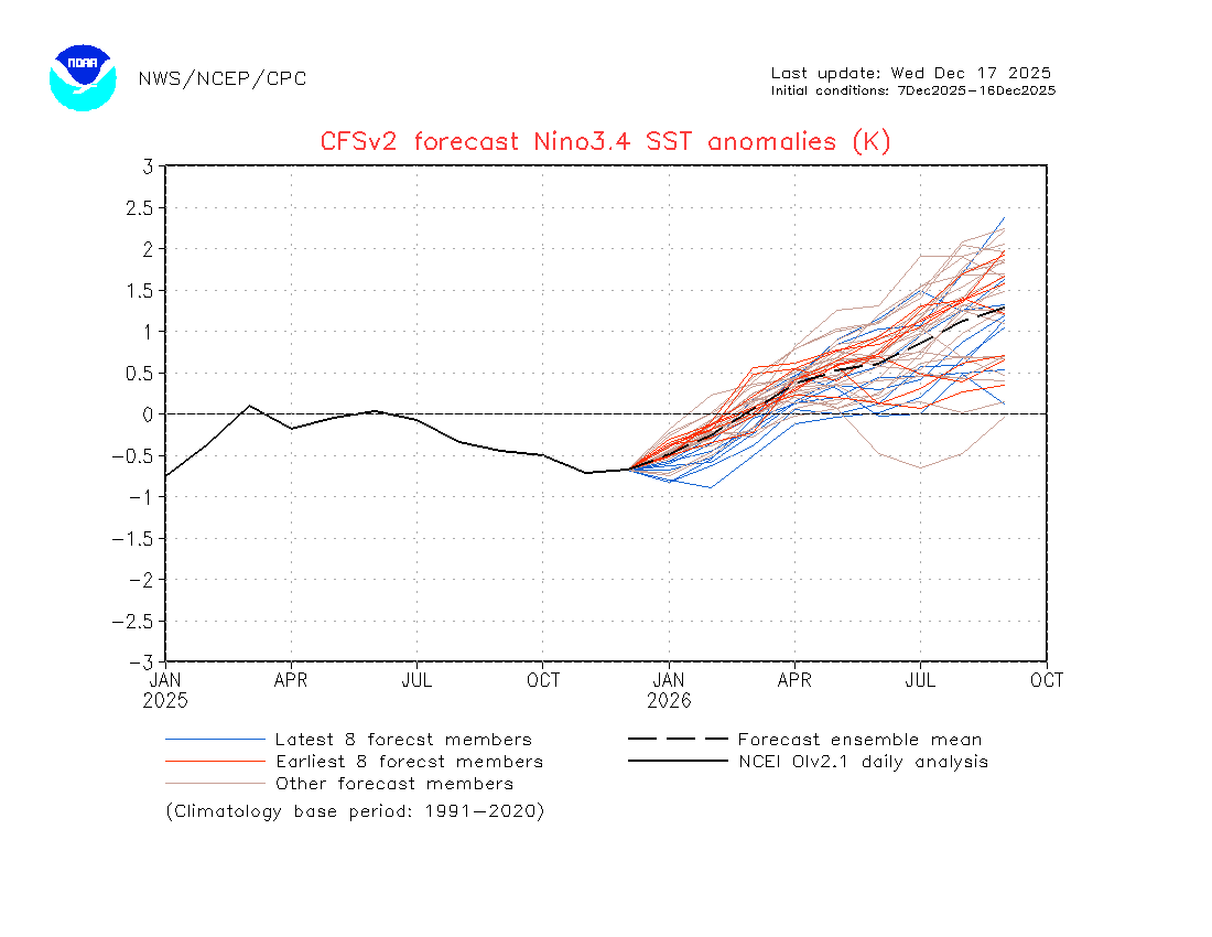
You mentioned that previously, but the Cfs has it getting stronger in its last few forecasts. Here's the latest. When I say strongest, I mean more members are calling for a temp drop.

-
-
Why is this the case?
-
A soaking rain will develop tonight with a storm total 0.50"-1.50" rain likely across the region by the time the storm pulls away late tomorrow. The wind could also gust past 50 mph producing some coastal flooding and beach erosion. It will also be unseasonably mild tomorrow with highs reaching the lower and middle 50s. Behind the storm, the weekend will turn somewhat cooler. No exceptionally cold or warm weather appears likely for the first week of astronomical winter. The probability that December 2025 will have a maximum monthly temperature below 60° has continued to increase. The last time that happened was in 2019 when the monthly high was 58°. If 2025 has a monthly high below 60°, that would be only the fifth such occurrence since 2000 (2003, 2004, 2005, and 2019 are the cases since 2000). The ENSO Region 1+2 anomaly was -0.3°C and the Region 3.4 anomaly was -0.7°C for the week centered around December 10. For the past six weeks, the ENSO Region 1+2 anomaly has averaged -0.33°C and the ENSO Region 3.4 anomaly has averaged -0.67°C. La Niña conditions will likely continue through at least mid-winter. The SOI was -2.23 today. The preliminary Arctic Oscillation (AO) was +2.676 today. Based on sensitivity analysis applied to the latest guidance, there is an implied near 99% probability that New York City will have a cooler than normal December (1991-2020 normal). December will likely finish with a mean temperature near 33.9° (5.2° below normal). Supplemental Information: The projected mean would be 3.5° below the 1981-2010 normal monthly value.
-
December 2025 Short/Medium Range Forecast Thread
Holston_River_Rambler replied to John1122's topic in Tennessee Valley
That definitely looks better, but as far as I can tell, there's nary and Aleutian ridge o' death to be seen I had to go back to early December 1995 to see something similar: -
Too much beer in yours.
-

December 2025 Short/Medium Range Forecast Thread
Daniel Boone replied to John1122's topic in Tennessee Valley
Nina HP was well south then . By Christmas a +PNA with the HP centered over the NW and LP over Aleutians. Trough in East. We should further that Winter in increments in Time and see what evolution was. -

E PA/NJ/DE Winter 2025-26 Obs/Discussion
Birds~69 replied to LVblizzard's topic in Philadelphia Region
Big fan of cool/cold rain and wind. I point and giggle when neighbors stuff gets blown all around, they usually don't like my reaction/response. Drought guy will probably make a appearance as well....happy times. 43F/Overcast