All Activity
- Past hour
-
It is honestly obscene. Was in a mall parking lot last night and i t was LOADED with rock salt. Almost could not see pavement though it.
-
.thumb.png.4150b06c63a21f61052e47a612bf1818.png)
December 2025 regional war/obs/disco thread
HIPPYVALLEY replied to Torch Tiger's topic in New England
I thought T-Blizz was joking about that. It’s bright blue skies in Greenfield right now. -

December 2025 Short/Medium Range Forecast Thread
Carvers Gap replied to John1122's topic in Tennessee Valley
Since 1980, the only month I can find w/ a faster(low max temp) start is 1985. Here is the Dec 1-4 data for 2025. These are the max temp departures. As Boone noted, overnight departures are not as strong. I have to think that is due to a lot of fog and cloud cover. I'll update w/ more recent numbers when this updates again. -
One benefit to living in one of the worst snowfall areas in the region is that I was able to test my new bike (Trek FX2). Needed something different for pavement. Chilly out, but not that cold.
-
Let’s do it
-
I don't understand why this is the new trend. We got 1 inch of snow on Tuesday and the roads look like the middle of February after a blizzard.
-
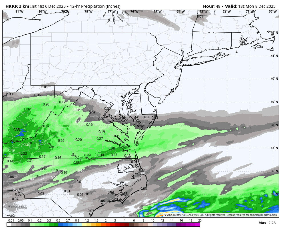
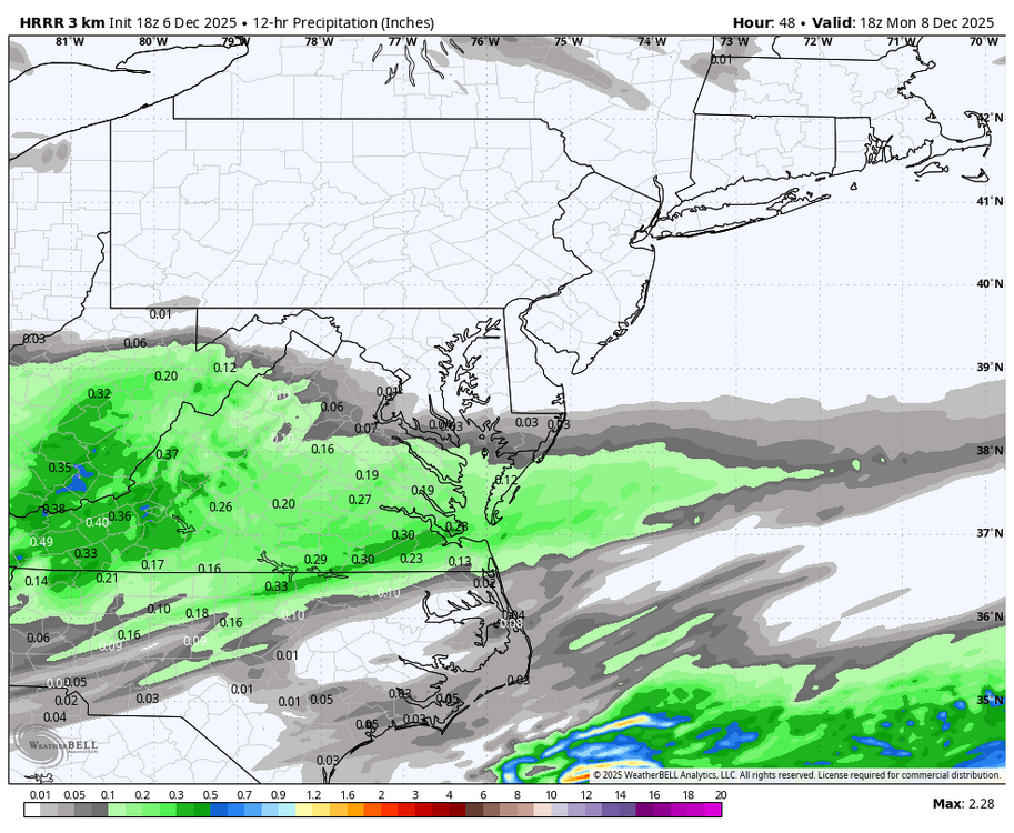
Long Range HRRR for Monday
-

December 2025 regional war/obs/disco thread
moneypitmike replied to Torch Tiger's topic in New England
Those winds will put the 4x more I needed to pay for property insurance at the new Pit to the test. -
We are so close, it’s easy to see. Right now, we’re getting the red track with these shortwaves, which continues to favor a lack of digging and marginal weak events into the mid-Atlantic. Nudge that trough west so it’s centered over the lakes and we’ll be ready for takeoff. It wouldn’t take much to trend that direction - it’s really a small tweak at range. Pumping that ridge out west would be helpful too but we can’t have everything. .
-
December 2025 Short/Medium Range Forecast Thread
Carvers Gap replied to John1122's topic in Tennessee Valley
With the potential or much colder temps this month, and a tendency not to soar way AN....we could be looking at a top 10 cold month for TRI. I'll have to go check and see...but that is off the top of my head. 7 day ensembles for mid month are -10 to 15F BN -
Yes, this is very reminiscent of the winter weather pattern we had last January and last February, which mainly has suppressed storms that targeted the southern US and areas of the lower Midwest, while most of the rest of the country was cold and dry. With this next push of arctic air there simply isn’t enough of a southern stream to coincide with the arctic air and produce much meaningful snow. Instead, we are stuck with the winter pattern from last year, which is dry, cold, and any snow is usually suppressed.
-
 As I live and breathe, I did not buy into this post. Woke up to about 0.1" of the white stuff.
 -

2025-2026 Fall/Winter Mountain Thread
CentralNC replied to Buckethead's topic in Southeastern States
It is very early, but has a "wasting cold air" type feel to this pattern. -
The sky looks like snow in Raleigh today but of course nothing is falling.
-

December 2025 Short/Medium Range Forecast Thread
John1122 replied to John1122's topic in Tennessee Valley
We are -8 for the month, but normally you arrive there by being -16 and then normal over short periods. This has been essentially-7 to -10 each day, so nothing super cold. -
December 2025 Short/Medium Range Forecast Thread
Carvers Gap replied to John1122's topic in Tennessee Valley
I am just now catching up on overnight and afternoon modeling, so please forgive me if I am on stepping in old footprints. These are the real feel temps for the mid-month cold front. The GFS I "think" had this on d16 of its run a few days ago. It is now well within d10. The 12z EPS is the colder of all the ensembles, and that gets my attention w/ its usual warm bias. Some deterministic models don't get us above 20 degrees. This reminds me of the 09-10 setup. It got cold right as school let out - as in the very day school was dismissed for Christmas. Cars were stranded in a pretty good commuter snow storm. This could be an 83-84 deal where it gets cold and doesn't snow. I fully see that. However, I see the Euro cranking a big storm high around this time frame. Often, we will see cold temps and big snows coupled. These temps are pretty much on bare ground. The GFS gets TRI below zero(in some places) with actual temps. The thing that concerns me a bit is that the GFS has the warmest MJO!!! If it is just now catching on(and it has a habit of seeing cold shots before other models at range during December), then look out. Still time for things to change, but a big shot of cold air is growing likely but not certain. Once we get to day 6-7, I think the cold is baked in the cake...so a few more runs to go. TRI has managed -6.8F and TYS -7F(for the first six days of the month) without strong amplification. What I am seeing w/ deterministic runs is a tendency to amplify the pattern sooner than later. -

Dec 6-7th (It's not a clipper) Clipper
frostfern replied to Chicago Storm's topic in Lakes/Ohio Valley
Summer is invading winter. What happened to lake effect? -
December 2025 Short/Medium Range Forecast Thread
John1122 replied to John1122's topic in Tennessee Valley
To me, it's the shape of the ridge in the West. It's not been sharp S to N oriented so the cold hasn't been pressing south, more West to East. The GFS sharpens the Western Ridge and the cold crashes south. -
Pattern just has the feel that is something is going to pop, and without much particular warning.
-
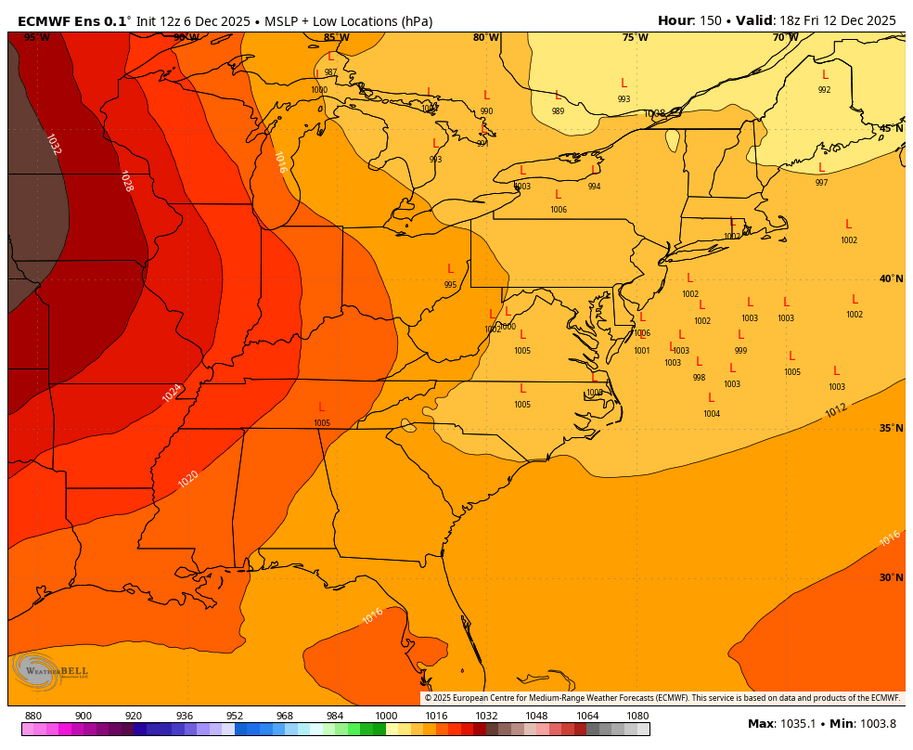
There’s a decent signal on the 12z EPS for a chance of another Advisory type of event in the Friday/Saturday period.
-
Cold and dry seems about right.
-
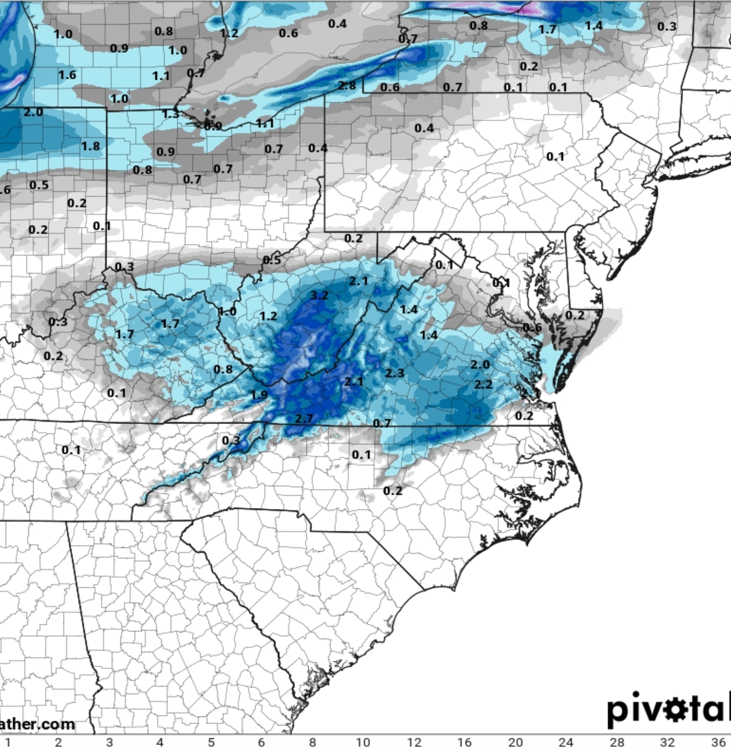
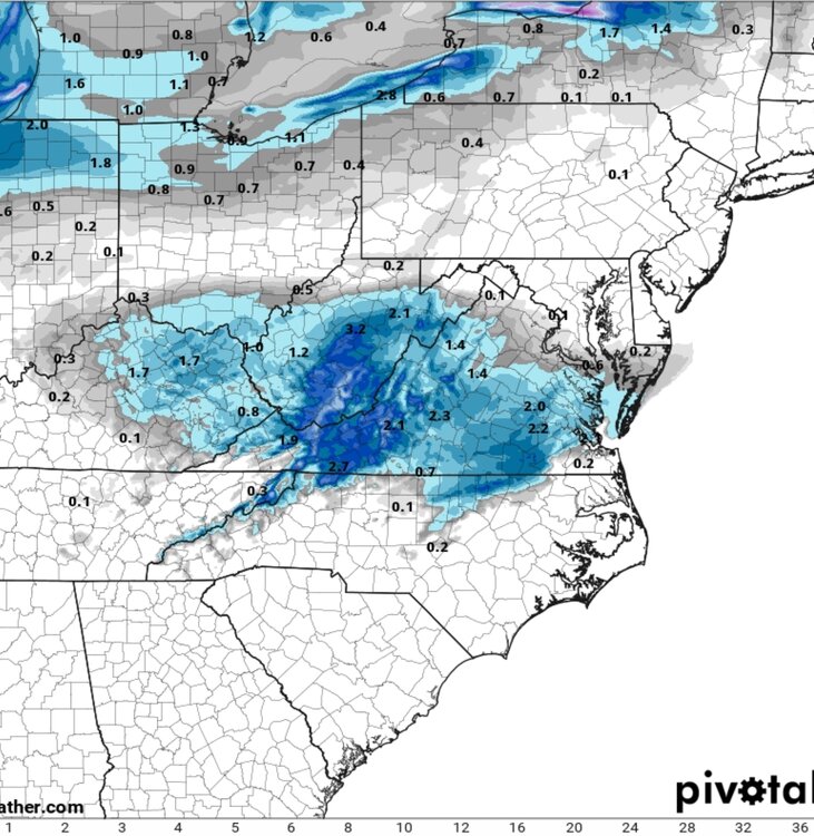
Long range HRRR is intriguing too. If I was you I’d be thinking about a 0.5” refresher course down there. See if we can get any more juice or a northern push in the next 36 hours. Ease off the confluence a little bit more…
-

Central PA Fall Discussions and Obs
Blizzard of 93 replied to ChescoWx's topic in Upstate New York/Pennsylvania
There’s a decent signal on the 12z EPS for a chance of another Advisory type of event in the Friday/Saturday period.
-
December 2025 Short/Medium Range Forecast Thread
Carvers Gap replied to John1122's topic in Tennessee Valley
The other thing I am noticing is an uptick of the mean snow total over TRI. That might be "IMBY" a bit too much, but that is usually a good thing for everyone when it goes up. The 12z AIFS-Ensemble has 2-5" of snow from TYS to SW VA. The 12z GEFS has 1-6" of snow from TYS to TRI. -
12/5: 1.5”