All Activity
- Past hour
-

Central PA Summer 2026 Discussion/Obs Thread
mahantango#1 replied to Voyager's topic in Upstate New York/Pennsylvania
-
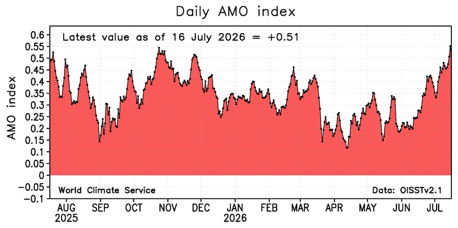
Impressive severe and flash flooding threat. The AMO has rapidly increased to near record levels. So a deep tropical moisture feed with strong shear.
-
Central PA Summer 2026 Discussion/Obs Thread
mahantango#1 replied to Voyager's topic in Upstate New York/Pennsylvania
.DISCUSSION... -- Changed Discussion -- KEY MESSAGE 1: Severe thunderstorms with damaging winds and heavy rainfall are possible from mid-day into late evening. Tornadoes also possible. SPC has kept the Enhanced risk of severe weather expectation for all of Central PA today. They have also added a special (conditional intensity group or CIG) hatching to SErn PA (including areas S & E of Harrisburg. The CIG designation means that tornadoes that do develop in that area could be stronger than just EF0/1. A reasonable maximum intensity of EF2-strength tornadoes is possible today - again, mainly in SE PA. Early showers and even a thunderstorm or two will occur near/along a pair of warm fronts moving north and east through the area this morning and early afternoon. The vort max moving into western PA at 07Z is expected to continue to touch off showers this morning. Some lightning is possible, mainly across the S. There should not be a threat for severe weather until at least late this morning after we can get the clouds and showers away and get some heating/pump up the CAPE. The timing of that vort max and the SHRA/TSRA it helps generate look like they will be early enough in the day that ample heating should then occur as the main warm front pushes into the srn counties and across the CWA late this morning and early this afternoon. As the CAPEs climb, and the wind profiles/hodographs become rounded, the risk for deep convection that would also take advantage of the high helicity to produce supercells increases. This convection could start a couple hours earlier than climatologically-favored timing...more like a noon kickoff than early- to mid-aftn. The risk for discrete, spinning cells is highest over the Lower Susq, but is possible anywhere across the CWA with the warm front(s) and varied boundaries from earlier rain and differential heating playing roles to make the near storm llvl/blyr environment favorable. 70F+ dewpoints will arrive in the S with the first warm front, and the LCLs should be low and favorable for tornado development. The Sig Tor Parameter (STP) is highest over the SE, esp in Lancaster Co. Lower (l-m60s) dewpoints hang on across the N for much of the day. The NW will have the next-best chance for severe storms to develop. However, the increasing moisture and moderate-high shear and moderate-high CAPEs will mean we`ll have to watch all of the CWA for storm initiation in early and mid afternoon. These could also be supercells away from the SE - at least early in the event. The wind profile becomes more-aligned/straight hodographs that would be more favorable for storm clusters or a broken line, esp if a pre-frontal trough materializes. -
Must have been the profile pic change. Thanks @EastCoast NPZ
-
Close enough lol. Still better just to the south.
-
It was a banger. Very noisy. Wasn't really expecting much from the warm frontal passage. Picked up 0.73". Much needed.
-
Looks like @CAPE got a flush hit
-
SPC also went 5% tor for areas NE of a line from basically HGR to DC... and CIG 1 for extreme NE MD into SE PA/NJ with mention of a few strong tornadoes
- 1,044 replies
-
- 2
-

-

-
- severe
- thunderstorms
- (and 7 more)
-
Which is a bit confusing... because if let's say on the 1300z SPC OTLK, 60 wind with no CIG is introduced... its still ENH risk. But if a CIG 1 is introduced with the 60 wind, it becomes a moderate risk per the conversion table
- 1,044 replies
-
- 1
-
-
- severe
- thunderstorms
- (and 7 more)
-
Oh ok SPC, I see... Day 1 Convective Outlook NWS Storm Prediction Center Norman OK 1257 AM CDT Sat Jul 18 2026 Valid 181200Z - 191200Z ...THERE IS AN ENHANCED RISK OF SEVERE THUNDERSTORMS OVER PORTIONS OF THE NORTHEAST...MID ATLANTIC AND LOWER GREAT LAKES.... ...SUMMARY... Severe thunderstorms are expected across portions of the Ohio Valley and Lower Great Lakes into the Mid-Atlantic and Northeast, this afternoon into the evening. Some threat may linger into late tonight. ...OH valley and Great Lakes to the Mid Atlantic and Northeast... An unseasonably strong upper trough is forecast to move from southern ON into the northeast US through early Sunday. As the trough intensifies, a 60+ kt mid-level jet will overspread portions of eastern Canada and the Northeast, aiding in deepening a surface low across the eastern St Lawrence Valley. Strong surface mass response will lift a warm front northward across eastern NY and southern New England. South of the boundary, a very moist air mass will be in place ahead of a cold front over the OH Valley and Great Lakes. A rather broad area, is expected to be conducive for numerous strong to severe storms with the potential for widespread damaging winds over the Northeastern US today and tonight. One or more clusters of showers/thunderstorms appears likely to be ongoing at the start of the period from central PA and southern NY into eastern ON as isentropic ascent increases along the advancing warm front. The impact of this overnight/early morning convection is somewhat uncertain, but most guidance shows substantial air mass recovery in its wake by midday with dewpoints in the mid 70s across much of the Mid Atlantic. Given the degree of moisture and minimal inhibition present, even modest diurnal heating should support rapid destabilization with MLCAPE of 2000-3000 J/kg common by early afternoon. Several different forcing regimes are expected to be active which makes the convective evolution highly uncertain. The early morning storms near the advancing warm front in PA could re-intensify as the air mass to their south and east gradually destabilizes. This would favor an increasing risk for damaging gusts. 35-45 kt of deep-layer shear could also support some supercell structures. A couple of tornadoes (some possibly strong) may occur, given favorable backed low-level flow and ESRH of 200-300 m2/s2 near the front from southeastern PA, into NJ and southern NY. Additional storms are likely to develop along a pre-frontal confluence axis/lee trough east of the higher terrain from southern PA into eastern MD and northern VA to northern NC. Large buoyancy and deep-layer shear of 30-40 kt would favor a mixed mode of line segments and supercells. These storms should move eastward toward DelMarVa and the I-95 Corridor by early afternoon. RAP/HRRR soundings show 40-50 kt of flow aloft as the upper trough and jet streak move overhead. Regardless of storm mode, the high PWAT content (2-2.5 inches) should foster strong downdrafts and momentum transfer to the surface. Widespread damaging gusts are likely from northeast VA, eastern MD, into southeast PA and NJ. Higher wind probabilities (60%) may be needed if confidence in a more linear/cluster storm mode develops. To the west, ahead of the cold front, a broken band of cells and clusters is likely from NY/VT to the Lower Great Lakes. The strongest vertical shear should reside across upstate NY into northwest PA and northeast OH, where a few supercells are possible. While farther west, strongly veered surface flow should result in more linear storm modes. Multiple wind-damage swaths may accompany these storms, along with some potential for isolated hail. 70s F surface dewpoints and enhanced low-level SRH could also support a tornado threat with any discrete or embedded supercells, especially closer to the surface low and near the effective warm frontal zone where low-level shear is more favorable.
- 1,044 replies
-
- 3
-
-
- severe
- thunderstorms
- (and 7 more)
- Today
-
Fortunately, a flush hit this morning. 1.46" which way more than doubled what's been delivered so far this month so was sorely needed. Let's see how well we recover today.
-
SPC going balls to the wall on this threat. Enhanced risk 45% wind threat, mentioned an upgrade to 60% might be issued 5% hatched area for naders. 5% Hail
-

Central PA Summer 2026 Discussion/Obs Thread
Voyager replied to Voyager's topic in Upstate New York/Pennsylvania
Even Channel 6 Philadelphia sees the Tamaqua Split...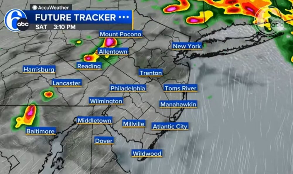
-

2026-2027 Super El Nino
TriPol replied to Stormchaserchuck1's topic in Weather Forecasting and Discussion
Hopefully there will be a big one in October! -
I just got woken up by a loud lightning strike. I love that. It looks like another round headed my way. AA County looks like the winner this morning. Headed your way, CAPE.
-

Saturday, July 18, 2026 Thunderstorm/Severe Weather Potential
WinterWolf replied to weatherwiz's topic in New England
We’ve been wet for sure…your area SW of here even a bit more…but all of us WOR have gotten our share. We’ll see what later today brings. -
Orioles only 2gb of the wild card?
-
1. The RRFS, which will replace NAM, has been developing this into a TS. 2. 0Z UKMET moves up TCG to 8PM Saturday and is stronger (winds almost to H strength Tue AM, which is high for the typically conservatively low UK) as it moves mainly slowly W to the NW GOM: NEW TROPICAL CYCLONE FORECAST TO DEVELOP AFTER 24 HOURS FORECAST POSITION AT T+ 24 : 27.1N 83.8W LEAD CENTRAL MAXIMUM WIND VERIFYING TIME TIME POSITION PRESSURE (MB) SPEED (KNOTS) -------------- ---- -------- ------------- ------------- 0000UTC 19.07.2026 24 27.1N 83.8W 1011 27 1200UTC 19.07.2026 36 27.6N 84.5W 1008 30 0000UTC 20.07.2026 48 28.0N 85.0W 1004 30 1200UTC 20.07.2026 60 27.9N 85.1W 1002 33 0000UTC 21.07.2026 72 28.0N 85.4W 999 37 1200UTC 21.07.2026 84 28.9N 85.5W 997 46 0000UTC 22.07.2026 96 29.1N 85.4W 993 56 1200UTC 22.07.2026 108 29.6N 85.4W 995 59 0000UTC 23.07.2026 120 29.2N 86.1W 996 53 1200UTC 23.07.2026 132 28.6N 87.2W 999 44 0000UTC 24.07.2026 144 28.0N 88.6W 998 41 1200UTC 24.07.2026 156 27.6N 89.9W 999 39 0000UTC 25.07.2026 168 29.0N 91.4W 1002 35
-
lol - the Nats are beating the A's 23-2 in the 9th.
-

2026 Mid-Atlantic Severe Storm General Discussion
AmericanWxFreak replied to Kmlwx's topic in Mid Atlantic
...Days 4-6/Mon-Wed -- Great Lakes/Midwest to the Mid-Atlantic/Northeast... A shortwave upper trough initially over the Canadian Prairies and northern Plains will develop east/southeast across the Upper Midwest/Great Lakes on Monday, then the Ohio Valley and Mid-Atlantic vicinity on Tuesday. Meanwhile, another upper shortwave trough will develop across the Great Lakes to the Northeast/Mid-Atlantic on Wednesday. These features will support enhancement of mid/upper level flow as a surface low tracks across Ontario/Quebec and New England during this time. A trailing cold front will likewise progress east/southeast over this three day period, with a very moist and unstable airmass present ahead of the front. This overall pattern will likely bring multiple days of severe storm potential from the Upper Midwest/Great Lakes to portions of the Ohio Valley, Northeast and Mid-Atlantic vicinity Monday through Wednesday, necessitating severe probabilities. While these areas may shift some over the coming day as the timing of mesoscale features and influence of prior days convection becomes more clear, these general regions are most likely to see at least isolated to widely scattered damaging wind potential as the upper trough and surface cold front sweep across the area. -
The timing on tonight's HRRR and NAM3km is around 2 to 4 in the afternoon, and they really hammer us with a big line of strong storms. I'm looking forward to big storms with heavy rain, but hopefully it won't be so severe that there's a lot of damage. Obviously the potential for that is there though.
-
Interesting how dry it is off the SE coast and Gulf. Tropics look shutdown for the time being.
-
Just saw my first back-to-school commercial from Kohl’s. Better get your Halloween candy before the shelves are empty.
-
 I recently discovered [url=https://mexicanrxnews.top/#]MexiMedsExpress[/url] and I can confirm they offer excellent prices for uninsured buyers.
 -
I recently discovered [url=https://mexicanrxnews.top/#]MexiMedsExpress[/url] and I can confirm they offer excellent prices for uninsured buyers.




.thumb.JPG.418e8a9a2902ae687ec35ff4bc0e038e.JPG)