All Activity
- Past hour
-

February 2026 OBS & Discussion
donsutherland1 replied to Stormlover74's topic in New York City Metro
It will turn somewhat cooler to close the week. Temperatures will mainly top out in the middle to upper 30s on Thrusday and Friday. Thw weekend will see highs in the upper 30s and lower 40s. It could become even milder with highs in the lower to perhaps middle 40s next week. Precipitation could arrive on Sunday or Monday. The ENSO Region 1+2 anomaly was +0.3°C and the Region 3.4 anomaly was -0.5°C for the week centered around February 4. For the past six weeks, the ENSO Region 1+2 anomaly has averaged -0.25°C and the ENSO Region 3.4 anomaly has averaged -0.52°C. La Niña conditions will likely continue into at least late winter. The SOI was -1.20 today. The preliminary Arctic Oscillation (AO) was -1.676 today. Based on sensitivity analysis applied to the latest guidance, there is an implied near 91% probability that New York City will have a cooler than normal February (1991-2020 normal). February will likely finish with a mean temperature near 31.5° (4.4° below normal). Supplemental Information: The projected mean would be 3.8° below the 1981-2010 normal monthly value. Overall, Winter 2025-2026 is on track for a seasonal mean temperature of 31.9°. That would be the lowest winter mean temperature since Winter 2014-2015 when the mean temperature was 31.7°. Winter 2025-2026 would only become the fourth winter of the 21st century with a mean temperature of 32.0° or below. -
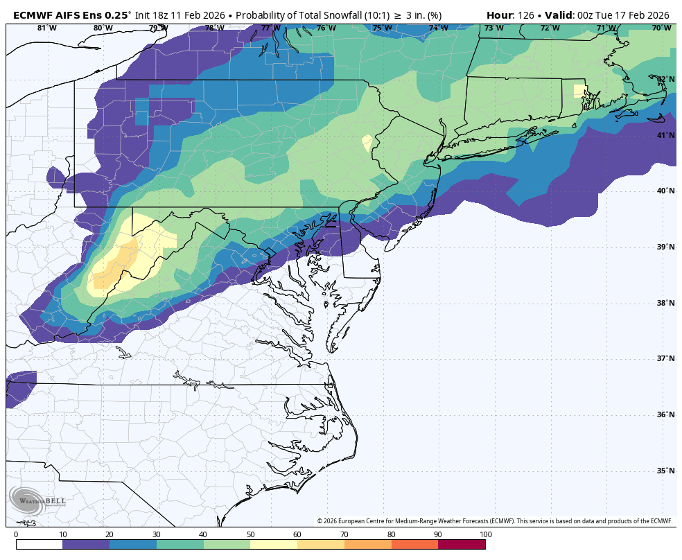
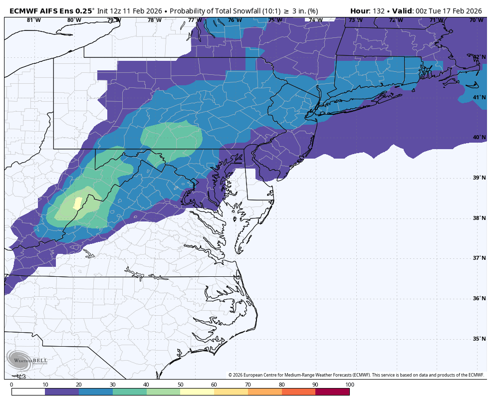
What’s up with the AIFS, it’s so damn snowy. 4-6” mean Monday then another several inches the following 10 day. As a 12-18” total mean for all of New England about the highest all year.
-

Is we back? February discussion thread
VivaManchVegas replied to mahk_webstah's topic in New England
Snow begets snow.. still snowing. I did not see this at all. 1/2" now. -
Bursts of heavy snow in these squalls
-

February 2026 Medium/ Long Range Discussion: 150K Salary Needed to Post
Ruin replied to Weather Will's topic in Mid Atlantic
what im saying most of the cold we had was a waste -

February 2026 OBS & Discussion
PhiEaglesfan712 replied to Stormlover74's topic in New York City Metro
That snow event on May 9 showed the wasted potential of 1977. That could have been an all-time season if March and April didn't torch. As it stands, 1976-77 was a record cold fall and winter. -

February 2026 OBS & Discussion
North and West replied to Stormlover74's topic in New York City Metro
. -
Nope. But I have a valid excuse. I was 3 months old.
-

February 2026 Medium/ Long Range Discussion: 150K Salary Needed to Post
CAPE replied to Weather Will's topic in Mid Atlantic
This is all silliness and has no relevance to what actually occurs. Weather does what it does when it does. Doesn't give a fuck about weekend rules or whatever else. -

Feb 10-11 Mid Week Minor Event - Ride the hot hand?
HoarfrostHubb replied to HoarfrostHubb's topic in New England
Refreshments being served here. -

Feb 10-11 Mid Week Minor Event - Ride the hot hand?
klw replied to HoarfrostHubb's topic in New England
A surprise 2.3 during the day brought total to 5.0 -
YES It’s so wild to me that I’m approaching 120” on the season with only two winter storm warnings.
-

Winter 2025-26 Medium/Long Range Discussion
Brian D replied to michsnowfreak's topic in Lakes/Ohio Valley
's on board -
It’s ironic how these bouts of upslope go essentially unforecasted but add up to what would have been a winter storm warning
-

Winter 2025-26 Medium/Long Range Discussion
McHenrySnow replied to michsnowfreak's topic in Lakes/Ohio Valley
We are so back.
-
Wait til that sun angle gets crankin
-
fat fluffy flakes with this band coming through
-

February 2026 OBS & Discussion
CPcantmeasuresnow replied to Stormlover74's topic in New York City Metro
May 9 2020 we had on and off snow showers most of the day. Even NYC picked up a trace. I received almost an inch during one of the squalls with the green grass and cherry tree blossoms almost getting covered. 34° and heavy snow during the afternoon of May 9. I'd only seen that one other time up around here and that was the 1977 May 9 snow event. That was much worse than the 2020, or better depending on perspective. Personally I loved it. -
Oh, I get it. I love the effort you put in to all of this and I’m sure it must get emotionally draining.
-

Is we back? February discussion thread
RUNNAWAYICEBERG replied to mahk_webstah's topic in New England
Don’t do it -

Is we back? February discussion thread
40/70 Benchmark replied to mahk_webstah's topic in New England
Well, March did the trick just bc of the sun...pack rotted. -
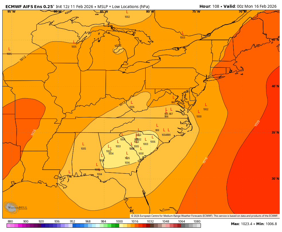
I haven't given up yet. The track keeps me intrigued, and the moving parts (maybe something will go right for once instead of wrong as with recent NC storm). And the simple fact that we have barely gotten any moisture since the snow/sleet beatdown storm. But like with the Euro image i posted above, I'm very worried about temps for my backyard even if the track trends toward "perfect." Silver Spring doesn't do marginal well.
- Today
-
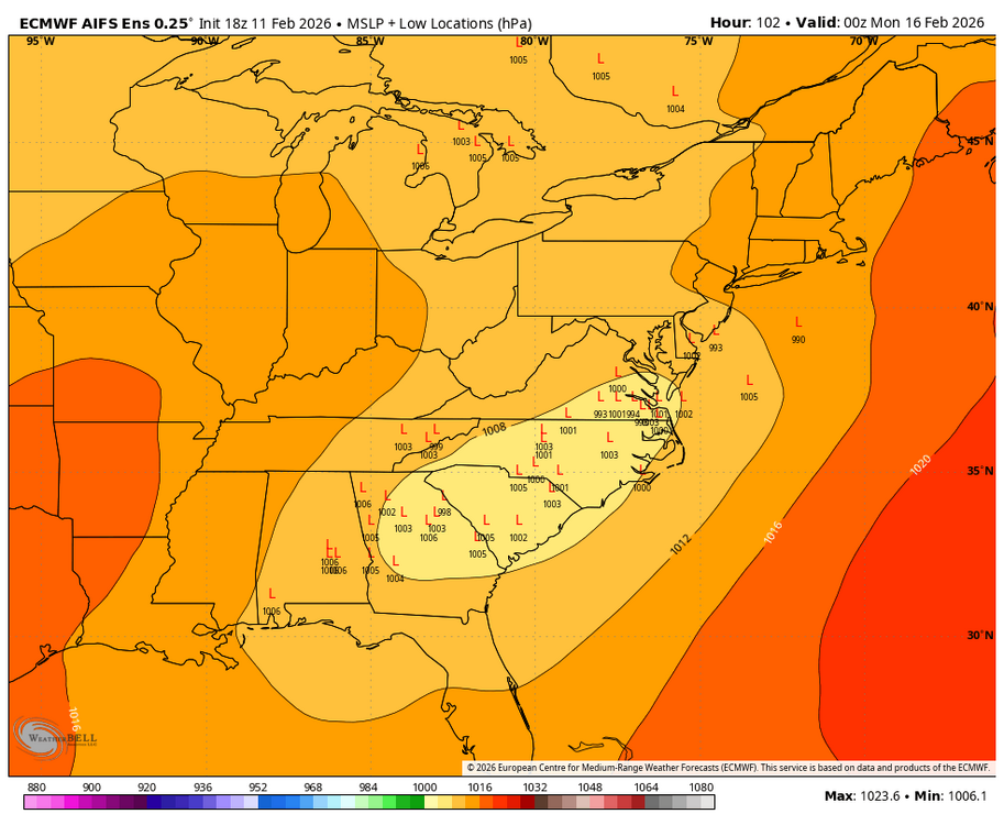
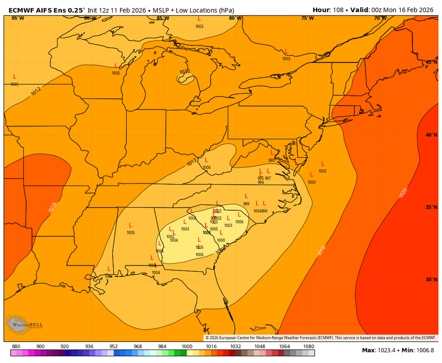
I guess everyone including myself gave up on the weekend, but at 18Z pretty significant jump North on the AI EURO that everyone loves. Also, a significant jump in snow prob. (Comparison to 12Z).


-
Noone is afraid to hear it. We're just exhausted by your insufferable, boorish repetitiveness.
-
You need a phased, strong system to get enough dynamic cooling for snow.


.thumb.png.4150b06c63a21f61052e47a612bf1818.png)