All Activity
- Past hour
-
It's all dangerous in the end. The prefixes and adjectives used these days is out of control. My biggest pet peeve is "catastrophic." It's always that now. You never see, "severe," "heavy," or "disastrous," referring to impact or damage. Impact and damage are scalable, but we choose to throttle to the max all the time. That's counterproductive in the end. More is not always better.
-

E PA/NJ/DE Summer 2026 Obs/Discussion
RedSky replied to PhiEaglesfan712's topic in Philadelphia Region
This will be epic I'm stoked -

E PA/NJ/DE Summer 2026 Obs/Discussion
Birds~69 replied to PhiEaglesfan712's topic in Philadelphia Region
Chris Sowers (Winter weenie) is back in Philly after a short move to Fla. And on FB.... https://www.phillyburbs.com/story/news/local/2026/05/14/philly-weather-guy-chris-sowers-is-returning-will-he-be-back-florida-6abc-west-palm-beach/90074898007/ Upcoming heat wave: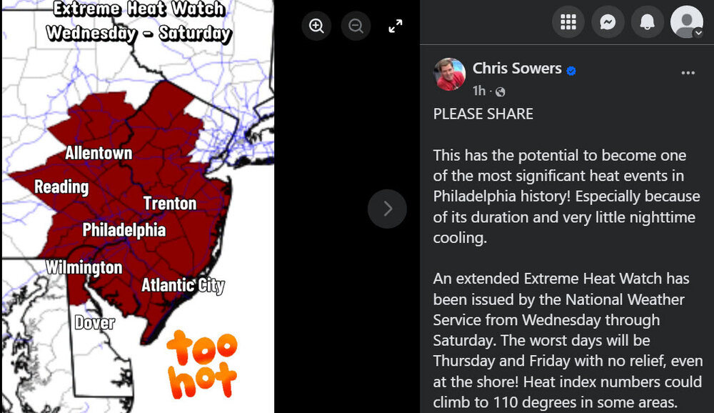
-
Thankfully it didn't stop us from having a cold/snowy winter.
-
The thing in this case, it's not a uniform slam dunk. This is not a classic Bermuda High set up, nor it is a dry solid sfc NW flow (a la Aug 2, 1975). Eastern and western sections need to be treated differently. You can't just gloss over it all. The difference between 90 and 100 deg readings is non-trivial. You can't just say "hot" and leave it at that. There are important details to be worked out here. The above factors preclude going high-end record heat across the board at this range still. Of course, the MSM doesn't treat it this way. HOT HOT HOT and the world is ending....
-
 Let's dew it.
 -
I knew you were showing praise. I just wanted to make sure I have not stirred the pot somehow w/ a previous post and it resulted in a tangent issue.
-
What streak?
-
honestly with the dry soil and the right wind direction, we can sneak one in if we are in the upper 90s by 1pm. It happened a couple weeks back
-
12Z UKMET is fairly similar to the 0Z: TD that stays weak and then dissipates well offshore: MET OFFICE TROPICAL CYCLONE GUIDANCE FOR NORTH-EAST PACIFIC AND ATLANTIC GLOBAL MODEL DATA TIME 1200UTC 28.06.2026 NEW TROPICAL CYCLONE FORECAST TO DEVELOP AFTER 48 HOURS FORECAST POSITION AT T+ 48 : 32.1N 72.3W LEAD CENTRAL MAXIMUM WIND VERIFYING TIME TIME POSITION PRESSURE (MB) SPEED (KNOTS) -------------- ---- -------- ------------- ------------- 1200UTC 30.06.2026 48 32.1N 72.3W 1013 25 0000UTC 01.07.2026 60 31.4N 72.5W 1012 24 1200UTC 01.07.2026 72 31.0N 72.8W 1013 22 0000UTC 02.07.2026 84 31.2N 74.4W 1014 20 1200UTC 02.07.2026 96 31.6N 75.7W 1015 17 0000UTC 03.07.2026 108 CEASED TRACKING
-
I remember playing little league baseball in 100 degree temps. It was awful.
-
My AC isn't working right
-
Very much depends on what shit the bed on it. Anywhere from $250—$3,000
-
Send me seeds. Along with a jackhammer to get them into what was once soil.
-
Isn't it fair to say that vortex 95 has been handed the baton by BrooklynWx99 ?
-
Desert grass. Hardy stuff. Thrives there. You should give it go!
-
We roast. Figures my cars AC basically s*** the bed! Who knows hiw much to fix that.
-
What streak is that? DCA hit 100 just a couple weeks ago.
-
Extreme Heat Watch issued for the entire OKX forecast area
-
There's some kind of grass vegetation in your pic. Totally unrealistic for here. Extinct years ago.
-
There are some storms over Falls Lake now so hopefully that can help a little.
-
Wanna trade profile photos? I think my yard can still support cactus growth.
-
Maybe I can beat the 95 I had in Mayorch
-
Had some rain yesterday and a lot of rain and storms today. Still a bit rainy today with a temp of 65 degrees. I thought we were going to be burning alive by now. Also this upcoming heatwave keeps getting adjusted down here....