All Activity
- Past hour
-
We should be so lucky.
-

January 2026 regional war/obs/disco thread
NoCORH4L replied to Baroclinic Zone's topic in New England
So how damaging do we think this mild up will be? It seems like the boundary might not get further north of the MA/NH border? -

January 2026 regional war/obs/disco thread
Go Kart Mozart replied to Baroclinic Zone's topic in New England
The Pivotal free site now has Euro Skynet ensembles with the continental view. BTW, after about the 11th or so...they look tasty. -
Eps have the SE Ridge at the end of the run too. This is at least the 3rd run in a row on the 360hr runs. It's maddening.
-

January 2026 regional war/obs/disco thread
Snowcrazed71 replied to Baroclinic Zone's topic in New England
Here's just another forecast from another MET Ross Elliot out of Ohio. **Weather Nerd Alert: Next Week’s Warmth Is A Warning Sign From Old Man Winter** I have seen a lot of flashy headlines in the past 24 hours on social media that are either misleading or flat out wrong. Yes, we will warm up next week. No, winter isn’t over, and I would not describe what is coming as “A January Heat Wave” either as highs will be in the 40s. In fact, if you hate winter, I would not get too excited for the coming warmth. If you understand what will drive the mild pattern, then you also understand the warmth would be temporary, and it is likely a warning sign of a big arctic blast and potential for bigger winter storms. So what is going on behind the scenes? The pattern so far this winter has generally mimicked what we have today, below normal temperatures in the Great Lakes to the Northeast, warm out west, and extremely cold in Alaska and the Yukon. Nobody up that way wants to hear, “it is Alaska, what do you expect?”. The interior of Alaska just had their coldest December in 45 years. Fairbanks hasn’t been above 0 degrees F in nearly 3 weeks. Lows have been between -40 and -50F every day for the past week. That is not normal cold up that way. Meteorologists have been closely watching this pocket of extreme cold, because when it does start to move, it will have a big impact wherever it goes. The pattern is still locked in over the next 3 days, but after that we start to see a shift east with this entire global pattern. The warmth that is out west starts moving our way, and the trough over Alaska drops into the west. Alaska is the key to the long range forecast, and computer models move a ridge towards the state and it intensifies over the next two weeks. That would do two things. 1) It pushes the set up east. That means we get temporary warming that is in the western states, and in time that cold air in Alaska and western Canada finds a new home in the northern plains and Great Lakes, and eventually the northeast. 2) A strong ridge like what is forecast is also a blocking pattern that would stall out the weather pattern and also split the jet stream into a polar jet and a subtropic jet stream. This would increase the chance for bigger winter storms in the eastern half of the country as that pipeline of moisture would go across the Pacific, and pick up extra moisture from the Gulf. Meanwhile, the polar jet could drop into the Great Lakes bringing lots of cold. When you have this pattern, and the waves sync up, then you often get some bigger winter storms. There is no way of knowing where these storms will end up right now, but the pattern looks ideal for winter storms. At the very least, the cold looks to make a big comeback. In a nutshell, yes it will warm up next week, but be careful what you ask for as the same engine that is driving the warmth would also drive arctic cold our way after it and probably wintery precipitation mid to late January. This entire set up is connected. The screen shots below show the basic pattern as it shifts east over the next couple of weeks. -
Pivotal doesn't offer multiple days, so we can't get an apples to apples comparison.
-

January 2026 regional war/obs/disco thread
Typhoon Tip replied to Baroclinic Zone's topic in New England
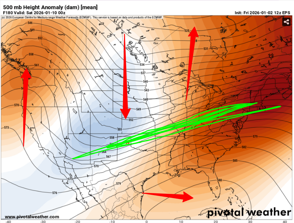
It's going be interesting what these smoothed ens mean cinamas look like on or around the 7th .. 8th. Both the EPS and GEPS 12z continued/agree in their idea of a +PNA blossoming by 270 hours, which then within just 3 or 4 days, retrogrades and/or repositions a new ridge in the EPO domain. In fact, the GEPs is rather exotic looking. In principle they agree on that evolution. The GEFs on the other hand offers a more tamed looking +PNA, which then moves and/or retrogrades into the hybrid position between the +PNA and -EPO; similar -EPO amplitude as the EPS way the hell out at the temporal horizon of fantasy range. But, all of these movies are after the big collapse in the N Pac out there in 4 or 5 days. -
Lmaooo none of that's even gonna be the same in 2 weeks lol
-
.thumb.jpg.6a4895b2a43f87359e4e7d04a6fa0d14.jpg)
Central PA Winter 25/26 Discussion and Obs
Yardstickgozinya replied to MAG5035's topic in Upstate New York/Pennsylvania
-
Uhhh…82-83 had a KU? 14-15 was a very good winter. 97-98 was a blowtorch super Nino. 06-07 and 18-19 were fair to good depending on location.
-

January 2026 regional war/obs/disco thread
dendrite replied to Baroclinic Zone's topic in New England
Enjoy your 0.03” water equiv -
Typical +TNH,while we get into wk2 of Jan,+PNA,Trough AXIS in the middle of the country,subtropical ridge builds over Florida and the JET is well north of the Tn Valley,i actually thought we'd have a chance last week to maybe have somewhat a better pattern,but even tho it looks good in East Asia,other teleconnections still play a part in NA,so this time seemingly might not work out well for us
-
Sun finally out and temp up to 32. Not going to get close to the forecast high of 38 lol
-
Lemme guess, he's the guy who's lights are on before Thanksgiving.
-

January 2026 regional war/obs/disco thread
ORH_wxman replied to Baroclinic Zone's topic in New England
I thinbk those are every 6 hours...but yeah, there's plenty of warmish days in there. 46 next week and some other 40s smattered around in there -
I don't think any of the analogs that Webber has listed below were particularly good winters in these parts.
-

January 2026 regional war/obs/disco thread
weathafella replied to Baroclinic Zone's topic in New England
Verbatim the 54 and 49 days consecutively mid January -

Central PA Winter 25/26 Discussion and Obs
Festus replied to MAG5035's topic in Upstate New York/Pennsylvania
My annual tradition of noting tomorrow is Perihelion day - the Earth is closest to the sun officially at 12:15 EST. And as a double bonus, tomorrow is also a supermoon (full moon while the moon is at or near perigee). This combo won't happen again until 2045. So when that time rolls around, be sure to tell your kids (or grandkids, or great-grandkids, or anyone who will listen) that you were there in 2026 and it was a rollicking event. -
That all looks pretty good at H5. But keep in mind that the Midwest only barely cools back down to NN briefly at best during these periods on that Euro run with AN dominating. And the GFS never even gets down to NN. Hopefully, the Euro and especially the GFS will cool off substantially on the ground in the Midwest as we get closer just as occurred for as recent periods as 12/28-today.
-

January 2026 regional war/obs/disco thread
weatherwiz replied to Baroclinic Zone's topic in New England
Hopefully because of this prolonged cold a number has been done on the tick population -

Winter 2025-26 Medium/Long Range Discussion
DocATL replied to michsnowfreak's topic in Lakes/Ohio Valley
lol…I figured that was coming. -
January 2026 regional war/obs/disco thread
Snowcrazed71 replied to Baroclinic Zone's topic in New England
I've looked at several posts from different meteorologists around the Northeast. They all say this warm up next week is temporary. They also say snow will be back in our forecast. This is normal and we should always get a warm up at some point in a winter season. Too many people are freaking out like it's the end A winter ( and there are some that wanted to be the end and like to cause chaos ). We just have to hang in there and it will be back. -
That's the storm I need to win the snowfall contest. No chance.
-
Everyone good
-
Put it all on black? No, put it all on p18.


