All Activity
- Past hour
-
FWIW....DT from Wxrisk posted this WXRISK VIEW: There is the potential for a wave of LOW pressure to develop on the front but the question is how close to the coast. Most of the models for the past few days have been keeping this weak LOW well off the coast but the Trend started early WED with the GFS and the European AI models. DISCUSSION/ MAPS Last week in the newsletter I mentioned three specific winter storm threats between the period from January 15–30. AS i stated on SUNDAY the first threat of January 15- 16 is gone. A stronger arctic cold front will sweep through the Midwest and reach the East Coast on Saturday January 17. This cold front appears to be much stronger and looks like it will bring snow showers to much of the Middle Atlantic region even into the Piedmont as far east is I — — 95 from NYC to Richmond. It would not surprise me to see an 1–2 inches of snow in the Shenandoah Valley., the mountains of PA, western MD, WV, southwest VA, and the mountains west in NC.
-

January 2026 regional war/obs/disco thread
radarman replied to Baroclinic Zone's topic in New England
It did the coup de grace on the ice in my driveway so I was grateful for that. Only about 25% snow coverage left but looks to be back by Saturday night. -

Winter 2025-26 Short Range Discussion
OHweather replied to SchaumburgStormer's topic in Lakes/Ohio Valley
The models hinted at this on Sunday and then completely backed off, and never caught back up until the snow was almost over. Maddening as an operational met, splendid as a snow lover. My best explanation is that models were not properly initializing with the vort max that dove in from the Arctic, as everything associated with that (starting with the overperforming squalls in the Chicago area this morning) has over performed with this system. -

First Legit Storm Potential of the Season Upon Us
The 4 Seasons replied to 40/70 Benchmark's topic in New England
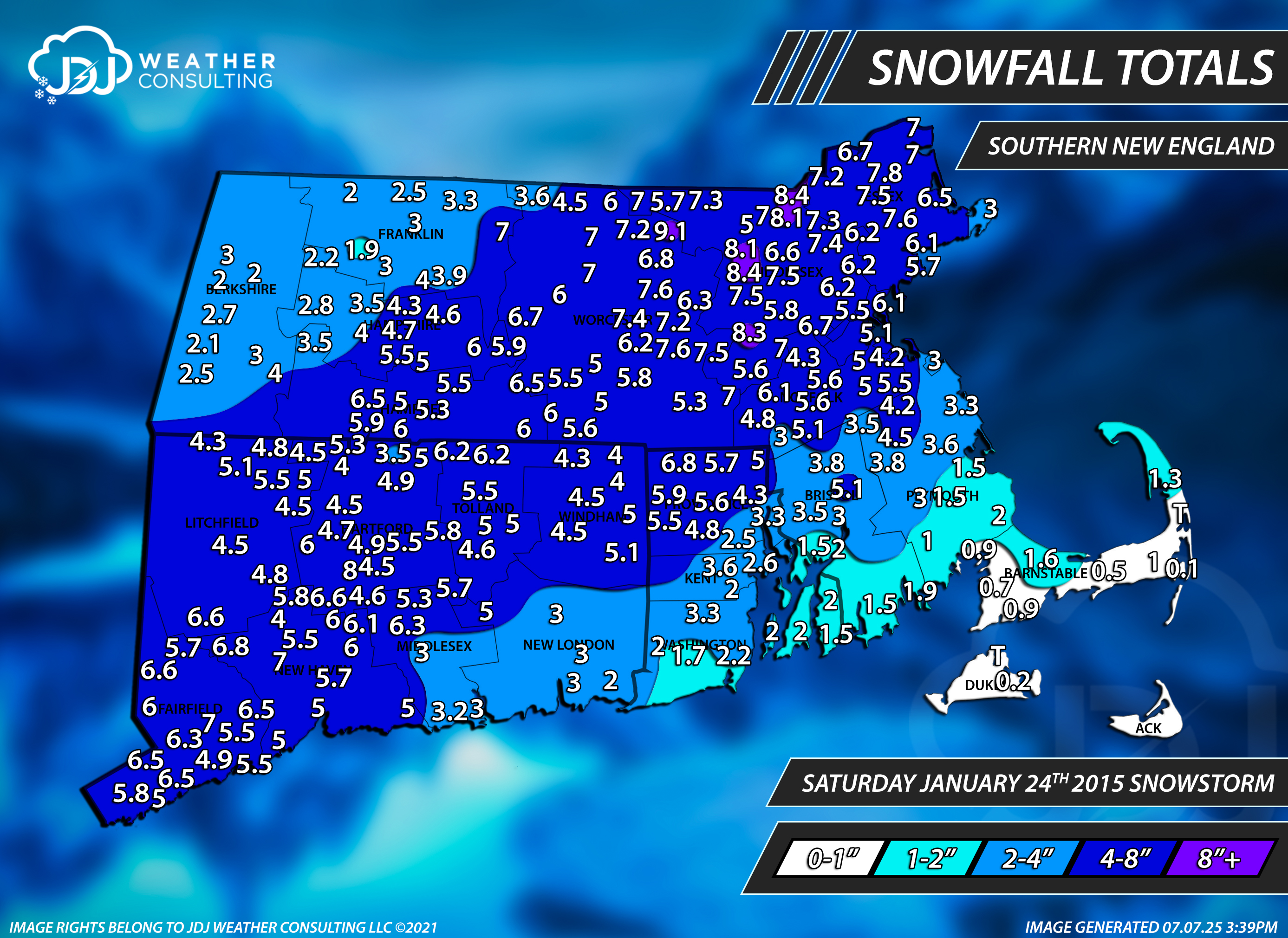
OK fair enough but calling it a 1-3 event when the whole state got 4-8 save New london middlsex Co is objectively wrong. The literal only report under 3 was Stonington. Picked up about 6 here. It was pure paste and a very solid base for the long duration snow pack
-

Winter 2025-26 Medium/Long Range Discussion
Chambana replied to michsnowfreak's topic in Lakes/Ohio Valley
Been a few years since we’ve had a GHD sub storm. What number are we on? IV or V? -

2025-2026 Fall/Winter Mountain Thread
Buckethead replied to Buckethead's topic in Southeastern States
I had the same idea but poured a jack and coke. It really feels like 28 out here lol. Sent from my Pixel 10 Pro using Tapatalk -

2025-2026 Fall/Winter Mountain Thread
Maggie Valley Steve replied to Buckethead's topic in Southeastern States
It's currently pouring snow at Cataloochee with very gusty winds. It's coming. -
Sounds right. They're on 11 mile just NW of the Detroit metro area so that tracks.
-

Winter 2025-26 Short Range Discussion
Powerball replied to SchaumburgStormer's topic in Lakes/Ohio Valley
Are you on the east or west side of South Bend? -
This storm is the harbinger of our fading Nina pattern shift. I've got a good feeling about this one.
-

January 2026 Medium/Long Range Discussion
Stormchaserchuck1 replied to snowfan's topic in Mid Atlantic
My friend said there's a report of 6" NW of Detroit. I would guess it's a deeper 500mb as the low looks organized on radar. See how it does for the later storms in the next few model runs.. -
Yeah I am about to pour a pitcher of beer and jump in the hot tub. Hopefully we switchover down here. Radar looks very juicy upstream for NWF. One of the better flows I have seen coming in on radar this year so let’s see if it verifies.
-
euro dosent jump from flurries to a blizzard in one run like the gfs does
-
2025-2026 Fall/Winter Mountain Thread
Maggie Valley Steve replied to Buckethead's topic in Southeastern States
Same! Temperature has finally fallen to 37. -
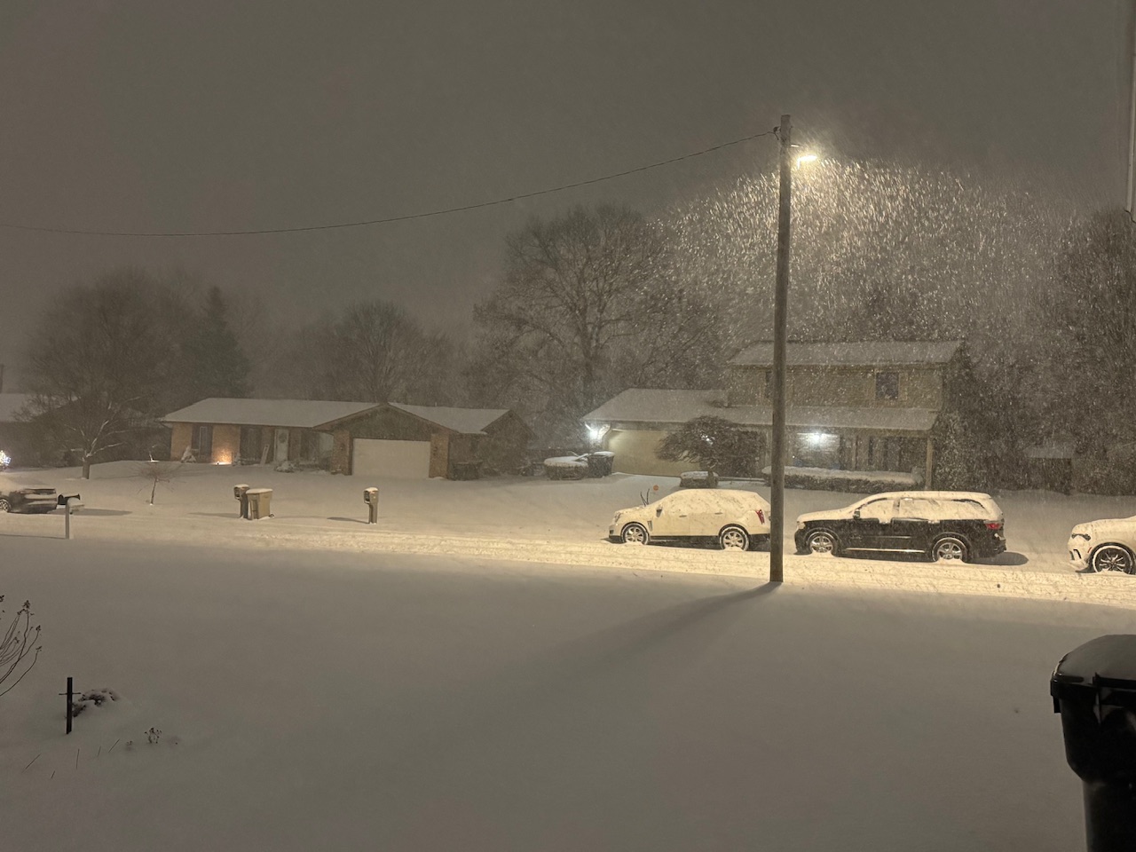
Image?
-
EPS is not positive. Fine for those from the FL panhandle to SE VA though. EPS is the gold standard in my book and unless it starts making big changes in the next 24 hours I’d bet that those of us to the north and west will end up disappointed yet again.
-

First Legit Storm Potential of the Season Upon Us
WinterWolf replied to 40/70 Benchmark's topic in New England
We only got close to 4” here…we(you and I)were actually in touch that late evening. But it was upper3’s to 4” here in Southington. Not remembering wrong for my house. You did better than I did in that. -
Winter 2025-26 Short Range Discussion
Chambana replied to SchaumburgStormer's topic in Lakes/Ohio Valley
Judging from radar you are in the goods right now. Congrats dude, keep us all updated. That band looks super intense. -
Great seeing the Euro jump west! Bring on 0z!
-

First Legit Storm Potential of the Season Upon Us
ORH_wxman replied to 40/70 Benchmark's topic in New England
I went to see a Garth Brooks concert that Saturday night and as we got into Boston, the backlash started and temps dropped like 10 degrees. Everything went from sloppy mess to frozen with 3” of powder on top. Was a really wintry scene in town that night. Of course, I was weenieing out the entire time during the concert checking the NAM, then the RGEM, etc as the 00z runs came in and that’s when they turned it into a monster HECS. The 12z runs had already gone into a moderate event. -

Pittsburgh/Western PA WINTER ‘25/‘26
TheClimateChanger replied to Burghblizz's topic in Upstate New York/Pennsylvania
Here's what it's going to look like if that GFS fantasy storm from last night comes true. -
The 18z GFS has some snow, but not nearly the amount it did on the 12z. Will the next run go further east or west? It has been all over the place.
-

Winter 2025-26 Short Range Discussion
sbnwx85 replied to SchaumburgStormer's topic in Lakes/Ohio Valley
Up to 6” and still ripping. Probably 2-3” per hour rates.
-

Winter 2025-26 Short Range Discussion
TheRegionRat replied to SchaumburgStormer's topic in Lakes/Ohio Valley
Snowed really hard at work in Hammond. Started as a mix, dropped some sleet, then snow. Unsalted areas remain icy. The further south you went, the more snow. At home, I have less than inch. The US 30 corridor has 3 inches or so. While the squall moved through visibility was awful. It was tough going from around 8AM through 9:30 or so. -
Pittsburgh/Western PA WINTER ‘25/‘26
TheClimateChanger replied to Burghblizz's topic in Upstate New York/Pennsylvania
Yeah, they were getting clobbered with moderate to heavy snow earlier.