All Activity
- Past hour
-
There is snow on the beach at OCMD this am.....pull up a webcam!
-

January 2026 regional war/obs/disco thread
ORH_wxman replied to Baroclinic Zone's topic in New England
I’ve had one double digit storm (and it was barely double digits) since Feb 2022. This truly feels like that 1988-1992 stretch except warmer (at least prior to last winter) and not quite as paltry on seasonal snow totals here…but close enough. Really could use a big storm to break the drought. -

January 2026 regional war/obs/disco thread
dendrite replied to Baroclinic Zone's topic in New England
Maybe we risk some cutters, but I’m only interested in big ticket items. -
January 2026 regional war/obs/disco thread
ORH_wxman replied to Baroclinic Zone's topic in New England
Monday doesn’t look that interesting unless northern stream digs a little more for a stronger IVT. Otherwise prob flurries or C-1”. -
January 2026 regional war/obs/disco thread
dendrite replied to Baroclinic Zone's topic in New England
In their defense, the southern plains ridge started as a SE ridge in the distant LR as well before trending more west. Difference is, it seems the ens are trying to flush the cold in eastern Canada this time. I would roll with this…in the interior at least.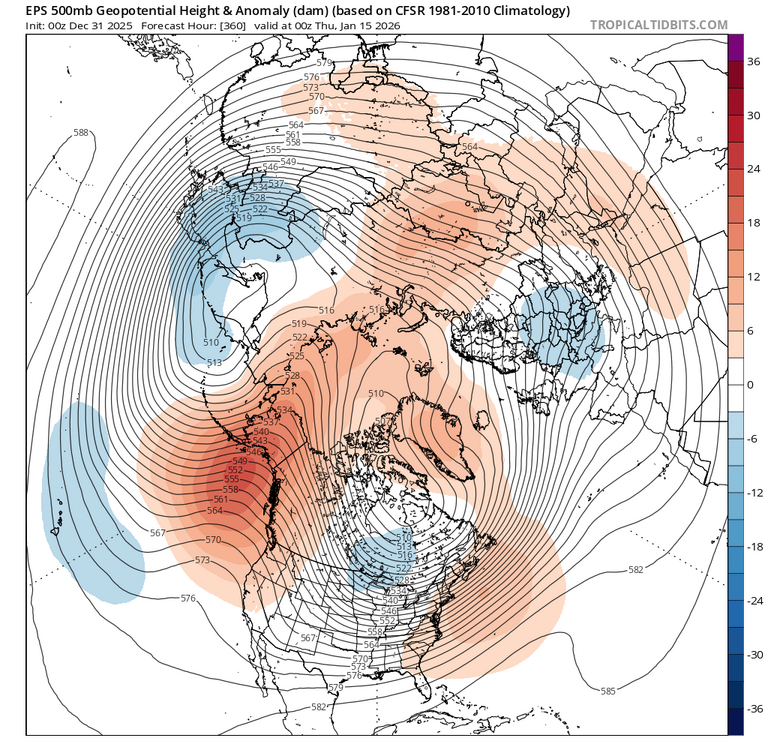
-

Central PA Winter 25/26 Discussion and Obs
pasnownut replied to MAG5035's topic in Upstate New York/Pennsylvania
3 days in a row. yeah...my wires dont alwasy touch. My cheeks look like santas after his annual trek round the world. Takin today off. Lotsa miles on my boots and I'm not compainin. Glad that I can do it. Today was total gym and ab roller (done), so now headed into work for a couple hours (even though I'm technically "off"). To all my pals here, happy NYE, and all the best in the New Year. -

January 2026 regional war/obs/disco thread
Damage In Tolland replied to Baroclinic Zone's topic in New England
Tonight’s is 2 -4 there . Another 2-4 Monday.. then we’ll see mid week . Hopefully you have a Ring so you can watch it vicariously -
Agreed. Right now the south East Ridge has been pushed back quite a bit so any storm that comes towards our area would likely not be interfered by that ridge and we would not run the risk of the storm being amplified too much and cutting to our west. Instead, our current problem is that we don’t have enough amplification because the northern stream is just flowing too fast and cannot phase with the southern stream in time to lead to a large coastal storm. However, it looks to be towards mid month that there is a shake up in the Pacific, which will push the mild air in the west and central US over the east US briefly. Then afterwards we will appear to be in a more of a colder regime similar to what we are in now but this time the cold will be more widespread across the US. While that will likely increase the chances for snow because our snow storms will have already been formed to our west and traverse across the US, we do run the risk of a larger southeast Ridge, which would lead to potential over amplification and temperature issues during those storms. So for now, we have the cold, but we don’t have the snow, and in a few weeks it’s looking like we might have the cold, but we have issues with the southeast Ridge, which will of course affect our chances for snow as well. Either way, we need a big shake up in the Pacific because most of the US is snapping back to warm and dry for the foreseeable future, which doesn’t go well for our chances either.
-

January 2026 regional war/obs/disco thread
CoastalWx replied to Baroclinic Zone's topic in New England
I’ll be fine missing an inch. Looks quiet to me. -
January 2026 regional war/obs/disco thread
Damage In Tolland replied to Baroclinic Zone's topic in New England
Snow tonight, snow Sunday night/ Monday and snow Jan 6. Wouldn’t call that quiet. You’ll miss a few snowfalls -
January 2026 regional war/obs/disco thread
CoastalWx replied to Baroclinic Zone's topic in New England
Yeah verbatim I don’t think it would be prolonged, just saying it looks to happen. Seems like a quiet 7 days coming up. -
January 2026 regional war/obs/disco thread
Damage In Tolland replied to Baroclinic Zone's topic in New England
There’s been no SE ridge all winter -
I’m a little less lighter on my feet these days with two little boys in tow but we made their (3 and 1) inaugural unplanned snow run to Canaan with me. Blackwater Falls State Park this morning. 4-6 inches last 24 hours (still falling- IT JUST SNOWS HERE) with another 6-10 expected overnight.
-
I clouded over around 3 am and the flurries returned. It WAS 18.3 around 2 am, climbed once those clouds filled in. Up to 24.4/16.7 at 8 am here.
-
19.6 this morning. Enjoy this last day of 2025.
-
To add to this, IF said +TNH pattern (-EPO/+AO/+NAO/SE ridge) develops just after mid-month into late January, it would argue for overrunning events and SWFEs. The question then becomes does it favor New England? Or PHL/NYC north into New England?
-
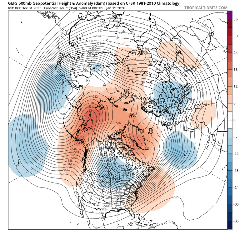
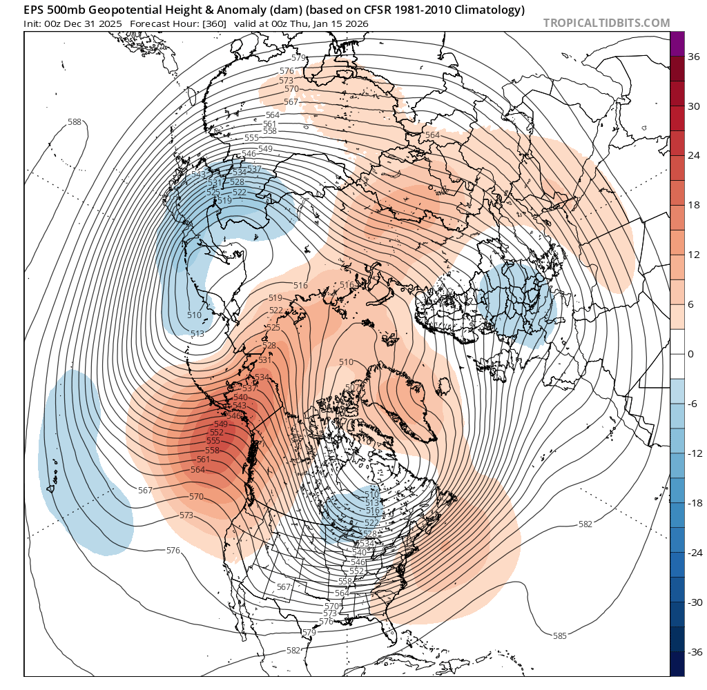
12z Eps run 500mb anomaly map Cape posted Monday evening on top for 0z 1/9. Last night's run of the Eps only 36 hours later on the bottom. More evidence the reliability of ensembles can match that of operationals.
.thumb.png.228ee81e4eeb7a973a98390ac52366b9.png)
.thumb.png.89ae33b3246de2f962b8eb9fc21113ac.png)
-

January 2026 regional war/obs/disco thread
Modfan2 replied to Baroclinic Zone's topic in New England
I would take 40 and sun at this point -

January 2026 regional war/obs/disco thread
Cold Miser replied to Baroclinic Zone's topic in New England
5” total for me will do it for December (and the season so far). Hoping for a good January. -
New Years Day 2026 - 1st snows of the new year possible
Cold Miser replied to Baroclinic Zone's topic in New England
Ha. Psychostick. I saw them live back in September. Funny dudes. -

January 2026 regional war/obs/disco thread
WinterWolf replied to Baroclinic Zone's topic in New England
It did. Very Short lived though. I feel this will be too. Anyway, go have fun in the sun, and stay off your phone. We’ll hold down the fort for you. -
This dropped to 13.9 at 7:30! , excellent radiational cooling.
-
Great job. For some reason, this type of pattern has preceded or accompanied El Niño development. So it will be interesting to see how things go since this has been the most amplified version of the pattern we have seen in December. Less amplified versions of this December pattern 1996…..1997-1998 super El Nino 1981……1982-1983 super El Niño 1980….weak El Nino 1977…..weak El Niño 1958…..strong El Niño winter before 1957…..strong El Niño
-
Because its the 84 hour NAM - would be interesting if it ends up leading the way.........the 06Z run is not giving up the northward track yet
-

Winter 2025-26 Short Range Discussion
cyclone77 replied to SchaumburgStormer's topic in Lakes/Ohio Valley
Looking like mostly rain here on the far southwest edge of today's wave.


.png.c5a3ab49ef18f51439801edf5e2546f2.png)
.png.4c66adeb504742e2026257cbc59cf151.png)


