All Activity
- Past hour
-
Just saw a video from a met from NH of the Saco. She had never seen it so low.
-
Meh
-
-
I have the WS-5000 and have had no complaints. In fact, with Energizer Lithium batteries I somehow have yet to have to change ANY of the sensor batteries...and it's been over 2 years I think. Has to happen eventually....they just keep going. I have a few temp sensors, a lightning one. Never installed the rain gauge because I don't have a good spot, and the wind direction is unreliable because it's not sighted properly - but for everything else it's been fantastic. The power supply for the console went haywire and died recently but got an Amazon replacement and it went back to normal.
-
Heading down to Karns for high school football this evening. It looks like the storms will arrive here after Friday night lights are done. At least I hope so.
-
@North Balti Zen Glad I could help! Lots of choices out there, but that Ambient is best bang for what it delivers and the accuracy component of it all. I know you want as close to perfect as possible, so that is a solid choice! I think you'll love it!
-
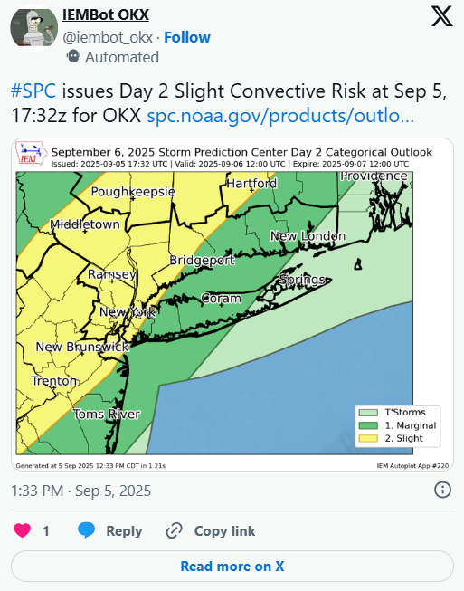
Sniffed this out firstly on Monday! Some knew ...Northeast... A wave of low pressure is forecast to develop over eastern PA early in the day, translating northeastward along the front and into ME by late afternoon. Stronger heating and steep low-level lapse rates should develop from VA into eastern PA/NJ and into interior southern New England, with MLCAPE around 1500 J/kg as an areal average. As the warm air mass develops and accelerates north ahead of the cold front, both instability and shear parameter space will become favorable for severe storms, including supercell potential. A line of storms is expected by 17 to 18Z, from eastern PA toward the Hudson Valley, expanding N/S and pushing east through the afternoon. Given 40-50 kt effective deep-layer shear and enhanced low-level shear with the midday surface theta-e surge, the initial storm mode may be cellular along the boundary, with a brief tornado or two possible along with some hail. Damaging winds are then most likely as outflows merge, and spread east across the remainder of the region through late afternoon.
-

O'Brother Septorcher
Prismshine Productions replied to Prismshine Productions's topic in New England
Same, .3 here Sent from my SM-S166V using Tapatalk -
If I were running the team, I would trade Jalen Carter as soon as possible, hopefully get a lot of picks out of it, and let someone else pay him in the offseason (and be their problem). We should have kept CJGJ instead. The difference between CJGJ and Carter is that CJGJ knows where the line is, and doesn't cross it. Can't say that about Carter.
-
My thought hasn’t changed on that so far. Although I was on board with 91L developing, I still think the basin overall will continue to be hostile until mid September or more likely after the 20th.
-
zzzzz
-
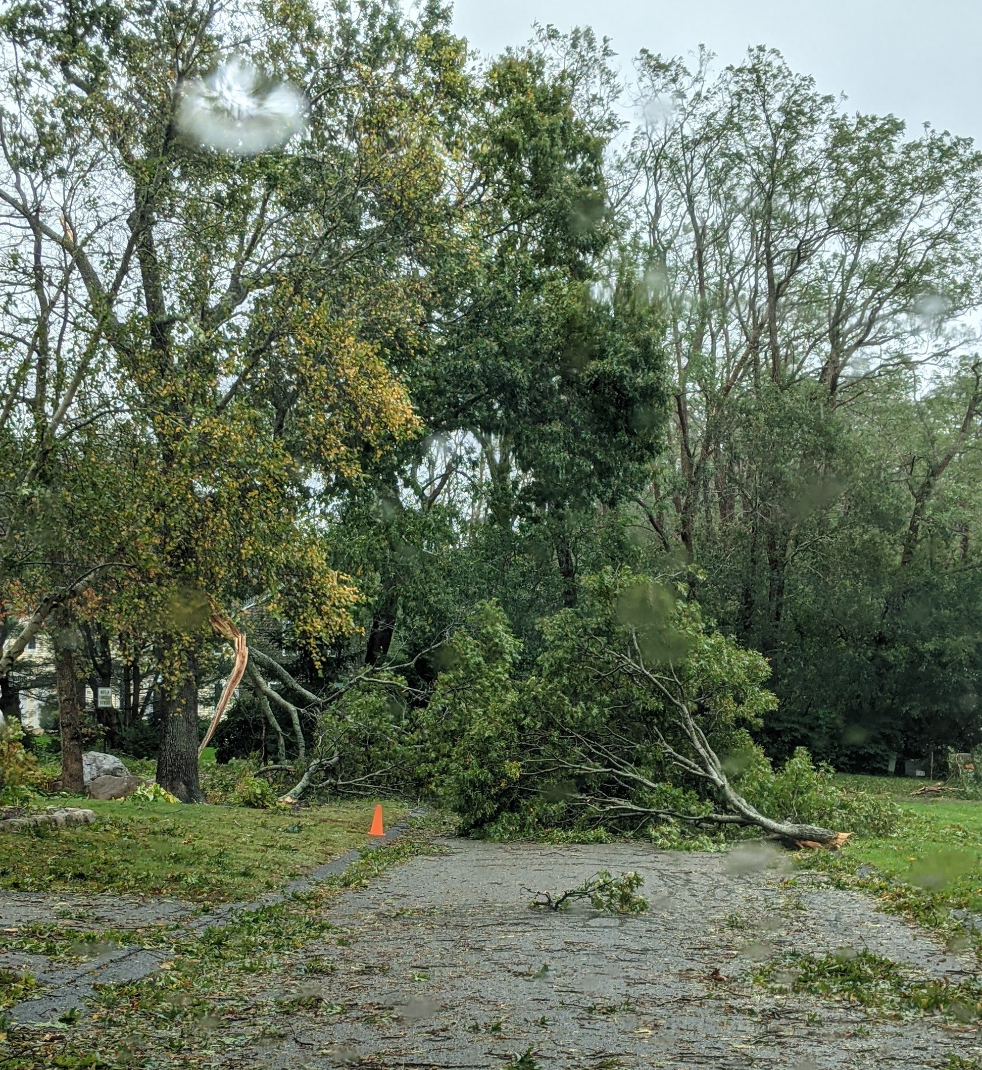
I would bet there's not even a trickle going thru there right now.
-

September 2025 OBS-Discussion centered NYC subforum
nycwinter replied to wdrag's topic in New York City Metro
looking forward to wearing the hoodie again this t-shirt weather last few days is not my style.. -
dr mccoy it's dead jim...
-

September 2025 OBS-Discussion centered NYC subforum
FPizz replied to wdrag's topic in New York City Metro
-
I was on board with that developing like the guidance lol, but I didn’t expect the lid to come off until after the 20th. Just a hostile basin rn.
-
Finally getting around to some final tallies for my location over the course of Meteorological Summer. Total Rainfall (JJA): 13.18" Average High (JJA): 84.2F Average Low (JJA): 68.5F Average Temp (JJA): 75.0F Most Rain Daily: 7/9 - 1.80" Average temp of 75F puts this right near seasonal average, but a touch lower than normal (75.4-76F)
-
Much warmer and more humid today. Currently 76.4/65.6 at 1:45 pm, 10 degrees warmer than yesterday at this time. Partly cloudy with SW breezes 10-15 mph.
-
Not after Lava and Pope are done watering their grass
-
Woo! Thanks Millville, that is the kind of info I was hoping to get - especially from a pro! Much appreciated. ETA- yep - that looks ideal. Went ahead and just pulled the trigger.
-
Yeah just like that, poof. Nothing to track in the LR. This season blows
-
Nobody knows, which is what makes forecasting discussions so interesting. For comparison purposes, here are some very quiet periods during climo active dates of other non-El Nino seasons during the current active era: -In 2024, there were 0 TCs during the 19 days 8/21-9/8. -In 2022, there were 0 TCs in August. -In 2016, there were 0 TCs Sep 4-11 and 0 H Sep 3-28. -In 2013, there was no H til 9/11. -In 2001, there was no H til 9/8 ———- Back to 91L: 12Z Euro has no TC from this in the MDR although something forms later in the subtropics. So, the highly unreliable JMA, especially when it’s on its own, is the line holdout of this cycle for a TC in the tropics from this.
-

-
https://x.com/AndyHazelton/status/1963980757417799798