All Activity
- Past hour
-

December 2025 regional war/obs/disco thread
40/70 Benchmark replied to Torch Tiger's topic in New England
I may send Kevin a Christmas card with this image on the front. -

E PA/NJ/DE Winter 2025-26 Obs/Discussion
Duca892 replied to LVblizzard's topic in Philadelphia Region
Holy crap are the models just boring for the next few weeks -
There was fairly steady contraction in the virga hole on the north side of KLWX which is upstream of even northern MoCo/HoCo. The signs were there that it was gonna do the thing.
-
December 2025 regional war/obs/disco thread
40/70 Benchmark replied to Torch Tiger's topic in New England
I was operating from my own conceptualization of how I expected the month to go, but yea....you probably extend it realistically speaking, but I can tell you no one wants to be a mid month with nothing on the ground or imminent. -
.thumb.jpg.ad3a2e31d30aff035044689b311a0540.jpg)
Winter 2025-26 Medium/Long Range Discussion
nvck replied to michsnowfreak's topic in Lakes/Ohio Valley
all-time weenie run for Mid-Michigan on the 6z gfs...

-

December 2025 regional war/obs/disco thread
SouthCoastMA replied to Torch Tiger's topic in New England
The long term trend of "clippers" cutting through NNE and the inability for them to dig south of us getting old fast. And when somethiing does go south of us its usually compressed into the mid atlantic and shredded with no amplication. -

December 2025 regional war/obs/disco thread
NorEastermass128 replied to Torch Tiger's topic in New England
Dec 5th snows in the Mid Atlantic. I remember that was a common occurrence in the early 2000s. -
Your perspective is too slanted...
-
Grass cut to 1" makes it look like 4"
-
That plus we had full sun on bare ground yesterday. A lot of the four-inch soil temperatures on the mesonet sites yesterday were around 40 degrees. This morning, many have cooled off into the mid to upper 30s. The next storm will accumulate more effectively, IMO.
-
Dropped down to -1 here in the Berks over night, currently 23F back in HPN.
-
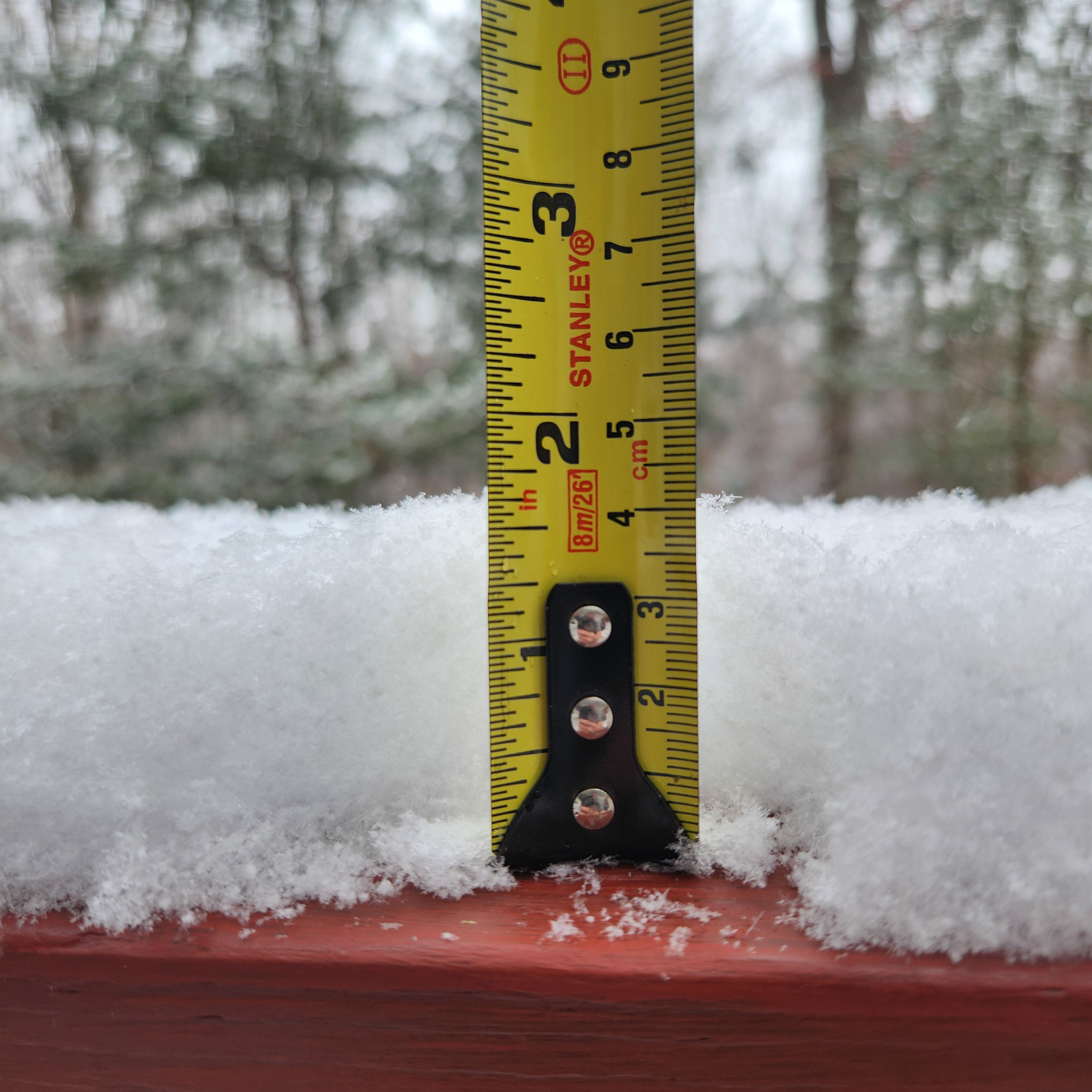
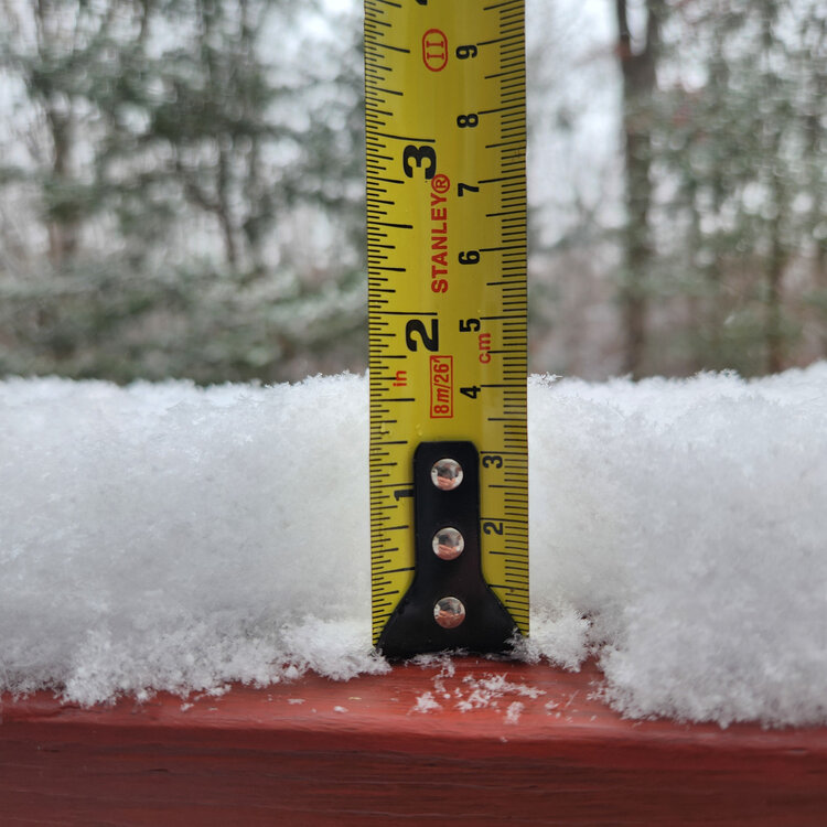
We call that 2.75” in this business
-
1.5” here looks to be tapering off
-
LWX cancelled the WWA for Howard last night before it started and I think they should have let it ride given the overlap with the morning commute…
-
Probably 1.5" here but too lazy to measure so take that for what its worth.
-
Takes that back, snow has picked up and on radar a decent batch to my west to push thru, I'll wait a bit. WAS gonna measre and send in a snow event total to NWS Blacksburg, maybe later. Eyeballing where I've cleared earlier guesstimate 1.5 has fallen since 7 am.
-
Dang. Maybe I did get an inch? Saw an Ellicott City spotter report with 0.6” an hour ago and that’s north of me…
-

December 2025 regional war/obs/disco thread
TauntonBlizzard2013 replied to Torch Tiger's topic in New England
Are we expecting Jan and Feb to be pretty hostile? -
Sitting right at 1.5” at home.
-

December 2025 regional war/obs/disco thread
Ginx snewx replied to Torch Tiger's topic in New England
.png.67dc1fdb6d7e1a3fe13a55c0096fa93a.png)
-
 MANDA changed their profile photo
 -
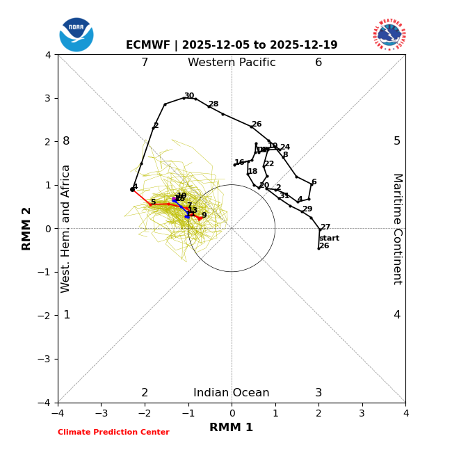
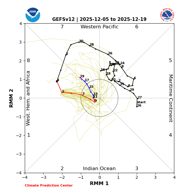
Some degree of moderation in the East after the 16th fits December climatology since 1991. But exactly how much of a relaxation remains to be seen. A 10 to 15 day lag following the current AAM reversal would indicate some degree of moderation by near or after the 20th.
-
Lynchburg, VA 12.05.2025 - 3.4" Total 3.4"
-
Today’s 2 week ensemble MJO forecasts: -12/5 EPS steady as a rock with a 17+ day long phase 8, second (back to 1974-5) only to the 18 days of 1975-6: a cold E US weenie couldn’t place it any better though keep in mind that the MJO, itself, is only one index of many despite it having notable tendencies: 12/5 GEFS: not steady like EPS with only a 5 day phase 8 followed by 3 days of weak phase 1 (which also is often cold in Dec) followed by 5 more days in phase 8 and then 4 days barely in phase 7: Related to the very cold Dec forecasts, NG is up a whopping 6% today, alone!
-
12k Nam is 1-3" up here Monday.
-

E PA/NJ/DE Winter 2025-26 Obs/Discussion
Hurricane Agnes replied to LVblizzard's topic in Philadelphia Region
We are morphing into Colorado, where there is a lot of "spring snow". 'Soon as the daffodils start blooming, in comes the phasing. I ended up bottoming out at 22 but what was more notable and a sign of arctic cold, was the single digit dp of 9 IMBY that I bottomed out to as well. It's currently 24 with dp 12.