All Activity
- Past hour
-
Drought canceled
-
Alpha gal won’t do his laundry or clean his room
-
.61
-
Both days but my oldest daughters is on Sunday . It’s inside at Gampel but you still want it nice . She’s off the books. My other one had two years left there . Moving her home Saturday for summer . Next year she’s in the new apartments where all the shops and restaurants are.
-
Make that EXTREME DROUGHT
-
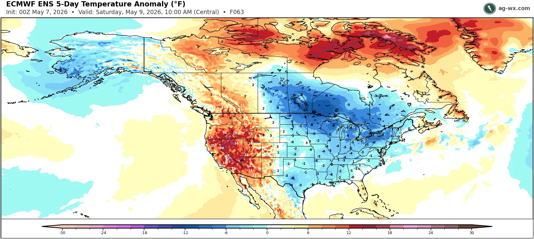
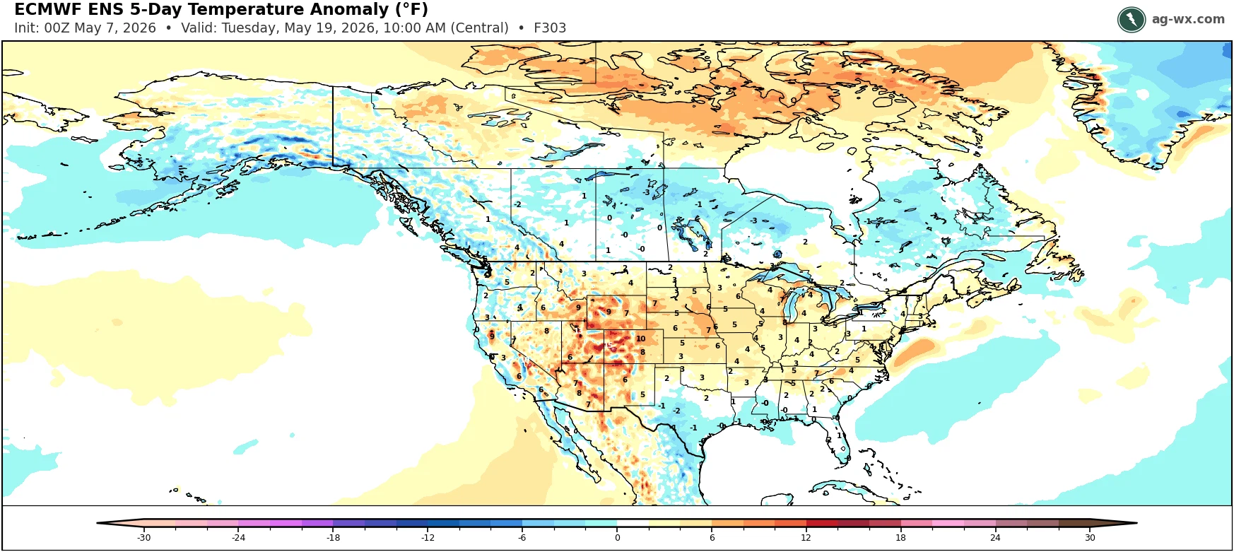
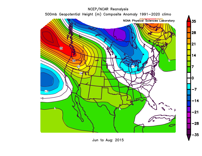
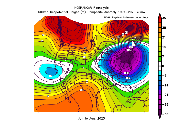
Looks like a gradual warming later in May following this coming cooler period. One thing to watch will be that we have a record +PMM now which is closer to the summer of 2015 El Niño than 2023 which didn’t have the strong +PMM. So it’s possible we get a warmer summer than 2023. But we would want to see how the transition from late May into early June verifies in order to know for sure. Stronger +PMM in summer of 2015 Weaker PMM in 2023 EPS forecast next 15 days


-
Just picked up 3 inches the last hour. So yup, we are flooded. Still raining at 3 inches per hour.
-
As expected temps overachieved. Hit 31.
-
0.05 total and less than a tenth combined with last weeks "rain event." I'm about ready to just give up on trying to get a new yard going. I don't expect any real rain until probably the fall.
-
Beta gal?
-

2026-2027 Strong/Super El Nino
bluewave replied to Stormchaserchuck1's topic in Weather Forecasting and Discussion
There was a recent paper released on this topic calling it the PCC. But we will probably need the data for this next event included to help develop the new idea. Remember, the climate models missed the sudden rise in temperatures in the spring of 2023. So it’s possible that the current climate modeling technology is developing too slowly to capture the faster changes that have been occurring. https://www.nature.com/articles/s41467-024-52731-6 Much recent work focused on whether equatorial Pacific cooling over past decades is driven by anthropogenic effects or arises from internally-generated climate variability, like the IPO. A definitive anthropogenic link to the recent trends would allow us to reliably predict a cooler tropical Pacific. As the tropical Pacific is known to be a climatic pacemaker, for (at least) the near-future this would mitigate global warming via ocean heat uptake and low-level cloud feedbacks. Instead, if the cyclic IPO dominates the recent cooling, we may expect a strong warming when it reverses. In support of the first possibility, we have identified an emerging climate change signal in the tropical Pacific across different observational datasets and we call it the PCC. The PCC has distinctive ocean-atmosphere dynamics that differ from those associated with the IPO. We further demonstrate that the recent trends during the satellite era, which have been the focus of significant attention, result from a combination of IPO and PCC. The emerging PCC SST trend pattern features a narrow band of cooling in the eastern equatorial Pacific and warming elsewhere. This SST change is linked to thermocline shoaling/SSH decreases in the central-to-eastern Pacific and dipole-like changes in zonal surface wind stress. In contrast, the recurrent IPO-driven SST trend pattern is characterized by a meridionally broader cooling in the eastern Pacific, zonal dipole-like thermocline/SSH changes and an overall strengthening of tropical Pacific zonal wind stress. We have shown that these distinct ocean circulation changes are a response to different wind stress patterns. These oceanic responses account for surface cooling in the eastern Pacific, with the thermocline shoaling playing a dominant role in the PCC cooling and enhanced zonal advective cooling mainly driving the IPO-related cooling. While basic geophysical fluid dynamics proved sufficient to attribute the observed oceanic changes to surface wind stress, we have not addressed the origins of the wind stress patterns associated with the PCC and the IPO. New research is needed to elucidate the wind changes, but our leading hypothesis is as follows. In response to GHG forcings39,40 temperature change in the upper troposphere are stronger than at the surface (Fig. S4), increasing atmospheric static stability. Consequently, the initial SST and surface wind response to rising GHGs might not be amplified as efficiently via Bjerknes feedback as is that for the internal modes on interannual to decadal timescales. Given the differences in thermocline and ocean current patterns associated with the PCC and the IPO, the coupled feedbacks related to ocean dynamics are also expected to differ, potentially contributing to distinct climate pattern formations for decadal variability and climate change. Additionally, climate variations outside of the tropical Pacific may influence the tropical Pacific trade winds26,27,41,42,43,44. Further, it has been argued that pronounced decadal-to-multidecadal SST variability in the Atlantic Ocean is also dominated by the response to the same external forcing that the tropical Pacific encounters45. Perhaps the co-occurrence of these long-term trends in different regions is not simply a direct response to rising GHGs but is influenced by inter-basin interactions. More work is needed to disentangle causal relationships among the long-term changes in different basins46,47. Throughout this paper we have taken for granted the widespread assumption that the IPO is an internal mode of the climate system. However, while we worked to distinguish between the recurrent IPO-related decadal variability and the emerging PCC signal, we are open to the possibility that these two may have become coupled together by anthropogenic forcing. They have much in common: shoaling of the thermocline in the east, enhanced upwelling somewhere in the central-to-eastern equatorial Pacific and an enhanced zonal SST gradient across the equatorial Pacific. It seems reasonable to postulate that if the response to radiative forcing is the emerging PCC pattern seen here, then it could initiate coupled ocean-atmosphere feedbacks that favor a negative IPO state that also has an enhanced SST gradient24. This might explain why the most recent IPO swing has been extreme and robust (Fig. S1b). If so, this suggests that in nature forcing is projecting onto natural modes of variability, while it is not clear whether climate models can reproduce this behavior. A new perspective on how internal variability interacts with the climate change signal will be needed in future studies. -

Winter 25-26 (All Snowfall Maps & Season Total)
The 4 Seasons replied to The 4 Seasons's topic in New England
Yeah i just added the 0.5 you gave me on March 3rd to the 79.6 you had on March 2nd. Same with Tolland. I was hoping the map would change significantly after the beginning of March but i guess not...not this year, another dead March. -

Central PA Spring 2026 Discussion/Obs Thread
Itstrainingtime replied to Voyager's topic in Upstate New York/Pennsylvania
Picked up another quarter inch overnight! -
Almost 0.30" total for yesterday and last night.
-

Central PA Spring 2026 Discussion/Obs Thread
pawatch replied to Voyager's topic in Upstate New York/Pennsylvania
41 degrees this morning. Picked up .26” of rain yesterday Just shut my coal stove down Tuesday morning after a 3 day run. -
The heaviest stayed south of yall..we've gotten hit really good but just north has been putrid.
-
This has been a huge bust IMBY. Before this last round I had only had 0.31 inch of rainfall storm total. That’s a far cry from the inch-plus in the forecast. Ouch.
-

2026-2027 Strong/Super El Nino
Stormchaserchuck1 replied to Stormchaserchuck1's topic in Weather Forecasting and Discussion
For 1 month. December, Feb, March, and April were all -PNA You believe global warming is a main driver of dominant patterns? I think we have more of a background -ENSO/-PDO state so it may not be like some of the classic Strong Nino's but I don't see the relevance in "new global temperature 3 years apart" aside from general warming. -

Central PA Spring 2026 Discussion/Obs Thread
Blizzard of 93 replied to Voyager's topic in Upstate New York/Pennsylvania
Next rain concern is Saturday. There is a softball tournament scheduled in northern Perry County. Anyone have any thoughts on the timing & amount of rain at this time? -
It's my biggest fear. I'll take anything other than alpha gal
-
0.20” overnight 0.48” total
-
Central PA Spring 2026 Discussion/Obs Thread
Blizzard of 93 replied to Voyager's topic in Upstate New York/Pennsylvania
.29 of rain yesterday in Marysville. The rain yesterday ended early enough for the softball field to drain. They got the game in & my daughter’s team played well and got the win. -
Cold n wet this morning. Looks sun will be breaking out soonish though.
-
Put every chemical known to man down and kill em all.
-
Perfect!