All Activity
- Past hour
-
91/74 at 10am
-
12z HRRR is quite a bit wetter down there.
-

2025-2026 ENSO
CP_WinterStorm replied to 40/70 Benchmark's topic in Weather Forecasting and Discussion
I've noted that the JAMSTEC actually does a decent job at this distance with the overall configuration of the SSTA in the Pacific during the DJF period. That said, the current forecast makes a half assed effort at a PDO regime change during the upcoming DJF period: Far from a solid +PDO but hopefully the severely negative period we're headed into, again, will be short lived.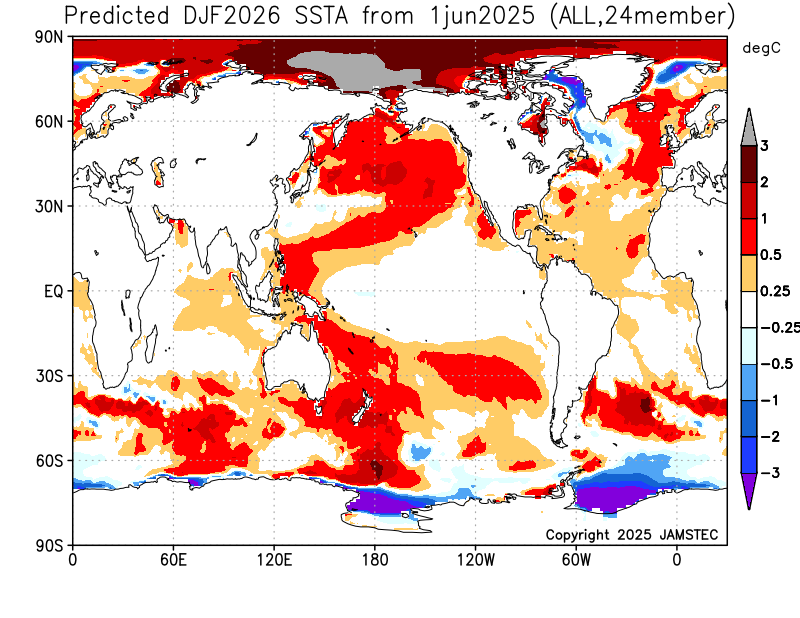
-
the lava from yesterday has already remelted and its not even 10 AM yet
-

-
I'm running about the same here in salisbury when compared to yesterday .. although my low was 3 degrees higher at 74.5
-
I’ve been coaching everyday this week and so far this morning is by far the worst feeling. Not looking forward to the meet tonight.
-
So so many big time heat waves end with a bang its unusual when they dont.
-
Thank you. *Blushing*
-
 We're having it now. The longevity, the temperatures, the heat index, the mins. This is by far the hottest June stretch on record in the northeast
 -
Lots of tree damage locally from the storms last night. Must have been a downburst. Power is out in many places in Chagrin, South Russell and Bainbridge. Closing in on 9" of rain for the month... current total is 8.67".
-
 Islip has reached 90F (32.2C) for the 4th consecutive day. That ties the record for the longest June heatwave. That record was set during June 24-27, 2003. The current heatwave is the earliest 4-day one on record.
 -
Wasn’t Ian’s target for 100F days to hit 90 by 10am??
-
MDT shattered the record high min temp by an impressive 3 degrees. Low was 78.
-
It's romantic to think of big heat ending with an exit big bang ... but, she seldom shows up. The reason for that is because as is typically the case, the front that demarcates the surface end of the heat wave, parallels the flow - typically still having heat wave CIN layer cap. This mollifies instability while also doesn't provide triggers. The result is that it just sort of goes away. It's progress in displacing the heat is in lockstep with the speed of the height decay aloft. As the ridge recedes, the front is repositioning accordingly. You can see that happening here. WSW-ENE oriented front side-winding slowly south, as the ridge is deflating - booorinnng We just find our selves in a different world tomorrow with severe drizzle to show for the giant change.
-
 Seeing some upper 90s in N Massapequa area.
 -
87.4
-
The seasonal oscillation....you can set your watch by warm piece of shitness during the cold season holidays.
-
Sell. Tomorrow is dry and 70’s.
-

E PA/NJ/DE Summer 2025 Obs/Discussion
JTA66 replied to Hurricane Agnes's topic in Philadelphia Region
Looks like I also touched 100F yesterday. 85F/DP 74F shortly after 9am -
that NW/SE stretched ridge even showing its ugly head in the summer is the real suprising thing for me considering how many times that bit our ass last winter... To me, I think it has something to do with the increased zonal flow aloff, though I am an amature compared to you and others here
-
Yep, 4 day heat wave. Still a 32010kt wind so a few more ticks maybe before winds go light onshore.
-
It was 90 by 9 at Logan fwiw-


