All Activity
- Past hour
-
Yeah, forecast soundings along the warm front certainly support at least transient supercell structures. The question is where the warm front will reside, as there isn't good model agreement. If there is a weak consensus, it's for the warm front to set up just south of DC. Saturday could be a hail threat throughout the area, as very cold temperatures aloft will be in place, and the secondary front looks to move through at a favorable time of day.
- 777 replies
-
- 1
-

-
- severe
- thunderstorms
- (and 2 more)
-
Maybe, but in fairness people evacuate (or not) based on complex factors and circumstances.
-
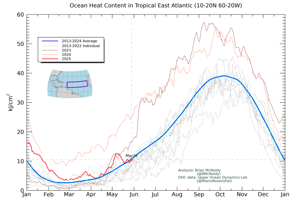
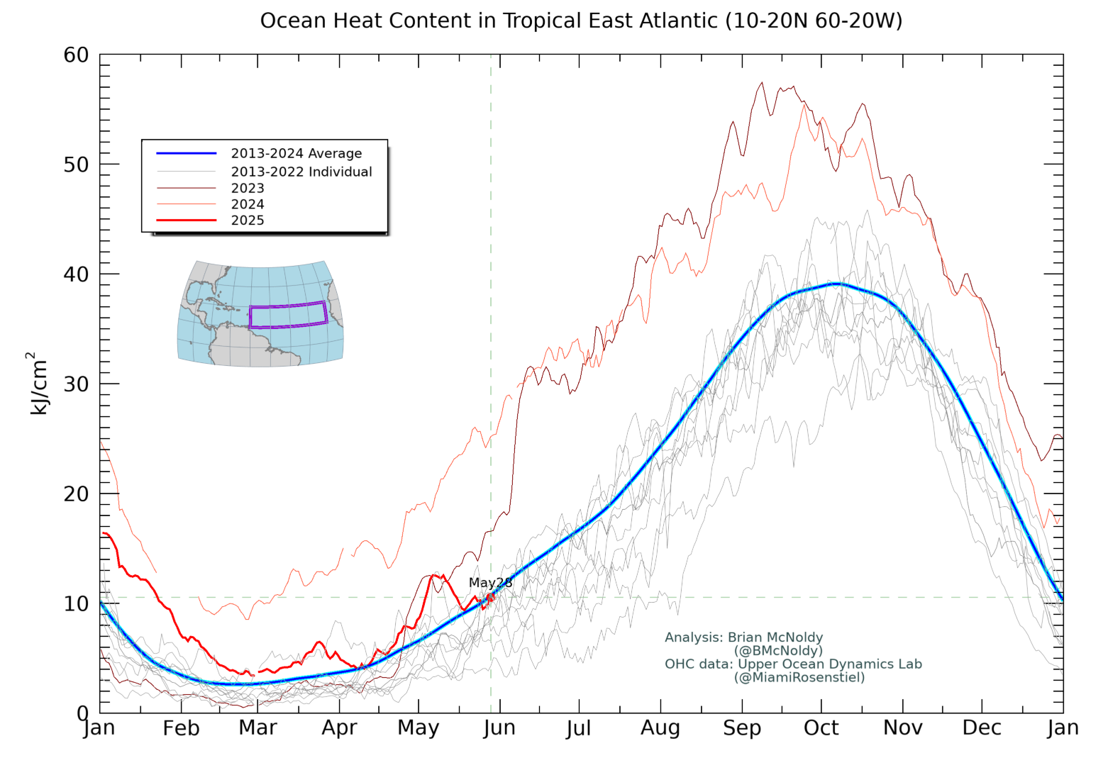
As of May 28th, OHC is near the 2013-24 average. That’s still quite warm, but it’s not nearly as warm as 2024 and is even a bit cooler than 2023. I’ll be interested to see where it is in a couple of weeks:
-
Every time it’s halfway decent out, our course seems packed. You can never make up full for bad days but it’s been good to be busy when you can.
-
In my house, any husband who didn't call yesterday like he promised would be sent packing. I don't mess around with not having air conditioning.
-
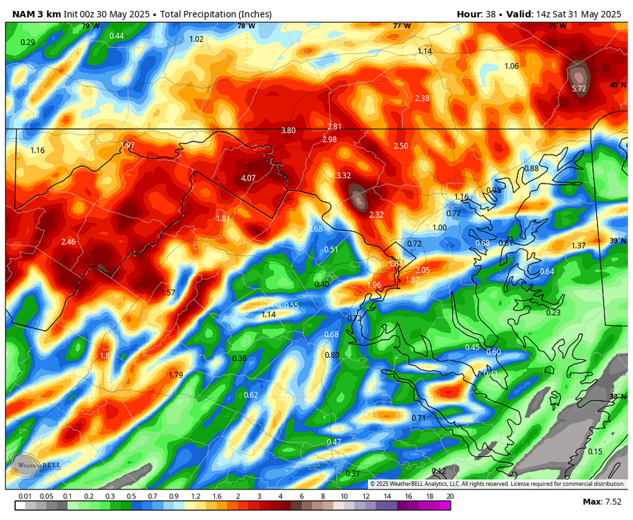
00z NAM Nest looks interesting... granted the storms weaken by the time they get up here... but those look nasty in the SW parts of the LWX CWA
-
I leav for a week in PEI next Friday. Probably not going to get to install until I get back.
-
I can’t stop looking at it, but this glacial landslide is nuts. The fact everyone willingly evacuated swiftly days prior is some strong trust in science.


-
Okay, that was an impressive rain. 2.82 inches in about 90 minutes. Started to rush so hard it was overtopping the big yard drain I put in last fall so I pulled the grate and created a 3.5 square foot hole to a 12 inch culvert. That did it. . Cool whirlpool effect that my daughter enjoyed. .
-
- Today
-
WB 0Z 3K NAM continues to shift NW....
-
Looks like there could be enough surface wildfire smoke for some visibility impacts/smell on Saturday. Either way, should be a rather hazy/milky sky.
-

2025 Lawns & Gardens Thread. Making Lawns Great Again
backedgeapproaching replied to Damage In Tolland's topic in New England
I think the problem with Vinegar is that its mostly a surface kill. It will most likely go brown pretty quick, but I don't think it gets to the roots for a total kill, so it will just come back. Not just poison ivy, but any thing you are trying to get rid of. I am all ears too for a natural solution that actually works and kills down to the roots. -
.98 in Marysville from the system yesterday.
-
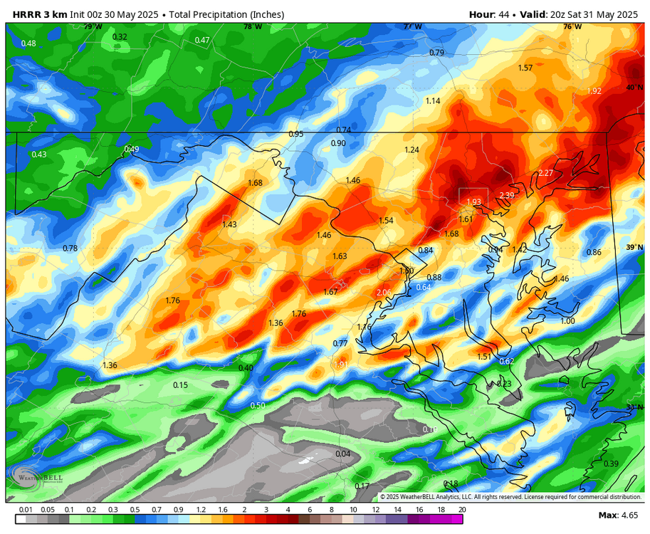
WB 0Z HRRR...most of the rain falls later afternoon/overnight Friday.
-
Interesting that it doesn't include the highlands. I'm over 9 inches for the month and streams are still quite swollen. Must think our QPF won't amount to a whole lot (altho @MillvilleWx and his crew still include us in the slight risk for excessive rainfall).
-

E PA/NJ/DE Spring 2025 Obs/Discussion
Nodriveslow replied to PhiEaglesfan712's topic in Philadelphia Region
Lock it in! -
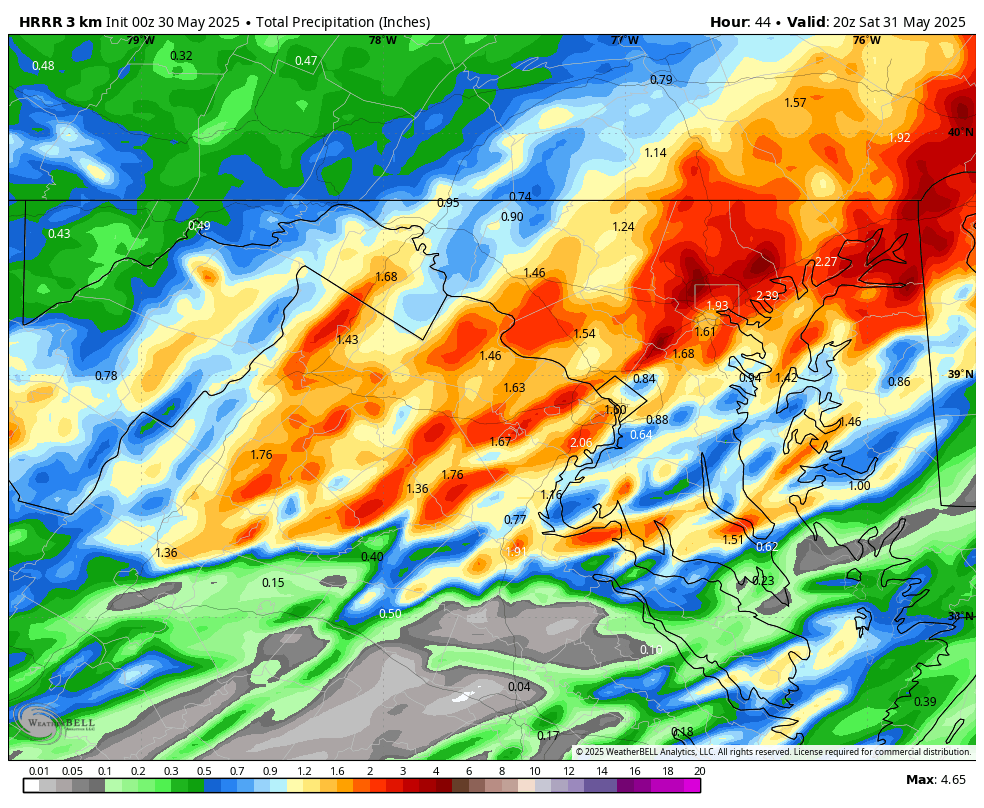
Details on the Flood Watch flagged above: District of Columbia-Frederick MD-Carroll-Northern Baltimore- Cecil-Southern Baltimore-Prince Georges-Anne Arundel-Charles-St. Marys-Calvert-Northwest Montgomery-Central and Southeast Montgomery-Northwest Howard-Central and Southeast Howard- Northwest Harford-Southeast Harford-Nelson-Albemarle-Greene- Madison-Rappahannock-Orange-Culpeper-Fairfax-Arlington/Falls Church/Alexandria-Stafford-Spotsylvania-King George-Northern Fauquier-Southern Fauquier-Western Loudoun-Eastern Loudoun- Northwest Prince William-Central and Southeast Prince William/Manassas/Manassas Park- 831 PM EDT Thu May 29 2025 ...FLOOD WATCH IN EFFECT FROM FRIDAY EVENING THROUGH LATE FRIDAY NIGHT... * WHAT...Flash flooding caused by excessive rainfall is possible. * WHERE...District of Columbia, Maryland, including the following areas, Anne Arundel, Calvert, Carroll, Cecil, Central and Southeast Howard, Central and Southeast Montgomery, Charles, Frederick MD, Northern Baltimore, Northwest Harford, Northwest Howard, Northwest Montgomery, Prince Georges, Southeast Harford, Southern Baltimore and St. Marys, and Virginia, including the following areas, Albemarle, Arlington/Falls Church/Alexandria, Central and Southeast Prince William/Manassas/Manassas Park, Culpeper, Eastern Loudoun, Fairfax, Greene, King George, Madison, Nelson, Northern Fauquier, Northwest Prince William, Orange, Rappahannock, Southern Fauquier, Spotsylvania, Stafford and Western Loudoun. * WHEN...From Friday evening through late Friday night. * IMPACTS...Excessive runoff may result in flooding of rivers, creeks, streams, and other low-lying and flood-prone locations. Flooding may occur in poor drainage and urban areas. * ADDITIONAL DETAILS... - As a wavy slow moving frontal system tracks across the area, multiple rounds of showers and thunderstorms are possible. While initially posing a severe weather threat, a shift to a slow moving complex of moderate to heavy rain unfolds into the evening and night. Storm totals could reach 2 to 3 inches, locally nearing 4 inches in spots.
-
Couldn’t even happen in Dante’s Peak…barely but not really
-
Good call by me. Will suck for many.
-
Quote the posts or didn't happen.
-
The hyperbole is creative and yes, it can run amok to the point no one knows what was/is base-line. lol
-
I'm just here to share and look at the current models... it's like a story line or plot. You just try to keep up with it. It can be entertaining. There's also a lot of hyperbole, which can be fun and hard to detect sometimes. A wrapped up nor'easter or a sunny summer day become the goalposts, when we all know its usually a compromise between solutions. We need an AMWX ensemble of user thoughts to model the weather. Probably would be pretty good, ha.
-
Yup sucks
-
It’s all in fun until the wolf attacks


.thumb.JPG.418e8a9a2902ae687ec35ff4bc0e038e.JPG)


