All Activity
- Past hour
-
Here we go again …

-
Such a fantastic gif lol
-
Welcome back! Yeah, I think last good chance here for a bit as we look like we’re gonna warm up mid month. Have to get it while you can. I’ll take another inch and not complain. Maybe Raleigh can squeeze two or three they deserve it. .
-
 NEFE?
NEFE? -
I was thinking this morning that ASOS stations were more likely to not go over 32 since presumably they are better shielded than the typical PWS. We got to 34 here.
-
I’m still watching that little LP in the upstate… GFS latching onto Lee enhancement
-

Is we back? February discussion thread
RUNNAWAYICEBERG replied to mahk_webstah's topic in New England
Post skynet same time now… -

February 2026 OBS & Discussion
donsutherland1 replied to Stormlover74's topic in New York City Metro
For NYC, only 2002 and 2020 had no measurable snowfall for February 1-March 31. -
41.5 here, honestly shocked we’ve held onto snow cover. Guess the permafrost is helping us
-
I took a break today from the forum and come back to a thread pages deep about this storm. Ain’t mad at it! Let’s eat again before the pattern relaxes!
-
Topped out at 33F.
-
Wait for it, still early yet
-

Is we back? February discussion thread
Damage In Tolland replied to mahk_webstah's topic in New England
Runaway doesn’t follow -

February 2026 Medium/ Long Range Discussion: Buckle Up!
psuhoffman replied to Weather Will's topic in Mid Atlantic
we had a blizzard what would have been presidents weekend 1958 but the holiday was still called Washington’s Birthday then. -

Richmond Metro/Hampton Roads Area Discussion
Ephesians2 replied to RIC Airport's topic in Mid Atlantic
Yeah the follow up wave is our only shot at our latitude This is the type of thing that can trend north and juice up in the short-medium range, though, imo. Might get a 1-3" deal out of it. -

Richmond Metro/Hampton Roads Area Discussion
ORFDawg2013 replied to RIC Airport's topic in Mid Atlantic
18z Euro from the SE Forum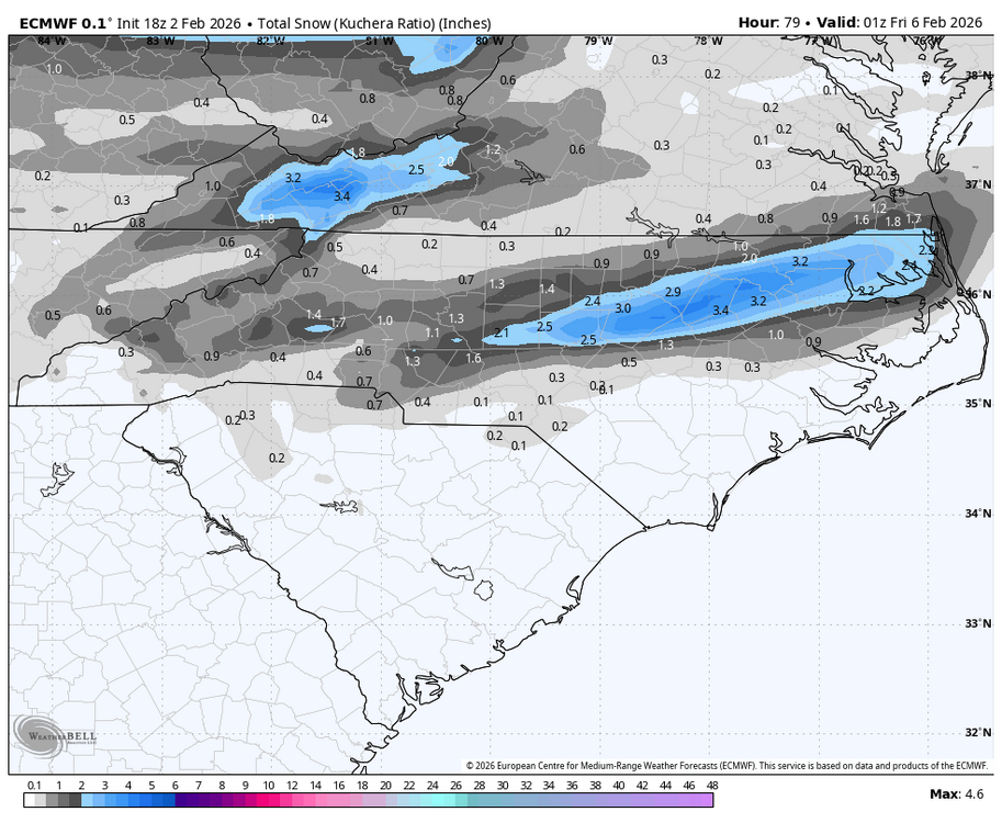
-

February 2026 Medium/ Long Range Discussion: Buckle Up!
Terpeast replied to Weather Will's topic in Mid Atlantic
Bad news, aigfs is an op model so little confidence in its blizzard scenario. The GOOD news is ensembles (including euro and ai euro) do have some support for that scenario by undercutting a s/w under HL blocking. The ens means is smoothed out, but if you can “read between the lines” you can see a sharper trough or ULL swing across the mid-south towards us from feb 13-16. -
Both skynet models have been more bullish for keeping snow chances (even with moderated temps) than the regular model suites in the second week of February. We’ll see as we get closer if that’s more correct. They have been performing pretty well imho overall. They never got very bullish on the 1/31-2/1 threat (correctly so), stayed more bullish than OPs on both the 1/18-19 and 1/25 threats (also correctly). Still in clown range for now.
-
High 42, low 11. Didn't seem like much melting going on, just evaporating. Crazy.
- Yesterday
-

February 2026 Medium/ Long Range Discussion: Buckle Up!
snowfan replied to Weather Will's topic in Mid Atlantic
That storm would be an I-81 special -
It;s like Blind Ralphy in Christmas Story "What hath brought you to this lowly place?"
-
Richmond Metro/Hampton Roads Area Discussion
ORFDawg2013 replied to RIC Airport's topic in Mid Atlantic
18z 3K NAM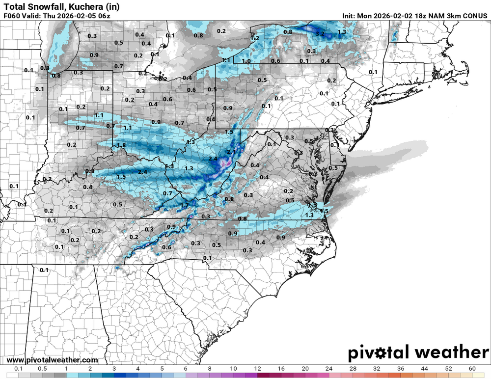
-

February 2026 Medium/ Long Range Discussion: Buckle Up!
Jake Wx replied to Weather Will's topic in Mid Atlantic
good god
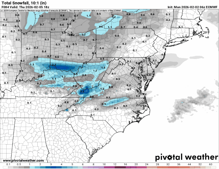
-
18z Euro...trended the last 3 runs
-

Jan 30th-February 1st 2026 Arctic Blast/ULL Snow OBS Thread.
John1122 replied to John1122's topic in Tennessee Valley
My area is so often off, as is Daniel Boone's that an artificial snow hole shows up on the GFS and NAM over us for almost every storm. This is something like 8 years in a row here with about 50 percent or less than actual accumulation recorded.


