All Activity
- Past hour
-

Central PA Winter 25/26 Discussion and Obs
Mount Joy Snowman replied to MAG5035's topic in Upstate New York/Pennsylvania
Feels like a good time to remind everyone of the following, all of which is taken from MU's exactly 100 years of snowfall record-keeping. MU only averages a 12"+ snowfall about once every three years and only averages a little over two events per year with >4". They average ~9.5 measurable snowfalls a year at an average accumulation of 2.86", for a yearly average ~27". Over 75% of the accumulated snowfall comes from events <4". 32% of the snow falls in Feb, 30% in Jan, 17% Dec, 16% Mar, 3% Nov, and 1% in April (yes I'm aware these add up to 99 and not 100 ha). Leanest decade was the 50's with an average annual snowfall of only 21.6". Current decade is averaging only 14.8" but that is coming on the heels of one of our snowiest from 2010-2019 with an average of 35.5". Snowiest decade was the 60s with an annual average of 36.2". -
When I moved from the upstate of SC 10 years ago to the western Piedmont of NC, I thought for sure I’d see more snow. Who knew that if I had taken the job on the coast, I would be in the best spot in the Carolina’s outside the mountains for snow.
-
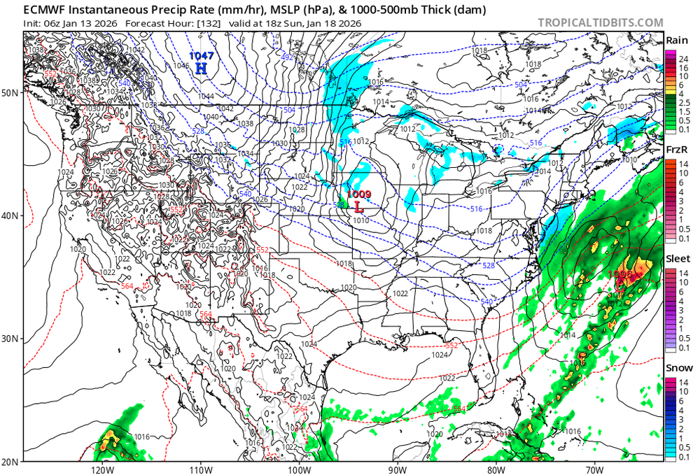
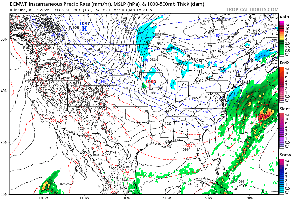
Could be two storms in that one period. First cutter through OHV, and then a second one to the south of us. You can see the two precip maxes across WV/PA and across VA/delmarva.
-
-
this look close definitely something to watch in the next few runs. chances are low but models suck
-

2025-2026 ENSO
40/70 Benchmark replied to 40/70 Benchmark's topic in Weather Forecasting and Discussion
What a silly post. Do you understand why the ONI is measured on a tri-monthly basis?? -
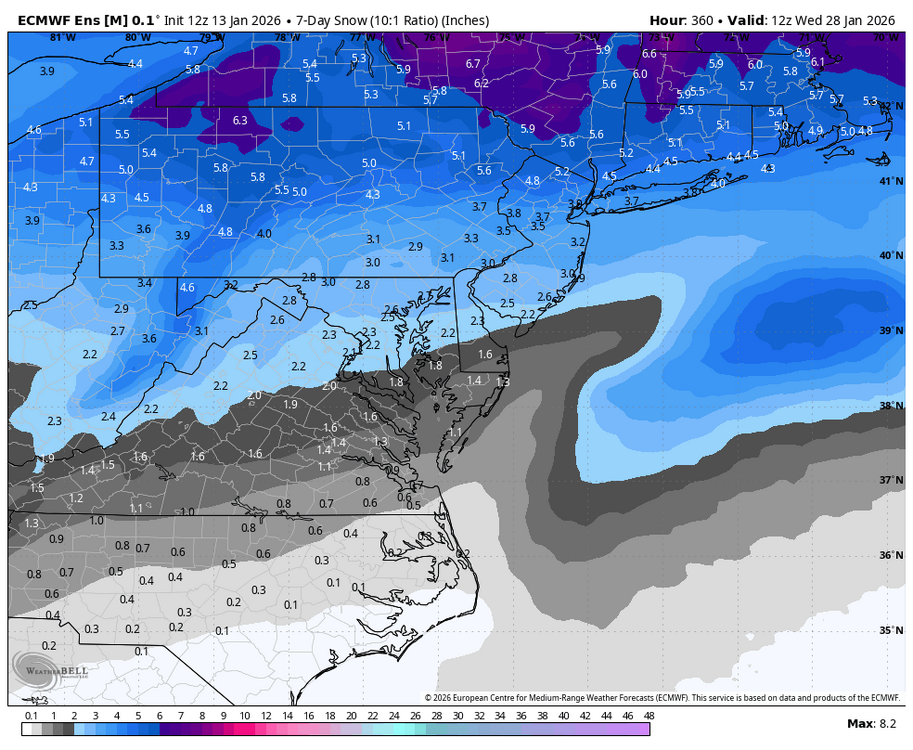
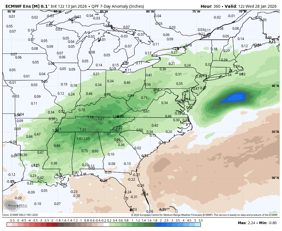
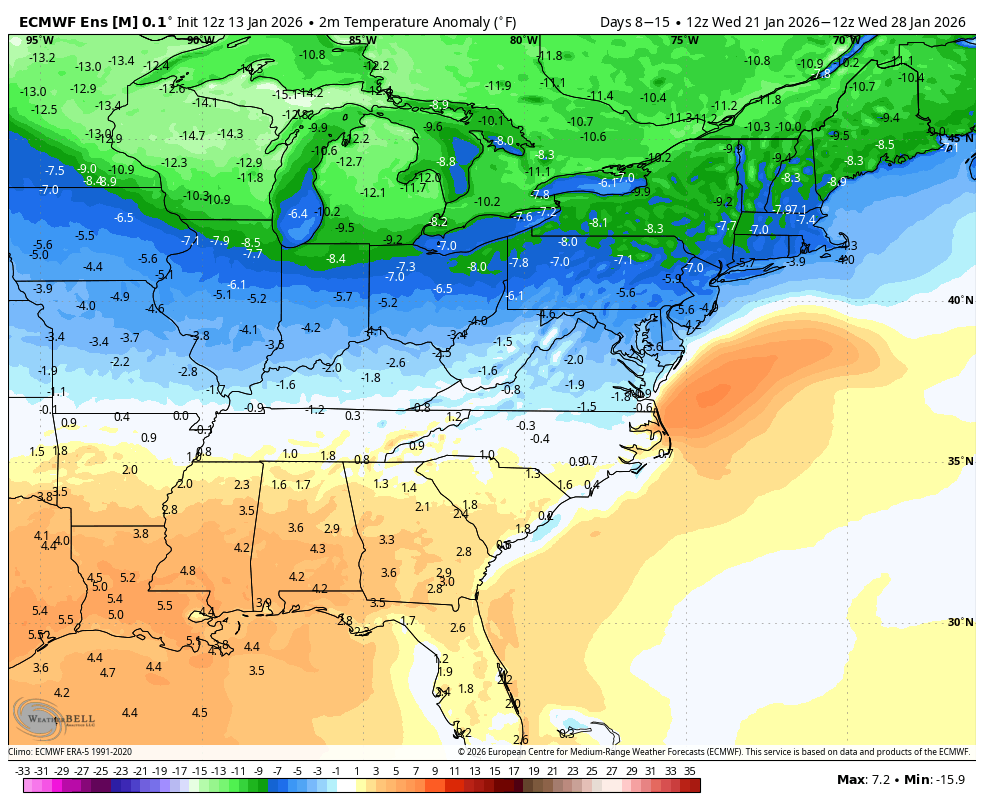
WB 12Z EPS 7 day temp and precip. anomalies and snow 21-28th.


-
2025-2026 ENSO
40/70 Benchmark replied to 40/70 Benchmark's topic in Weather Forecasting and Discussion
What has he been wrong about? It's been colder than just about everyone thought....he kept harping on dry winter and that is precisely what we've seen. -
for what? Dry and cold?
-
Looks like the HRRR has rain ending as some snow in central NC for Thursday.
-
This is me this winter. 32" on the year with >1" snowcover for 42 of the last 45 days and yet the high water mark for OTG is 5.5". The 1.5" that is OTG now is a block of ice. You can stand on it and it does not give. I went to core it yesterday before I headed to DC for the week and it broke the plastic gauge I use to assess water content.
-
Not a huge fan of the choice though I get it. He's clearly a fantastic coach that has turned a 4-13 roster into a 9-8 team for the past 4 years... but the team needs a good tank. Kinda hope the Giants scoop him right up.
-

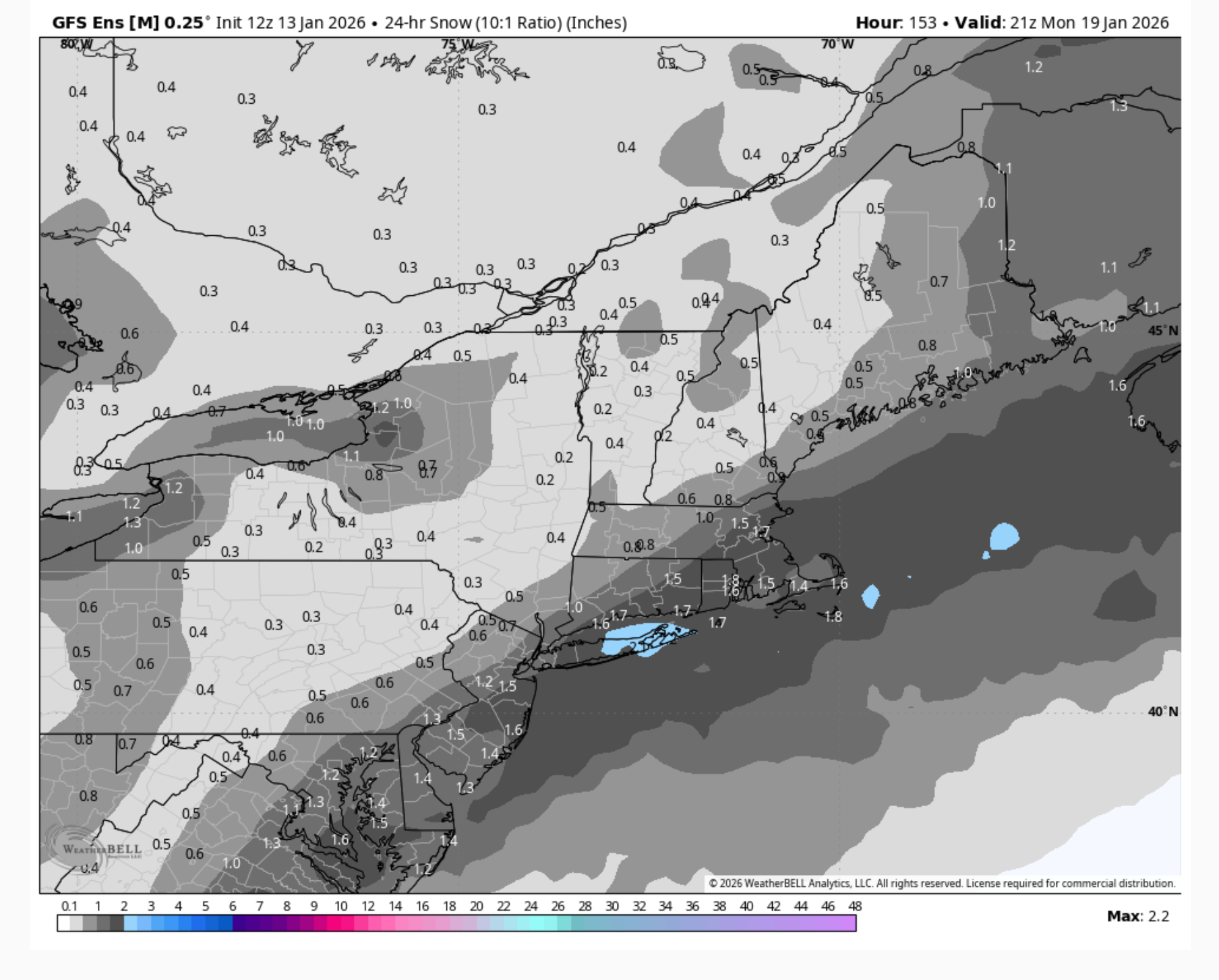
January 2026 regional war/obs/disco thread
The 4 Seasons replied to Baroclinic Zone's topic in New England
Yeah about 7/30 have a moderate/strong hit, so its showing up on the mean like this (24-hr)
-
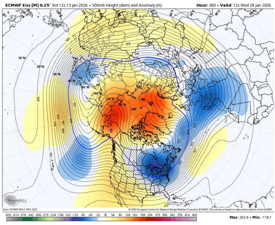
Now THAT is a really good pattern.

-

January 2026 regional war/obs/disco thread
ORH_wxman replied to Baroclinic Zone's topic in New England
Not to mention we’ve had several systems that were initially amped get crunched SE and whiffs or something less impressive…even including the “cutter” this past weekend which ended up a sheared out piece of trash with lots of CAD. -
@Carvers Gap the maps look really good. Just need a well timed system to drop from Wyoming to Louisiana. I don't have access to individuals. Is the Euro throwing anything showing this type potential or are they mostly showing a gradient pattern in the LR?
-
We definitely believe you. Just add in a few more smiley faces to really convince the rest.
-
sure jan.
-
Tick tock….
-
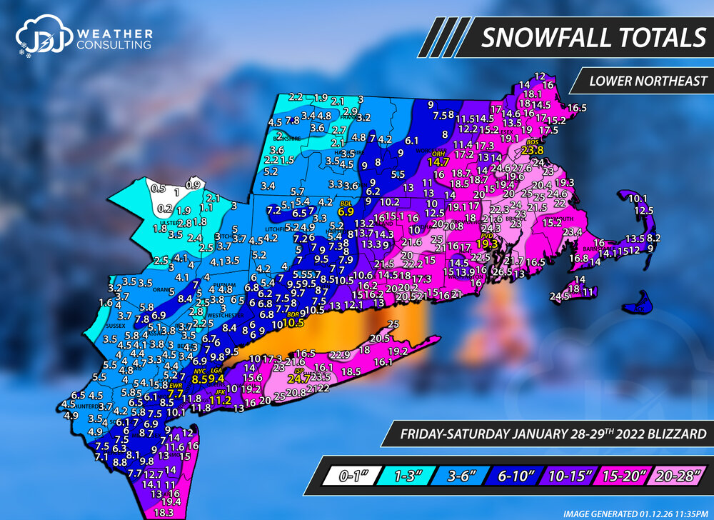
That is 10" in W. Thompson. That was the storm that had massive subsidence outside of those main mega bands and caused a serious snowfall gradient around them. Reports in the surrounding areas were similar with 12.5" in putnam and 10" in hampton. If it was just one rogue report i might consider tossing it but there were many that fell off sharply once you got out of that main banding. Also don't forget this was the storm where i had a very long conversation with @JC-CT about his 9" report in Columbia despite all the surrounding reports being in the 13-22" range. I believe him and thats why there is a hole over Columbia. Same thing with @metagraphica14.5" report in Salem. It can be very hard to discern whats legitimate and what's not especially in a storm like this thats long duration, lot of wind, and subsidence outside of banding. But i definitely think those reports are legit considering everything surrounding it is in the 10-13" range around Thompson. Here's the revised updated maps i just finished, ct, sne, tri-state are also updated https://www.jdjweatherconsulting.com/jan-28-29-2022
-
Mike Tomlin is stepping down. Wow.
-
“30+ days in MJO phase 8 in December”. One of the best doozy’s of all time from you. Stick to arresting perps in the Bronx
-
How many times are you going to be wrong this winter ? Jeez man give it a rest.
-
pretty nice timeseries from the campus wx station today, sw winds really ripping through campus, and we're a few degrees above modeled for the afternoon.
Scaled(32_).thumb.jpeg.a0a4f602971efdf65bd54cdd55911a67.jpeg)
-

Winter 2025-26 Medium/Long Range Discussion
A-L-E-K replied to michsnowfreak's topic in Lakes/Ohio Valley


.thumb.jpg.ad3a2e31d30aff035044689b311a0540.jpg)