All Activity
- Past hour
-
lol let's go GGEM/RGEM for Monday!
-
Awful loss. But they've had a bunch of those already. Just no sign of them turning it around. I thought that 10 wins out of 14 games (or whatever that stretch was a couple weeks ago) was it...but nope.
-
I would not want to visit the Middle East. It is way too hot there. I have heard of their *LEGENDARY* heat indices over there. Make Texas in Summer look like a cool autumnal breeze lol.
-
MOAR storms are forming directly over Buda this morning at 12.47am!!! Some of the radar elements are deep red. This rain is torrential at times! We got three quarters of an inch in about 10 minutes! We are now up to 28.1 inches on the year! This is unbelievable! I am gonna have to start building Jebman's Ark!
-
We will see if Monday produces.
- Today
-
Well, I think this L from the Orioles will be the proverbial nail in the coffin for the season. I don't see how they come back from this one. They might get swept in back-to-back series and fall 9 games under .500 after this one with the Dodgers. They needed to win tonight and had a chance and blew it.
-

2026-2027 Super El Nino
Stormchaserchuck1 replied to Stormchaserchuck1's topic in Weather Forecasting and Discussion
Strongest on record, since the mid 1800s. -

2026-2027 Super El Nino
PhiEaglesfan712 replied to Stormchaserchuck1's topic in Weather Forecasting and Discussion
Was 09-10 a strong -NAO? -
2026-2027 Super El Nino
Stormchaserchuck1 replied to Stormchaserchuck1's topic in Weather Forecasting and Discussion
65-66 would have been well above normal if it wasn't for strong -NAO. Not saying we can't have -NAO this Winter, it's more random vs ENSO -
2026-2027 Super El Nino
Stormchaserchuck1 replied to Stormchaserchuck1's topic in Weather Forecasting and Discussion
Best I could do is 20c isotherm depth, but here's most recent day vs that day in 1997 Depth average temp Edit: I found 1997's full subsurface profile -

2026-2027 Super El Nino
snowman19 replied to Stormchaserchuck1's topic in Weather Forecasting and Discussion
+8C is insanity. The closest match: 1997 -
Going to be a really Super Nino. +8C has appeared in the subsurface. I think only 1997 matched this. I love strong events - because seeing how the global pattern responds gives indications about the current state of things.
-
2026-2027 Super El Nino
Stormchaserchuck1 replied to Stormchaserchuck1's topic in Weather Forecasting and Discussion
+8C! How healthy does this look (also notice there's no major cold water building in the west)? -

2026 Atlantic Hurricane Season
vortex95 replied to Stormchaserchuck1's topic in Tropical Headquarters
That's new this year. See screenshot attached. A good change IMHO b/c it quantifies things better. Too often, the MSM gets "yellow X happy," as I like to call it, when NHC has multiple potential areas outlined, and the MSM and the hyper-masters act like, "the tropics are coming ALIVE!"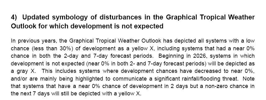
-
Just give me until Tuesday evening. Got field work on Monday and pouring concrete on Tuesday.
-

2026 Atlantic Hurricane Season
WxWatcher007 replied to Stormchaserchuck1's topic in Tropical Headquarters
Can't say I've seen the gray X before. RIP I guess. -

2026 Mid-Atlantic Severe Storm General Discussion
Eskimo Joe replied to Kmlwx's topic in Mid Atlantic
12z and 18z NAM looked decent but the 00z NAM is dry and boring as burnt toast. -
I have to say, I might be a bit biased after having my first fall and winter up there. Spring was rough--SLK was a ghost town in April--but my goodness it's wonderful up there. Just need to get a good squall line day up my way to complete it. Some folks in the Mid-Atlantic region used to organize a Midwest chasecation years ago. It'd be a hoot to have the regulars here crammed in a SUV driving through Kansas.
-
As warm as its been here we've been fortunate enough to avoid these extreme bursts as similar conditions here could yield 110+ highs.
-
Gorgeous day today. We met up with friends to watch the USA game in Old Town at an outdoor bar. Fantastic weather and even better atmosphere around us.
-
Best I can tell, the 3 spinners in VT this year so far is the most the state has had in a year on record, at least since 1975. Due to over-reporting after the 1953 ORH spinner through 1974 and the concept of a microburst not realized until the early 70s, I would not consider records before 1975 reliable. Of course, it wasn't until the mid 90s when we really started to detect and document much better what actually occurred for tors given the installation of WSR-88Ds and the NWS MAR. WxWiz be like be"MEH!" LOL.
-
Earlier today, it was 97 degrees at at least one location in Germany, France, and Spain.
-
Another 0.5-1.0” around the area today. 0.78” here. Looks like the I-89 corridor south of here saw the more consistent 1” totals. The heavier initial convergence band has slinked south, but there’s moisture stacked to Hudson Bay that’s going to be advected south into the NW slopes of the Appalachian chain all weekend. Can’t catch a break on these weekends.
-
Fortunately it’s been just below the threshold for flooding for us, although it’s been enough to take out of the the riverside trails on my property. But could have been much worse
-
And while the rain sucks, the mountains do look really pretty with the rain


