All Activity
- Past hour
-
Rare Staten Island beating the Bronx setup may be occurring if this depiction comes to fruition.
-
The storm that dumped 6 inches they didnt name and definitely deserved one
-
Thanks Don. The last storm where CPK was at 37 while north, south, LI and CT stations had 34 at the onset of the precip shook me.
-
Ukie
.thumb.png.c65183fa4c0ca2bc37ffeb0e75c455d1.png)
-
It will always be like this with the mean trough axis over us or to our east, which is pretty much where it's been the last two winters. Light dusters galore but when the big ones come, we warm up. Need the mean trough 500 miles to our west which is when we cash in with the big dogs. But of course, we always run the risk of Miller B's giving the goods to the EC. Climate..
-

White Christmas Miracle? December 23-24th
Great Snow 1717 replied to Baroclinic Zone's topic in New England
Steady snow with good snow growth. -
Finished dead last in my fantasy league this year. Lamar was my QB. Justin Jefferson was my top scoring threat.
-
Perversely, I think that definition makes me upstate.
-
Makes sense, everything south of there is the city.
-

Winter 2025-26 Medium/Long Range Discussion
Malacka11 replied to michsnowfreak's topic in Lakes/Ohio Valley
Is there any chance that this business on Monday could work out to be half an event for someone? Or just a total mirage? -

December 2025 regional war/obs/disco thread
Ginx snewx replied to Torch Tiger's topic in New England
Lol the board psychologist speaks. -
Would be interesting if we do have solid evidence, however wouldn't the catalyst be deeper west coast troughing?
-
I went to college in the Bronx and my uncle in Brooklyn used to ask me, "how are things upstate?".
-
(002).thumb.png.6e3d9d46bca5fe41aab7a74871dd8af8.png)
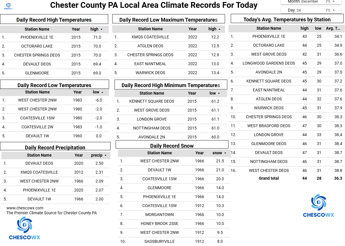
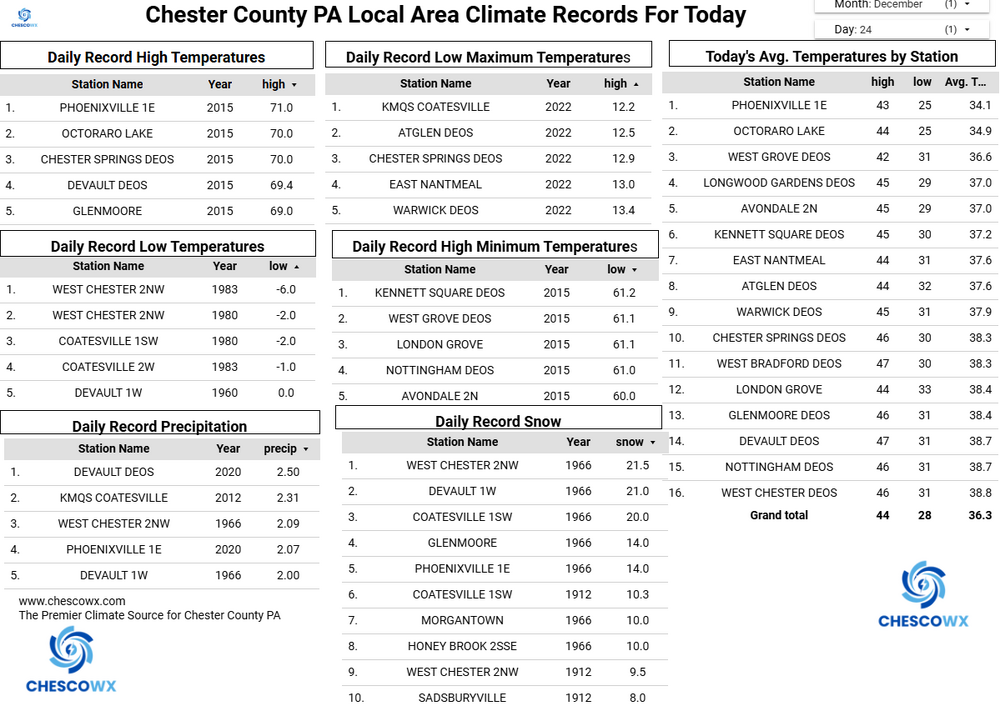
Central PA Winter 25/26 Discussion and Obs
ChescoWx replied to MAG5035's topic in Upstate New York/Pennsylvania
Merry Christmas to all of you! Dry and breezy with near normal temperatures today a slight chance of a shower or snow flurry tomorrow morning and then a significant winter event for the entire area by later Friday. This will not be a significant snow event but will be impactful with mixed precipitation that falls occurring with temperatures mainly in the mid to upper 20's. I suspect the predominant precipitation type will be sleet with increasing chances of freezing rain further south and more snow especially as we go north and east toward Trenton and NYC. Rain returns on Sunday night and we turn sharply colder again on Monday.
-
E PA/NJ/DE Winter 2025-26 Obs/Discussion
ChescoWx replied to LVblizzard's topic in Philadelphia Region
Merry Christmas to all of you! Dry and breezy with near normal temperatures today a slight chance of a shower or snow flurry tomorrow morning and then a significant winter event for the entire area by later Friday. This will not be a significant snow event but will be impactful with mixed precipitation that falls occurring with temperatures mainly in the mid to upper 20's. I suspect the predominant precipitation type will be sleet with increasing chances of freezing rain further south and more snow especially as we go north and east toward Trenton and NYC. Rain returns on Sunday night and we turn sharply colder again on Monday.
-
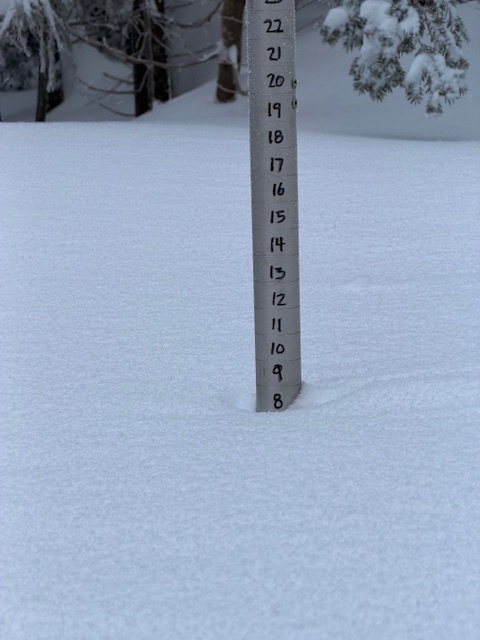
Healthy 8” (8.5) on the mountain.
-
Time for Upton to toss out a WSW. Expect it by 3-4pm.
-
Way more mixing. Can't use the snow maps
-
-

Snow Potential Dec 26-27
WestBabylonWeather replied to WeatherGeek2025's topic in New York City Metro
Starting at the Bronx and westchester border is upstate -

26th-27th event, coming at us like a wounded duck.
Kitz Craver replied to Go Kart Mozart's topic in New England
Right, we can always find a way to melt it down here, lol. Have to enjoy what we get when we get it. -

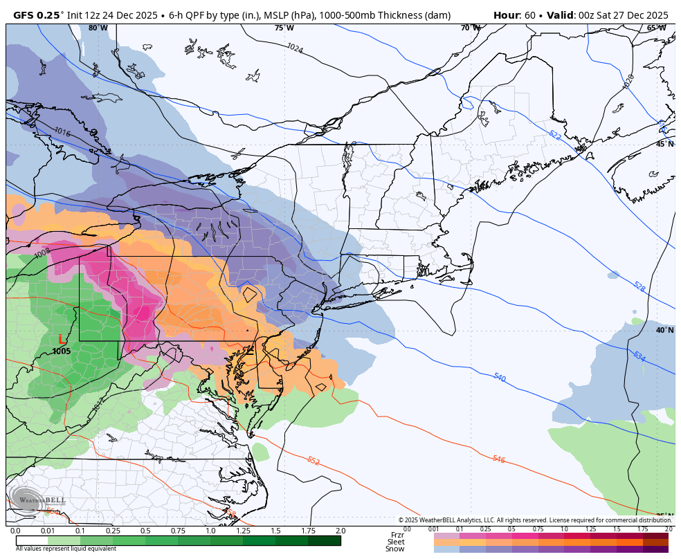
Central PA Winter 25/26 Discussion and Obs
Blizzard of 93 replied to MAG5035's topic in Upstate New York/Pennsylvania
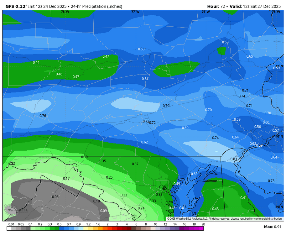
12z GFS is bringing .50 to .75 of precip into the cold dome. Hopefully heavy rates at the start can put down a little snow before the warming aloft kicks in, but it that amount of sleet would be impressive.
-
It does seem the SER is worse now and the 50/50 region trofing is not there as much. Here are 2 setups from the 80s which nowadays I would bet result in much more massive SERs than they did back then. Notice in both cases the low heights in the NW ATL, now it seems that feature is there less. https://www.meteo.psu.edu/ewall/NARR/1989/us0205.php https://www.meteo.psu.edu/ewall/NARR/1985/us0204.php
-
Everything north of Spuyten Duyvil is upstate, right?
-
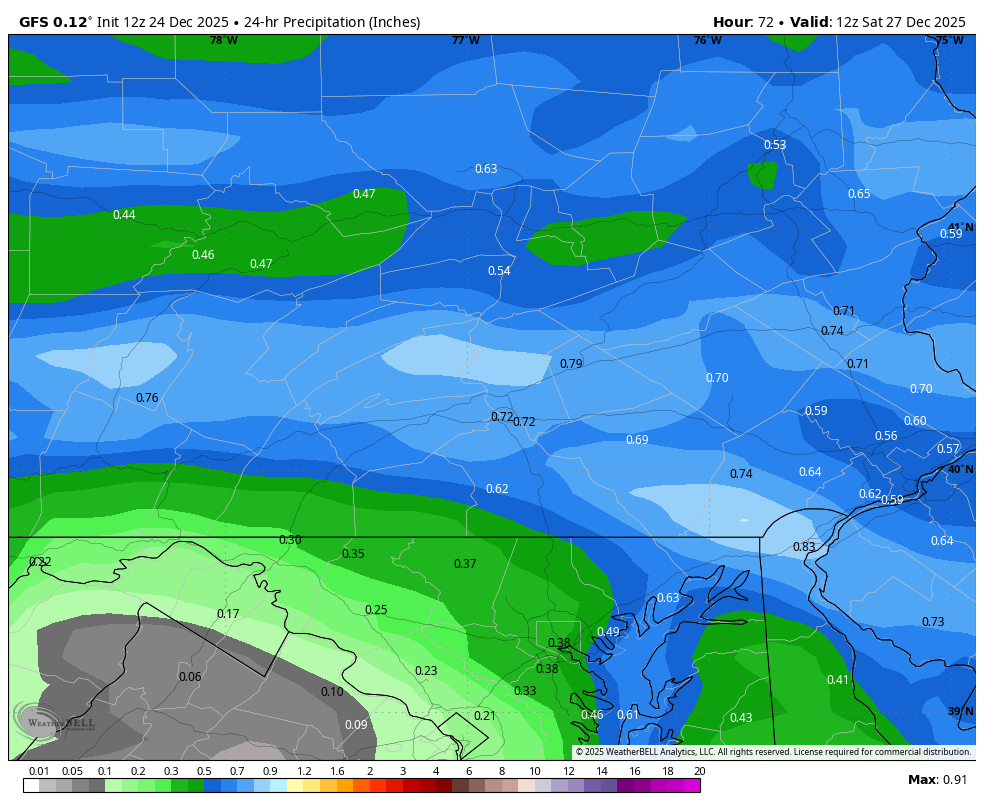
CMC looks good! Similar to GFS


.png.d5b2d9306a0482a3da68befbeb778558.png)