All Activity
- Past hour
-
 Feet of snow and the Patriots are headed to the Super Bowl, it doesn’t get better than this
 -
 Epic snowstorm and a patriots Super Bowl Lfg
 -
 I made it to 0.1 f
 -
It’s not, it’s based on distance from the radar site-radar beam elevation. Way out east it’s showing that once the radar beam reaches probably 6000 feet or so it’s picking up a mix. I don’t have the tool to show the radar beam elevation so far from the radar site but it must be about 6000 feet or so. In N NJ it’s closer to the radar site and the radar beam is at a lower elevation which is how it picks it up.
-
No I appreciate. We'll see what happens with it in the future.
-
28.6….glaze getting serious. At least .1”. Hard to measure…have a metal railing where I usually measure…down several steps….don’t want to break my neck.
-
Back end needs to do the typical DC thing and fly threw
-
I thought someone was getting 3 feet
-
 Winters of f'ing yore! Super bowl. IPAs loin cloth in the yard. White out .
 -
11/30/2025: T (A mix of rain/sleet from the 4am hour through about 9am. Intensity got up to light/moderate intensity at times. Temps: low/mid 30s 12/02/2025: T (Probably had a brief period of sleet w/ rain sometime between 4:30am and 5am when precip started before quickly changing to a cold rain that became moderate at times during the morning.) 12/05-06/2025: 1.4" (Flurries/very light snow starting in the 4am hour intensifying to light snow between 6am and 10am (light/moderate at times). Flurries to very light snow showers continuing through the rest of the morning ending during the 12pm hour. ETA: Another few bursts of sometimes moderate snow with big aggregates between 10:30pm and around midnight or so dropping an additional 0.2".) 12/11/2025: T (A few flakes in the air during the morning on a northwesterly surface wind.) 12/14/2025: 0.9" (Mixed rain/snow starting after midnight on the 14th, changing over to snow sometime during the 3am hour and lasting through about 6:30am. Snow was moderate at times between 4am and 5:45am. It was graupelly in consistency.) 12/26/2025: T (A mix of light rain/sleet between 10:30am and 12pm. It was briefly freezing rain/sleet as temps fell to 31F during the precip.) 1/01/2026: 0.1" (A squall of heavy snow blew through between 5:18am and 5:35am with visibilities dropping to <= 1/4 mile briefly between 5:21am and 5:25am. Note: could have been 0.2" but the wind 25-30mph gusts made it difficult to tell.) 1/11/2026: T (A few wet flakes with a dying snow/graupel squall around 1:30-1:45pm.) 1/17/2026: 0.4" (Flakes started falling around 8:45am. At 8:48am intensity rapidly jumped from flurries to moderate+ within 15 seconds. Between 9-9:05am the snow was fairly heavy at times. Snow tapered off to flurries by 9:15am. There was a snow/graupel mix that briefly got up to light/moderate intensity around 10am. Snow/graupel tapered off by 10:30am as the last flakes concluded.) 1/18/2026: T (Off and on light rain, probably mixed in with mangled flakes predawn (1:30am-6:30am). An afternoon round of flurries between 4 and 5pm.) Snow totals as of January 18th, 2026: 2.8" Update on current Jan 24-25th storm later once frozen precip ceases.
-
 6PM Update: 9.1" (1.0" from last hr measurement) 19F, up 8F Pats to the super bowl as we stack, LFG!!!
 -
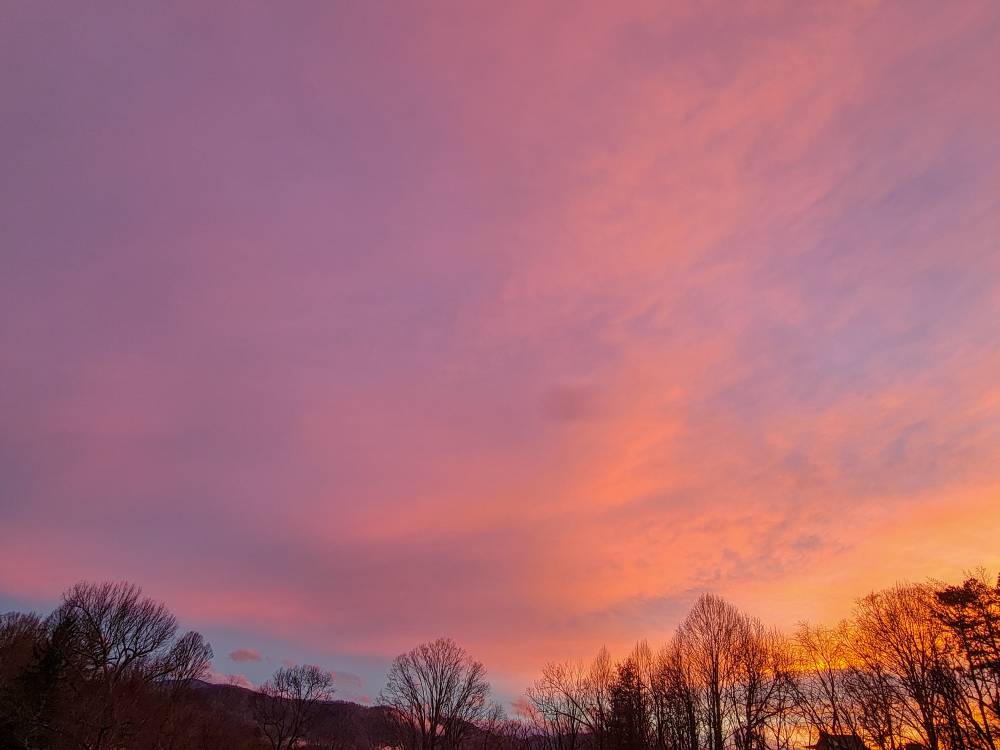
A beautiful sunset this evening. Sent from my SM-G998U using Tapatalk
-
Wow, just wow. Easily past 15" with 70 feet of driveway piles head high or better and visibility is still less than 2 blocks, so about 500 feet. Temp is up 10° and shit is getting dense and heavy. 35/35/E5G14/SN+
-
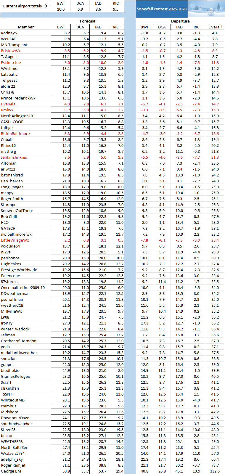
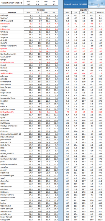
The updated total for this storm are BWI 7.6, DCA 5.3, IAD 6.2, and RIC 3.5. See new leaderboard below, pending further updates this evening.
-
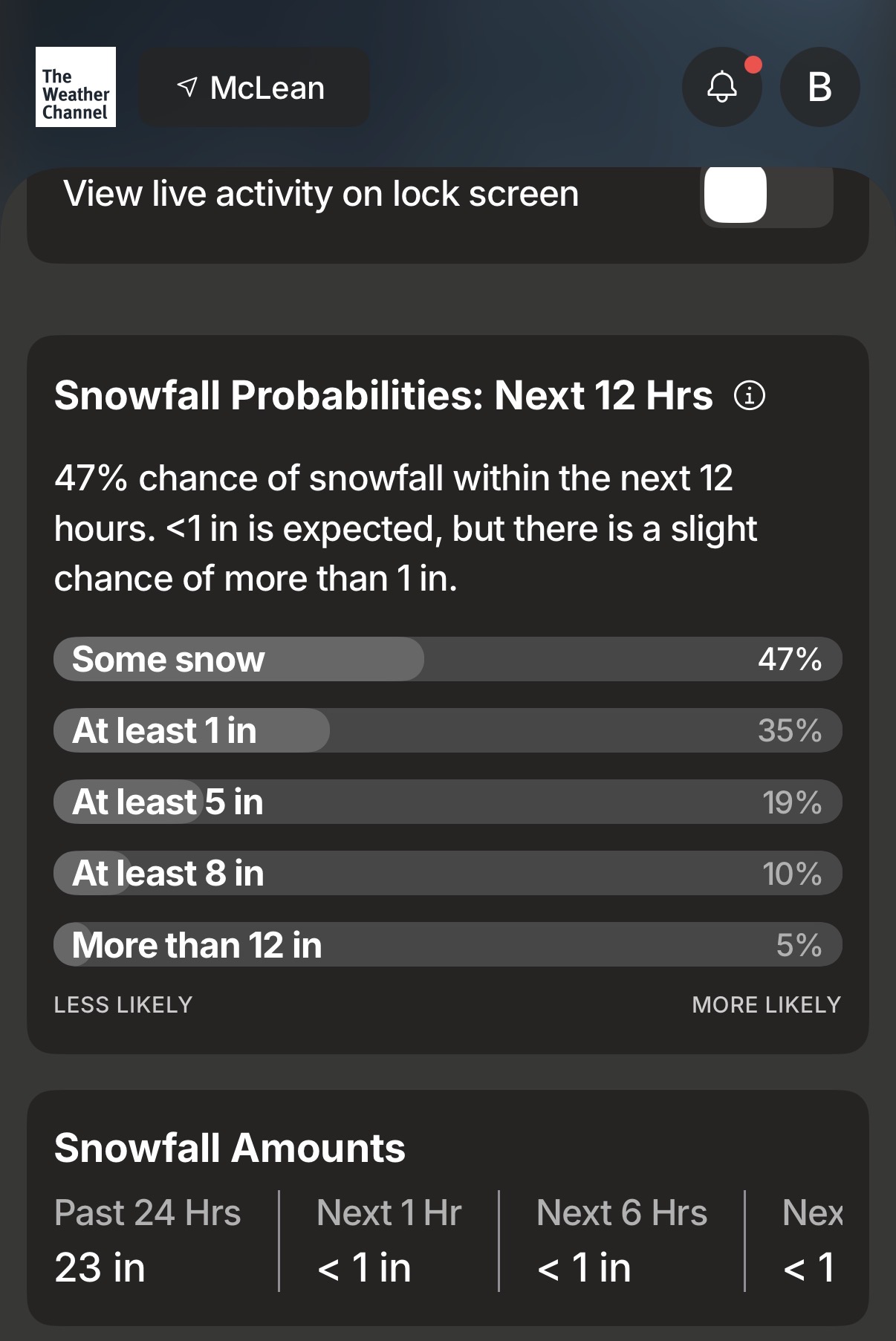
Thanks for 23”, TWC!

-

January 24-26: Miracle or Mirage OBS Thread!
nw baltimore wx replied to Jebman's topic in Mid Atlantic
Of the glacier or the ambulance? -
1.20" sleet Little angry about getting cheated with sleet with so many heavy sleet reports. It's been falling at not quite .25" hour since the change.
-

January 25-26 Winter Storm Potential
CoolHandMike replied to Ralph Wiggum's topic in Philadelphia Region
Same here, temp back down to 10.2°F. It briefly touched over 11 earlier today. -
 My uncle's brothers sister nephew in East Bumfuck reportedly saw a sleet pellet
 -
I don't know how most people will get places tomorrow. I just measured the sleet in the back and front of our townhome complex and lol... All of the sidewalks and parking lot coming out of people's garages are under 1.5' of sleet because it has all just flowed from the roof. Also, Gaithersburg right now and I am sitting at 3.6" of sleet on top of 6" of snow measured earlier. Just 0.4" to break double digits, don't know if I'll do it.
-
Freezing rain in the mountains is a very localized thing the models can't handle. No doubt the strength of the CAD brought a bigger threat to higher terrain than usual. Still surprised you had as much as as you did. Had very little which is consistent with what I have experienced with freezing here the past couple of decades.
-
Just took a walk and this crap is easily as bad as 15" of snow. Dense and slippery, like walking on a pile of dead fish but without the smell luckily.
-

Pittsburgh/Western PA WINTER ‘25/‘26
Rd9108 replied to Burghblizz's topic in Upstate New York/Pennsylvania
KPitt is that you? -
Yeah man, I’m super jealous of my peeps up north. This is turning into a classic for them with HOURS to go