All Activity
- Past hour
-

Possible coastal storm centered on Feb 1 2026.
ineedsnow replied to Typhoon Tip's topic in New England
That's the thing could models be overdoing it? models have been showing low development all over.. IDK seems we might have some surprises coming.. I also think we have to see where convection forms before models really latch on.. whether that means further OTS or further west.. we wait.... -

The “I bring the mojo” Jan 30-Feb 1 potential winter storm
AGardiner87 replied to lilj4425's topic in Southeastern States
https://www.facebook.com/share/p/1CyEmqZGQn/?mibextid=wwXIfr Nice write up from former CLT meteorologist Eric Thomas. -

Richmond Metro/Hampton Roads Area Discussion
wasnow215 replied to RIC Airport's topic in Mid Atlantic
Anybody have the 18Z NAM regular clown map for snow? -

Possible coastal storm centered on Feb 1 2026.
Typhoon Tip replied to Typhoon Tip's topic in New England
I don't disagree with Scott's observations there; spoke similarly about the unusually rich volatile instability there being "too much of a good thing" yesterday I'll just add that the convection it's self is racing away along the streamlines out there. We're lacking a lot of more typical N-S orient curvature in the escape orientation of the isohypses. If we had that normalcy in place it would probably help contain and low further W and other feedbacks ... it's just idiosyncratic about this particular event to be missing that. -
Richmond Metro/Hampton Roads Area Discussion
wasnow215 replied to RIC Airport's topic in Mid Atlantic
I love reading your stuff in the DC thread! You are always welcomed here. I just find that model and HRRR to be pretty poor even when you get to "during the storm" lol. By the way I'm not even sure if people know who I am in that thread but I've been here I think since 2012-and I do post on there sometimes. I think I was on the other one too whatever it was called when I lived in New Jersey. Eastern? I think that's what it was called something like that. -

January 30th- Feb 1st ULL and coastal storm obs
marsman replied to JoshM's topic in Southeastern States
34F and 13 DP. -
Glad I am far out east!
-

February 2026 Medium/ Long Range Discussion: Buckle Up!
wxmeddler replied to Weather Will's topic in Mid Atlantic
The last week has felt like when I was living in Fargo, it's been great. -

Jan 30th-February 1st 2026 Arctic Blast/ULL Snow OBS Thread.
jaxjagman replied to John1122's topic in Tennessee Valley
Light snow shower,it wont last much longer it seems ATM -
Very little melting here even the south facing roof has little melt, I did snow rake the bottom 2 feet.
-

The Jan 31 Potential: Stormtracker Failure or 'Tracker Trouncing
WEATHER53 replied to stormtracker's topic in Mid Atlantic
Odd to me how this storm has a pronounced “U” formation to the precip shield . I don’t think that dramatic of a dip will occur so the outcome of this not set in stone -

Arctic Hounds Unleashed: Long Duration Late January Cold Snap
CoastalWx replied to WxWatcher007's topic in New England
High of 15 here. -
Yuck.
-
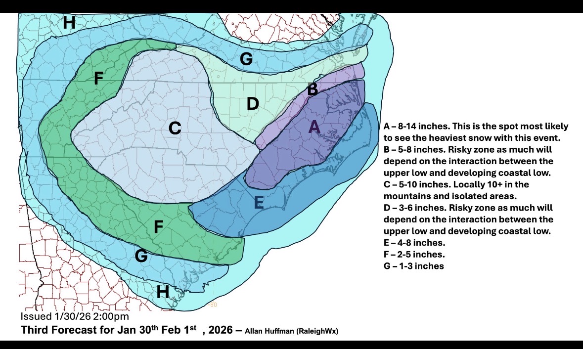
Man all mods are consistent with Knox getting the sharp cutoff with an average of around 5 inches.
-

The “I bring the mojo” Jan 30-Feb 1 potential winter storm
Snowncanes replied to lilj4425's topic in Southeastern States
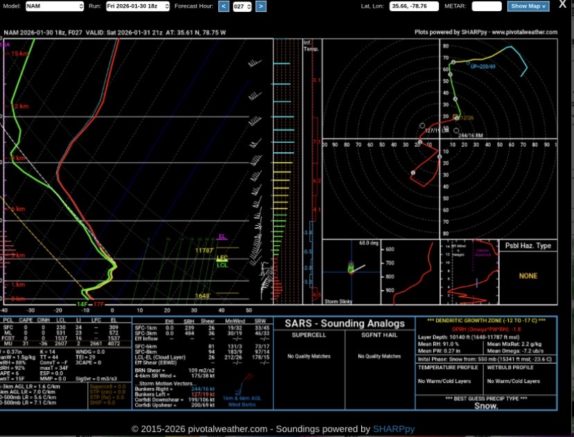
HRRR vs NAM soundings for wake county. That low level dry air just makes no sense, where is it coming from? Also look at the massive DGZ (yellow lines on the right) on the NAM. Thats some beautiful heavy snow.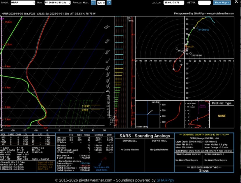
-

The “I bring the mojo” Jan 30-Feb 1 potential winter storm
wxdawg10 replied to lilj4425's topic in Southeastern States
2 pieces of energy are trying to come together by grabbing hold of eachother while spinning into eachother's momentum as they run full speed.. imagining two people doing that seamlessly is hard enough. imagine massive and turbulant weather systems on a global scale.. Would imagine it would be a difficult concept for computer models to grasp fully -

The “I bring the mojo” Jan 30-Feb 1 potential winter storm
Isopycnic replied to lilj4425's topic in Southeastern States
I’m riding the NAM till this storm threat dies! -

Jan 30th-February 1st 2026 Arctic Blast/ULL Snow OBS Thread.
John1122 replied to John1122's topic in Tennessee Valley
Anyone in the mid-state seeing anything from that band? -

Possible coastal storm centered on Feb 1 2026.
weathafella replied to Typhoon Tip's topic in New England
Awful timing personally but we take what we get. Hopefully it’s warmer the following week. -
Richmond Metro/Hampton Roads Area Discussion
wasnow215 replied to RIC Airport's topic in Mid Atlantic
Regular nam is much better -
Possible coastal storm centered on Feb 1 2026.
CoastalWx replied to Typhoon Tip's topic in New England
These stupid lows keep messing up what could have been a decent warning event at least to BOS. But they might be real since you have tremendous instability and forcing over the gulf stream. Sometimes these have some near term surprises...but guidance is fairly locked in. -

The “I bring the mojo” Jan 30-Feb 1 potential winter storm
Regan replied to lilj4425's topic in Southeastern States
And he bumped up here in Wake down. Right as I was getting excited about the Nam. I mean… at least gimme 6.
-
.thumb.png.82d6a1aaa2897695ec67f6031d37d4ab.png)
-

The “I bring the mojo” Jan 30-Feb 1 potential winter storm
Tony Sisk replied to lilj4425's topic in Southeastern States
Ok, I would take that right now for all of SC, But don’t let what is showing in the Triad happen. They deserve in on the action. -
Still has me under 6 inches with that annoying leeside area but I think its overstating it.
.thumb.png.8357329a5aedc4c79a9e22ee568a5785.png)


.png.cf10fa0317a42ea0d9fea92901978c88.png)
.png.c675c26f9d9d7365cc832ae4822f0e90.png)