All Activity
- Past hour
-
Absolute split screwjob. Went right around me on both sides. House-shaking thunder and now the line has consolidated as soon as it got north of me. JFC.
-
Planck feedback/response stops any sort of Venusian runaway on this planet. Would take much higher insolation to get us there. Much more worried about plant and/or soil carbon stock turning unstable at current temperatures. It's been showing signs the last few years, esp with large emissions from respiration. South America and southern Africa in particular do not seem to be taking it well. Some of this is probably due to monsoon trough migration via differential hemispheric heating and boosted non-CO2 warming recently from aerosols and higher-than-trend CH4, causing a lopsided NH response. But if the Amazon and southern African tropical sinks can no longer provide a brake, then that will cause an immediate and relatively strong increase in the airborne fraction.
-

2024-2025 La Nina
PhiEaglesfan712 replied to George001's topic in Weather Forecasting and Discussion
I really hope not. We're already getting lows in the 80s here in PHL. I can't imagine living through lows of 90 and highs near 110. -
Wow, JB doesn't seem to understand the difference between an ice sheet and sea ice. Odd.
-
Nice thunderstorm picked up 0.45” in 10 min 0.95” total so far since Saturday hoping for another round later this evening
-
What’s the statewide record there?
-
Hmmm Area Forecast Discussion National Weather Service Baltimore MD/Washington DC 254 PM EDT Mon May 5 2025 .SYNOPSIS... A cold front will slowly progress eastward across the region through Tuesday, then pull offshore Tuesday night. High pressure will follow briefly for Wednesday. A potent cold front is expected to move southeast from the eastern Great Lakes to and across the Mid-Atlantic late in the week. High pressure will likely follow through the upcoming weekend. && .NEAR TERM /THROUGH TONIGHT/... Isolated severe t-storms will be possible over the next couple of hours with current scattered activity across the area. However, it appears the main severe wx potential over the next 12 hours will be tied to the line of convection forming near Raleigh NC. Shortwave-trough lifting from southwest VA into western VA and low-level convergence are expected to encourage more widespread convection early this evening. Latest HREF fields suggest a broken to solid line of thunderstorms forming from near Frederick MD south to Fredericksburg. Given cooling aloft and some rotation already seen on radar, a tornado and hail threat exist, especially given that shear profiles are expected to strengthen. The main window for severe wx potential looks to be between 21Z-02Z. Convection is expected to weaken or lift north into Pennsylvania after 02Z.
- 467 replies
-
- 1
-

-
- severe
- thunderstorms
- (and 2 more)
-
Got hit pretty hard by the cell that is now rolling through central MD northwards; heavy rain for ~20 minutes. That will pad my paltry totals. I think with round 3 later tonight I should end up over 1.5" which is pretty close to what was modeled before the weekend. But hit and miss for sure around and east of 95
-

2024-2025 La Nina
TheClimateChanger replied to George001's topic in Weather Forecasting and Discussion
Not sure I buy that. It looks like a 5-period moving average is near the maximum for 90-degree days at both LGA and EWR, with the LOESS curve predicting the highest value of 90+ days in the POR at both sites. Looks like we are on the precipice of a big upswing in heat. Even a small additional increase in 90+ days would likely push your area outside of historic norms. Also, as I have noted numerous times, the heat spike from 1986-1995 very likely an artifact of the data collection due to the defective HO-83 sensors in use during that brief era. The increase in 90+ days matches up temporally with the proliferation of HO-83 units. After installation of ASOS, the 90+ days rapidly drop back to pre-1986 levels, from which they have since steadily climbed. The impact of the HO-83 cannot be dismissed a small bias. It was a substantial bias, the magnitude of which varied by site. At Lincoln, Nebraska, it averaged nearly 2F warmer than the ASOS, although at times, it could be as much as 7F warmer. See: Central Region Technical Attachment 93-07, Comparison of ASOS and HO83 Temperatures at Lincoln, Nebraska from November 1991 through October 1992, George H. Grosshans, NWS Lincoln (1993). -
Thanks, cloudy and drizzle, deer and turkeys seem happy. Hopefully we tap into a better setup, lack of surface heating isn't helping. Sent from my Pixel 9 using Tapatalk
-
CAR's hottest is 96, reached once in May and twice in June. Modest dews, a bit of downsloping from west wind (not SW, too much water to heat), heat records.
-
It might get real interesting around here and it could turn out to be a storm where I get very little slushy accumulation on Tuesday here at ~7300', while my neighbor who is 200' above me gets heavy cement worthy of plowing.
-
It just sucks when when you have the weight of stupidity at the one end of the boat that has the hole while all those who know know better have no choice but to be ON THE SAME BOAT
-
I didn't realize it but the group that purchased Burke includes Jon Schaefer from Berkshire East. He sent out an email a little while ago that they'll have a whole new snowmaking system ready for next year. Should be beneficial to the mountain and the local community I would think.
-
.thumb.jpg.6a4895b2a43f87359e4e7d04a6fa0d14.jpg)
Central PA Spring 2025
Yardstickgozinya replied to canderson's topic in Upstate New York/Pennsylvania
It may be nuts for some, but It really is all about the angle in the dangle today.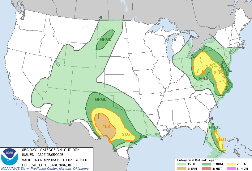
-
picked up .86 in about 20 minutes. Sitting at 2.42" now for the drought buster
-
damn...auntie em auntie em!!!
-
man it is dumping out there right now my weather station saying 2" hr and .40 in the last 10 minutes this will ge me over 2" for the event
- Today
-

Central PA Spring 2025
Mount Joy Snowman replied to canderson's topic in Upstate New York/Pennsylvania
A baby-nado, if you will. It's funny, we were driving down 222 back from the Poconos right around that time and weren't far from that location when I pointed out to my wife what looked to be a nasty little cell. Sure enough. -
Don't worry. The euro will save us Friday lol
-
Yes the NE coast and parts of the upper midwest have had increased snow since 1970. That's consistent with the paper I posted upthread (relinked below and added a second). As expected the snowfall signal is emerging much slower than the temperature signal due to offsetting precipitation and temperature effects and natural variability. https://journals.ametsoc.org/view/journals/clim/26/20/jcli-d-12-00832.1.xml https://agupubs.onlinelibrary.wiley.com/doi/pdfdirect/10.1029/2018GL079820
-
Wow
-
ended here before 2 pm
-
Central PA Spring 2025
Mount Joy Snowman replied to canderson's topic in Upstate New York/Pennsylvania
EFO tornado confirmed yesterday afternoon down here in Lancaster County near Denver. About as small as you'll see though, only on the ground for a single minute, with a path width of only 10 yards and a path length of a tenth of a mile. -
The other way I know the warm ridge idea has legs is because every time since the mid 20teens there's one in the model, the operational GFS canes Cuba/Bahamas. it's like responding to numerical instability more than an actual system and then spontaneity in the physical processing of the model takes over and it just fabricates one - but it requires the deep layer easterly anomaly to the circulation mode down there, which is what happens when? duh duh dunnn... there's ridge over the eastern CONUS.


