All Activity
- Past hour
-
Perfectly normal “behavior” for every IOD cycle, positive or negative. They peak in Northern Hemisphere fall (usually October) then start to rise/fall and neutralize in winter. This is the strongest negative event in over 17 years
-
As expected, severe drought has spread into central NC as far west as Wake county. Meanwhile a pocket of severe drought conditions have developed SE of Charlotte as well. Widespread rain looks possible next week and will be more than welcomed given the rapidly escalating drought conditions across the state. Some areas have seen under 2” of rain total since the second half of August
-
32 this morning after a forecast low of 38.
-
Oh, Nice catch! There was a band of clouds there pretty much all night, blocked the longwave radiation cooling. Likely also prevented a sturdier inversion from developing and calming the winds at the surface.
-
Can't be a rug pull if ya don't believe it from the beginning. Literally any model solution that shows a hit we have to throw it out. We know what the limitations of both the nina and the -PDO regime are, right? So like...why give a "good" model run showing something different the time of day? Better to just ignore it!
-

Spooky Season (October Disco Thread)
H2Otown_WX replied to Prismshine Productions's topic in New England
We just don't know how much wind, no one does -
I do not know how it could keep major status let alone hurricane status coming that close to Jamaica.
-
Can she be gone if she was never here?
-
Buckle up friend....gonna be a long winter of rug pulls
-
Poor Jamaica
-
Lucky
-
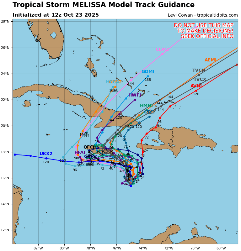
I'd also want to emphasize that until Melissa starts to vertically stack and become better organized, there may continue to be disagreement in model guidance in the short-term because of their proposed placement of the final organized, stacked circulation.
-
It’s highly likely that the IOD is now near its lowest of this cycle per climo. Met. autumn is by far the season when they dip the furthest in a cycle. This is the link to NOAA monthly IODs back to 1870 (I think I got this from snowman): https://psl.noaa.gov/gcos_wgsp/Timeseries/Data/dmi.had.long.data Looking back to 1950, these were when the lowest cyclical monthly lows (<-0.7) were hit: 7/2016, 10/1998, 10/1996, 6/1992, 6/1989, 9/1981, 8/1980, 10/1975, 10/1974, 9/1973, 9/1971, 9/1968, 10/1964, 10/1960, 8/1959, 9/1958, 7/1956, 9/1955, 7/1954 Analysis: -# months since 1950 with these minimums: Sept and Oct each had 6 followed by July with 3, and June and August each with 2. So, all were June-Oct. So, IOD tends to dip to lows ~3 months earlier than ENSO dips. -With no sub -0.7 cyclical low since 1950 in Nov, it would be very surprising if the IOD didn’t rise substantially next month. -Sub -0.7 months have been much less common since 1998 as overall average IODs have risen substantially -Positive IOD months used to be pretty rare but since 2006, 60% have been positive. Since 2017, 70% have been positive! -1870-1899 had 6% positive, 1900-1924 had 4%, 1925-49 had 8%. There were positives in 12% of months during the 1950s. 28% during the 1960s, and 33% during the 1970s. There was a temporary drop back to 23% during the 1980s. Then positives rose to 37% during the 1990s, 43% during the 2000s, 59% during the 2010s, and 60% during 2020-4. Does anyone know why the average IOD has risen so much since the early 1900s and continues to rise?
-
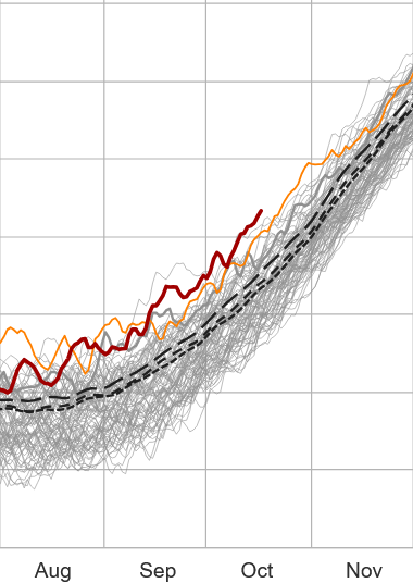
Kinda interesting. Not sure if there's any actual predictive usefulness to this philosophy outlined below, but could we be setting up 2026 as another ...holy shit, didn't see that comin' global leap in temperature? This is the current winter escape curve in the southern hemisphere ( provided by https://climatereanalyzer.org/clim/t2_daily/?dm_id=sh ). It's presently the warmest October on record down there? That's equivalent to late February up here. So then heading through their "March" and "April" ...when solar really is accelerating ... where is this curve destined? (dark rust) Intuitively/simple additive thinking might be setting up a high launch pad for the world, whence the N. Hem. spring of 2026 starts dumping in its typically warm quota ( due to having greater land integral).. The ongoing tendency that our immediately ensuing winter will end up above normal overall (not compensating in the averaging) notwithstanding. Just some wondering here -
-
Obviously terrible flooding situation but that would be nonstop land interaction to keep it somewhat in check intensity wise
-
Will the wind ever stop?
-
How’s the pac jet looking for this winter?
-
Quite a shift east in the past day or so on the spaghetti hurricane guidance. The turn to the west is much shorter duration and Melissa gets pulled north and northeastward much quicker.

- Today
-
She's a cutie, love beagles.
-
Frost advisories and Freeze Warnings hoisting in North Carolina and Virginia
-
Upper 20s were scattered across western, northern, and east-central Iowa this morning. The Cedar Rapids airport briefly hit 28º. Here in the city there was just a light skin of ice on the bird bath and some light frost. Tomorrow morning should be a bit colder.
-
Lucky, or do you use deet spray?
-
I had one all year. And I practically live in a field.
-
Absolutely love beagles! Although they can be a pain in the ass.
-
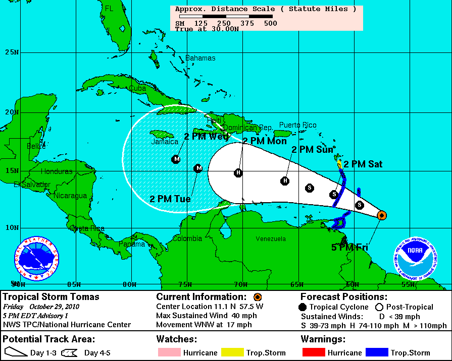
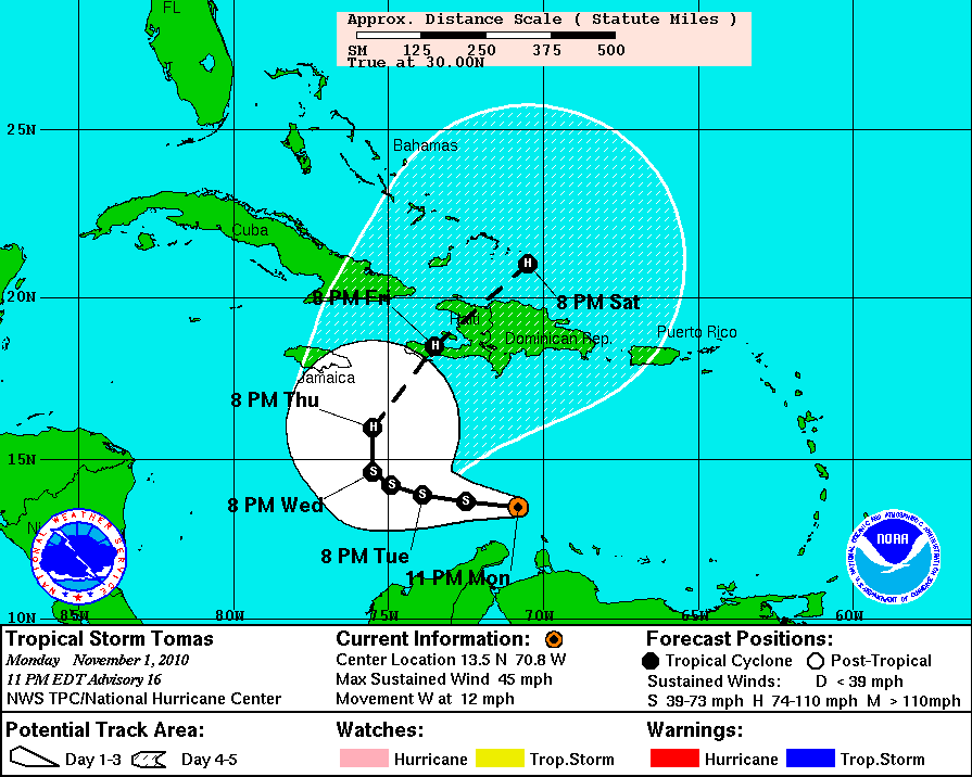
I know everyone's forgotten this storm but it's reminding me of hurricane Tomas for some odd reason. Not sure why but I do know it was predicted to become a powerful major hurricane once it entered the Caribbean and people were very bullish on it. It struggled immensely and was still a tropical storm where it was predicted to become a major lol. Definitely one of the worst intensity forecasts I've ever seen from the NHC. Not saying Melissa is going to under perform but we are in the Caribbean 'graveyard' after all. Normally storms that enter the eastern Caribbean struggle to develop at all unless they are well established before entering. Also NHC's intensity forecasts are a lot better now than compared to 15 years ago but it is still the hardest part to forecast in a hurricane.