All Activity
- Past hour
-
I'll sell that 87º the 12z GFS had for us on Friday. GFS continues its warmista saga.
-

Strong Nor'Easter/Hybrid Storm Late September 2026
Neblizzard replied to Rjay's topic in New York City Metro
What are the models showing for later today and tonight ? I don’t have access currently . -
Yeah, there’s an impressive, and annoying, amount of shredded leaves and twigs covered everything. Needed to use the blower on my windshield. Up to .53” with much less wind now and constant drizzle/mist.
-

October Comes Early: Late September Multi-Hazard Hybrid Storm
WinterWolf replied to WxWatcher007's topic in New England
CAA from the south….that ain’t something you see very often. That certainly was one for the record books Thanks for the info. -

October Comes Early: Late September Multi-Hazard Hybrid Storm
CoastalWx replied to WxWatcher007's topic in New England
Man if only your 3rd wife had that. -

2026-2027 Record-breaking El Nino
GaWx replied to Stormchaserchuck1's topic in Weather Forecasting and Discussion
Looking at El Niño seasons that at some point maxed out at +2.0C for a trimonthly in Nino 3.4 (using Eric Webb’s tables for pre-1950 and the latest version of NOAA RONI for 1950+), this is what followed in ASO as well as the subsequent fall/winter: 1877-8: ASO +0.1 followed by cold neutral 1888-9: ASO -1.1 followed by strong La Niña 1965-6: ASO 0.0 followed by cold neutral 1972-3: ASO -1.3 followed by strong La Niña 1982-3: ASO -0.6 followed by moderate La Niña 1991-2: ASO +0.1 followed by weak El Niño 1997-8: ASO -1.2 followed by strong La Niña 2015-6: ASO -0.9 followed by moderate La Niña Tally for these 8 strongest El Niños on record: 5 La Niña (3 strong, 2 moderate) (62.5%) 2 cold neutral (25%) 1 weak El Niño (12.5%) So, this suggests the best chance is clearly for La Niña although it also suggests to not dismiss the possibility of something else, mainly cold neutral, especially IF this were to peak later than model consensus has been suggesting (say, in Jan instead of Nov). Of the 3 of these that didn’t go to La Niña, 1877-8 peaked between NDJ and DJF while 1991-2 peaked in DJF. OTOH, 1965-6 peaked early (OND) and still didn’t go all the way to La Niña the following year as it stopped at cold neutral. Note that the 3 that were neutral in ASO never made it to La Niña. ____________________ Sources of data: 1. Webb’s tables (used for pre-1950): https://www.webberweather.com/ensemble-oceanic-nino-index.html 2. NOAA RONI (1950+): https://www.cpc.ncep.noaa.gov/products/analysis_monitoring/enso/roni/ -
October Comes Early: Late September Multi-Hazard Hybrid Storm
WinterWolf replied to WxWatcher007's topic in New England
Just a matter of time…whether we live to see it is another story lol. -

October Comes Early: Late September Multi-Hazard Hybrid Storm
WxWatcher007 replied to WxWatcher007's topic in New England
Can you imagine a storm like that today in our backyard? Unbelievable. -

Strong Nor'Easter/Hybrid Storm Late September 2026
straphanger replied to Rjay's topic in New York City Metro
Came out for about 20 seconds in Queens. It got noticeably brighter for about 15 minutes but it's back to gloomy for now. -
October Comes Early: Late September Multi-Hazard Hybrid Storm
DavisStraight replied to WxWatcher007's topic in New England
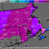
Wow, 57 inches in Pickens -

2026-2027 Record-breaking El Nino
mitchnick replied to Stormchaserchuck1's topic in Weather Forecasting and Discussion
Keep in mind that if you're more interested in winter weather, a snapshot of June's Enso is generally irrelevant. -

Strong Nor'Easter/Hybrid Storm Late September 2026
donsutherland1 replied to Rjay's topic in New York City Metro
There has been a little sunshine at Robert Moses. -
October Comes Early: Late September Multi-Hazard Hybrid Storm
CoastalWx replied to WxWatcher007's topic in New England
Over 5.6” now -

E PA/NJ/DE Autumn 2026 Obs/Discussion
The Iceman replied to PhiEaglesfan712's topic in Philadelphia Region
2.1” on the storm 7.2” on the month -

October Comes Early: Late September Multi-Hazard Hybrid Storm
Baroclinic Zone replied to WxWatcher007's topic in New England
Yep, just keeps on going. 5.6” -

2026-2027 Fall/Winter Mountain Thread
franklin NCwx replied to BlueRidgeFolklore's topic in Southeastern States
Same here! Had to wear a sweatshirt to the gym -

October Comes Early: Late September Multi-Hazard Hybrid Storm
dendrite replied to WxWatcher007's topic in New England
The Great Appalachian storm https://en.wikipedia.org/wiki/Great_Appalachian_Storm_of_1950 We were in the warm sector. That was a LLJ on roids…east flow and we were pulling near hurricane force sustained. Then the cold front went through from the south toward midnight…we had CAA from southerly flow, but the wind diminished behind the cold front. There was a point the next morning where it was snowing at BDR and raining at BDL. -

Strong Nor'Easter/Hybrid Storm Late September 2026
FPizz replied to Rjay's topic in New York City Metro
Good luck today -

Strong Nor'Easter/Hybrid Storm Late September 2026
MJO812 replied to Rjay's topic in New York City Metro
Sun trying to come out here -

October Comes Early: Late September Multi-Hazard Hybrid Storm
NeonPeon replied to WxWatcher007's topic in New England
This storm IS the monotony with kids at home and ceaseless drizzle. -

Strong Nor'Easter/Hybrid Storm Late September 2026
MANDA replied to Rjay's topic in New York City Metro
Lots of discussion over the last few days about how this storm should be classified. No shortage of opinions from several respected Mets. These two X posts make the most sense to me. It was shallow warm core and it did separate from fronts for a short time. No matter what it was not your typical cold season Nor-Easter and was not purely tropical. Hybrid or Sub-Tropical designation seems best way to go IMO.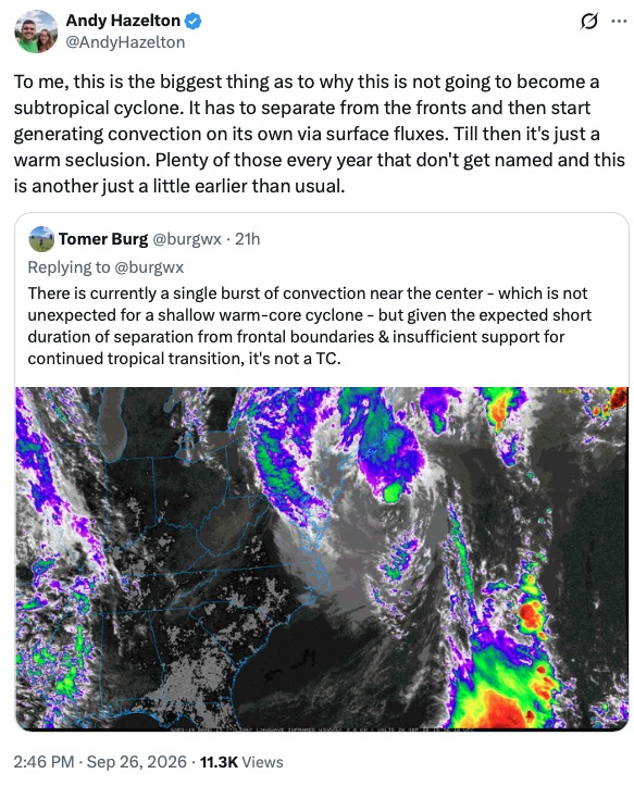
-
Probably at or over 0.5” for the weekend now?
-
I think this would be an unusual track for any time of the year! I can't recall a storm since Sandy that went retrograde.
-

Strong Nor'Easter/Hybrid Storm Late September 2026
uofmiami replied to Rjay's topic in New York City Metro
Post Sandy PSE&G has been more aggressive with cutting back trees from the lines, especially transmission lines. They also did a lot of FEMA money replacement projects of the transmission lines too. Perhaps it’s paying off or it’s just pure luck the outages weren’t worse. -

Strong Nor'Easter/Hybrid Storm Late September 2026
steve392 replied to Rjay's topic in New York City Metro
Minor flooding again from high tides on hackensack river. Up to 1.75" of rain so far. Coming down good again. Winds dying down a bit.