All Activity
- Past hour
-
The overall tenor for a big winter we're currently dancing to from the social media speakers is emerging out of the CPM: "crowd physics model" For me anywho, it can't be geo-physical. There are certain aspects that are not refutable - those that attempt to do so, deny CC while telling everyone out of the other side of their mouth that they are not deniers. The recent 10 or so year's worth of winters have rattled scaffolding of the out-of-classical teleconnector application: air and seas. These winters are showing a consistent shear stressed, mid and upper level velocity saturated hemisphere, regardless of the aforementioned states. Also, a time span in which I've read a lot of peer reviewed material elucidating these behavior changes as directly observed and CC-attributable. That is not going away. Certainly not because crowd noise is resonating to some emerged popularity. You're not asking me... but, I've mentioned recently that I do feel low confident for an early loaded either winter, or perhaps pattern that's quasi winter oriented... latter November through Dec. Emphasis on low confidence. The primary logic behind that is the science of increasing frequency of blocking during shoulder seasons. These are creating early and late "cold meanders"/vortex displacements. This happens in winter ( DJF ), but I'm seeing this as kicking in during Octobers and as late as May, if perhaps subtly but enough to distribute cool anomalies and cryo-supportive air mass events into mid latitudes. Articles are out there being dropped occasionally... https://www.science.org/doi/10.1126/sciadv.adq9557 Otherwise, I've seen other articles about the increased jet wind speeds, too - bit of separate consequence conjecture/science. It's an aspect you and I have discussed anecdotally in the past, and then the conjecture emerges in peer reviewal ..so - tfwiw. It's real, and the increased speed is causing resonate instability at all wave scales - teleconnectors are more unstable. We can certainly set up a 2015/Feb resonate look still, but there may be a reason why it's take 10 years and we haven't really. This is different than the 1980s. The 1980s was a resonate butt-boner pattern. We're getting screwed more and more in recent years because of behavioral aberrance. It's different. This is the other side of the same large variance coin that's been noted all over the world. Regions can be -20C, and then +20C, in the same month in 1955... but less frequently. And the beat goes on... Thus, I wouldn't guess (if) an early winter-like regime ( or perhaps a couple of them) characterized the Thanks Giggedy to Jan 10 span occurring, would characterize the whole way.
-
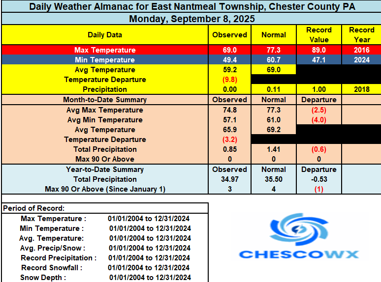
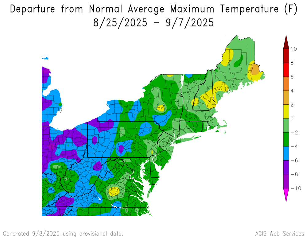
Widespread low temperatures again in the 40’s across much of the county. The lowest was our normal cold spot at Warwick Township at 42.7 degrees . If you think we have been experiencing a chilly stretch you are correct. Yesterday here in East Nantmeal was our 20th below normal temperature day over the last 22 days. We continue this below normal trend for the next couple of days before we may see near to slightly above normal temperatures by this weekend before slipping back to a little below normal by next week. No rain at all in the forecast for the next week.
-
(002).thumb.png.6e3d9d46bca5fe41aab7a74871dd8af8.png)
E PA/NJ/DE Autumn 2025 Obs/Discussion
ChescoWx replied to PhiEaglesfan712's topic in Philadelphia Region
Widespread low temperatures again in the 40’s across much of the county. The lowest was our normal cold spot at Warwick Township at 42.7 degrees . If you think we have been experiencing a chilly stretch you are correct. Yesterday here in East Nantmeal was our 20th below normal temperature day over the last 22 days. We continue this below normal trend for the next couple of days before we may see near to slightly above normal temperatures by this weekend before slipping back to a little below normal by next week. No rain at all in the forecast for the next week.
-
Not a Bears fan but read somewhere this morning that when he is pressured and starts to run, he doesn't look like he has control of his arms and legs. Just complete panic and I kinda laughed thinking back at watching it, lol. Commanders are so lucky JD5 was there at 2.
-
Autumn* we don’t have winter anymore
-
Mins A sneaky 34° there for 1P1
-

September 2025 OBS-Discussion centered NYC subforum
uofmiami replied to wdrag's topic in New York City Metro
48.6 in Muttontown & 50.6 in Syosset this morning. -
40.4 low, just missed getting into the 30's. Clear skies, outstanding weather! Not a record, that stands from last year at 39.5 degrees.
-
Hoping that continues for sure. Hopefully we get a few more recurving typhoons to keep that water off Japan cooling down.
-

September 2025 OBS-Discussion centered NYC subforum
jm1220 replied to wdrag's topic in New York City Metro
Down to 50 here. -
The gfs is mainly the rainy one. My point and click has rain all next week. It looks like it depends on a tropical low to our SE.
-
43 degrees this morning. Appears the hummingbirds are gone for the year.
-
Low of 50.6. Coldest morning so far
-

September 2025 OBS-Discussion centered NYC subforum
lee59 replied to wdrag's topic in New York City Metro
53 here this morning, plenty of 30s in the Catskills area. The coldest I saw is 30 degrees in Saranac Lake NY. - Today
-
For some reason I wasn't upset at how the game started for the Vikings i just figured JJ was so new it is going to take time. The defense was solid and with the score still close i started to think some guys just win even when its ugly. Once the momentum shifted i knew it was on. Who knows how the rest of the season goes but 1-0 is better than 0-1. Caleb Williams has talent but I don't think he's him.
-
It's getting thin
-
Another beautiful morning with a current temp of 45 degrees. Should be a beautiful day on tap.
-

September 2025 OBS-Discussion centered NYC subforum
bluewave replied to wdrag's topic in New York City Metro
Dry conditions snd high pressure really allowing the radiational cooling to overperform during recent weeks. So the low temperature departures have been more impressive. Also helps the high temperatures beat guidance at times.
-
Thanks… I guess???
-
This is also a general winter and seasonal forecast thread. My post about DC snowfall was only introduced when a poster asked me about it. You even liked the post. The way any ENSO state is being expressed in our sensible weather has been heavily influenced by the sudden jump in SSTs and global temperatures. So the WPAC warm pool along with other basins has been becoming a greater factor at times than ENSO. We saw this many times in recent years when El Niños in 18-19, 19-20, and 23-24 were heavily influenced by events in the WPAC and IO. So just looking at a one dimensional slice of ENSO east of the Dateline has become less relevant than it used to be. The first two winters couldn’t couple and we got more of a Niña background state. 23-24 had unusually strong WPAC and IO forcing with the record SSTs there and the typical El Niño cold trough in the East wasn’t able to develop. This past winter there was talk of a 13-14 analog. But the Pacific Jet was much stronger so places like Chicago had one of their least snowy winters instead of a 13-14 outcome. Plus the 850 mb cold pool was the smallest on record for the Northern Hemisphere preventing the cold trough formation in the Great Lakes like 13-14.
-
I don’t see that for next week (the rainy party at least), but rain chance for tomorrow has popped up fast. Seems like someone will get some rain that rotates in from the low offshore. But a huge variation on where that happens. NAM deluges VA, Hrrr pushes it into NJ mostly. Euro targets the metro areas, but with light rain.
-
You seem to have an abundance of bl on your lot.
-
Congrats Alex on the freeze…30.7 HIE 31 LPD 32 SLK 29 Thankfully only 43.0 here
-

Central PA Summer 2025
Mount Joy Snowman replied to Voyager's topic in Upstate New York/Pennsylvania
48 when I left the house. Crisp. -
After a nice cool start to September, looks like we get to normal in a couple days and then above normal for a while. Below normal rainfall. .


