All Activity
- Past hour
-

E PA/NJ/DE Autumn 2026 Obs/Discussion
Hurricane Agnes replied to PhiEaglesfan712's topic in Philadelphia Region
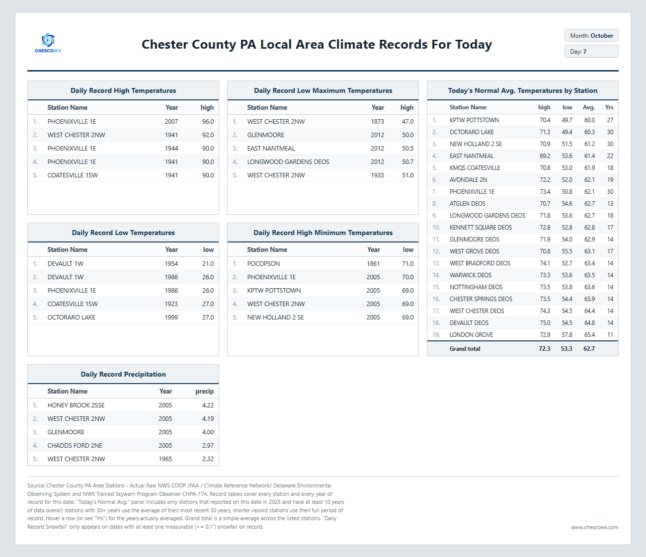
Was 42 here this morning! Big high, clear skies, wind went calm overnight = efficient radiational cooling. And now there is Isaias (2) that might throw some moisture this way with any fronts. Isaias (1) from 2020 - https://www.weather.gov/phi/EventReview20200804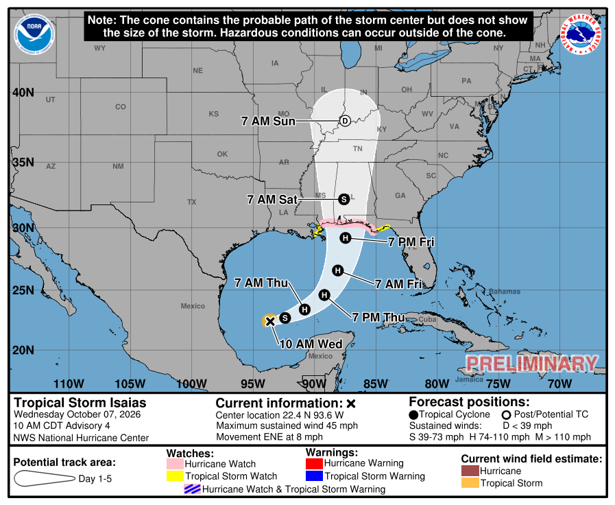
-
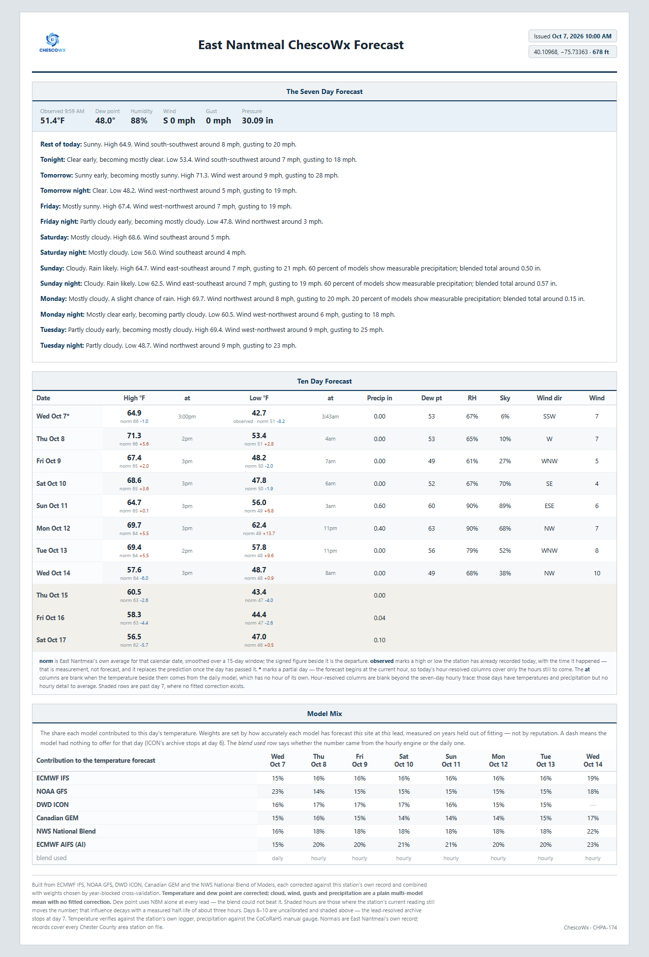
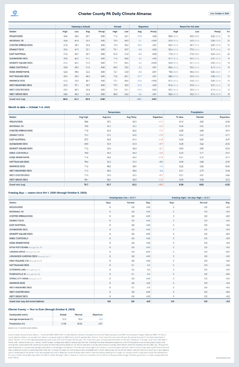
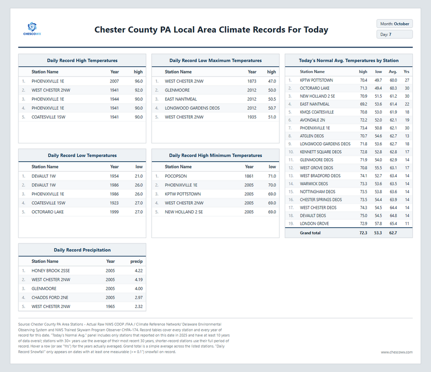
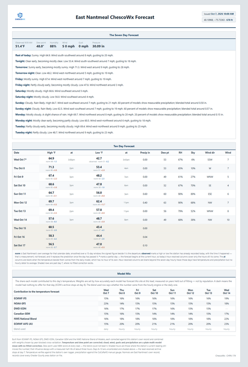
Our great stretch of autumnal weather continues through Saturday. Temperatures will stay below normal today before rising to near to slightly above normal tomorrow and Saturday. Rain chances ramp up with the tropical storm remnants by Sunday into Monday. We look to turn sharply cooler around the middle of the month.
-
(002).thumb.png.6e3d9d46bca5fe41aab7a74871dd8af8.png)
E PA/NJ/DE Autumn 2026 Obs/Discussion
ChescoWx replied to PhiEaglesfan712's topic in Philadelphia Region
Our great stretch of autumnal weather continues through Saturday. Temperatures will stay below normal today before rising to near to slightly above normal tomorrow and Saturday. Rain chances ramp up with the tropical storm remnants by Sunday into Monday. We look to turn sharply cooler around the middle of the month.
-
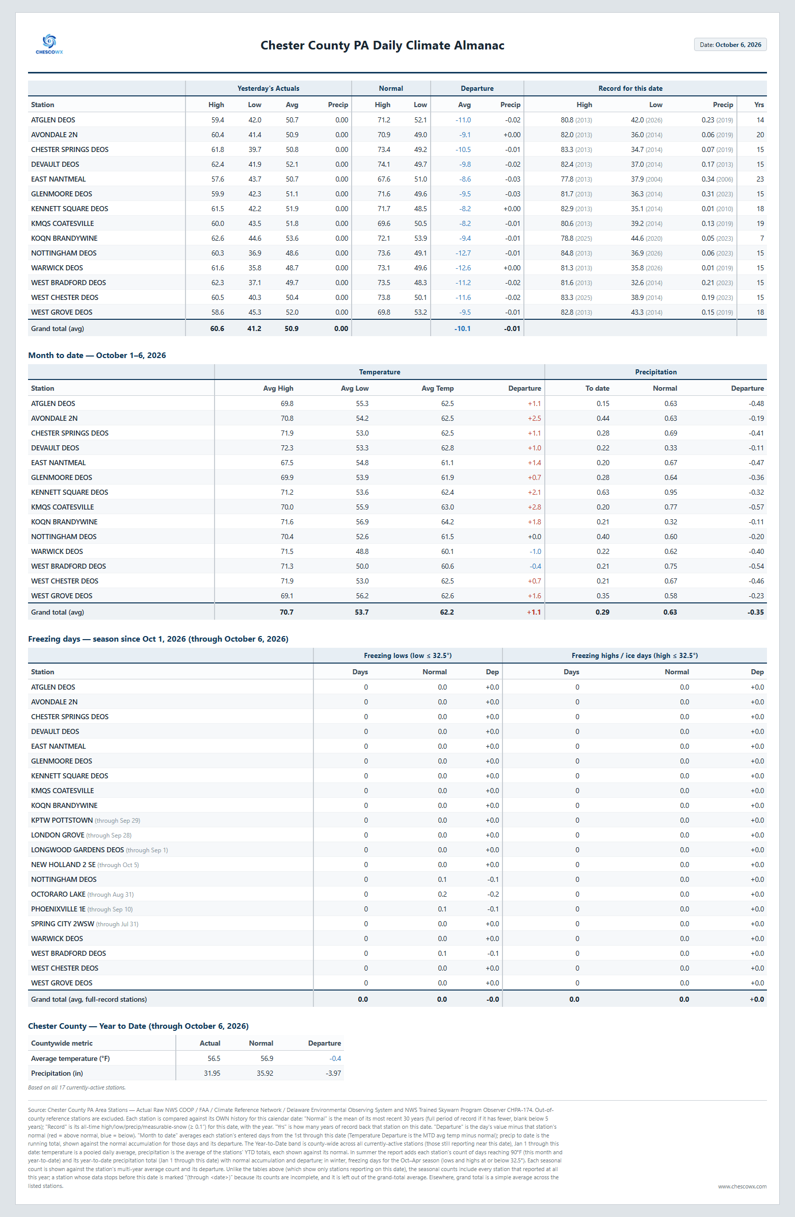
36 was the low here. No frost IMBY.
-
E9
-
Low temp of 38 here. Heat went on.
-

-
Tropical Storm Isaias Discussion Number 4 NWS National Hurricane Center Miami FL AL092026 1000 AM CDT Wed Oct 07 2026 Isaias has gotten better organized during the past several hours with a large area of deep convection near and northeast of the center. Recent Air Force Hurricane Hunter data indicate that the center is re-forming a bit to the north of the previous advisory nearer to the mid-level center, with an estimated pressure of 1000 mb derived from dropsonde data. The initial wind speed is set to 40 kt in consideration of increase in satellite organization and the 4-mb dropsonde pressure fall, close to the UW-CIMSS SATCON values and many of the other objective estimates. The storm is moving east-northeast at 7 kt. The motion should gradually bend northward and increase during the next few days as a trough along the northwestern Gulf coast amplifies and the subtropical ridge east of Florida builds westward. This pattern should cause a fast-moving Isaias to approach the northern Gulf coast by Friday afternoon. Model guidance continues to be somewhat split, with the AI-based models generally on the right side of the model envelope, and the physics based models on the left side. The new NHC forecast is nudged a bit eastward, but isn't as far east as the latest HFIP Corrected Consensus Approach (HCCA) or Google DeepMind ensemble mean (GDMI). It is worth noting that many of the stronger solutions tend to be on the eastern half of the guidance and faster, which necessitates a variety of watches at this time. With the center re-formation, the low- and mid-level centers appear to be coming into better alignment. This structural change could facilitate rapid intensification during the next day or two given light-to-moderate shear along the forecast track, near-record SSTs for this time of the year and a very moist environment. Near landfall, increasing shear could cause some weakening, but it isn't certain how fast the winds will diminish. Regardless, Isaias should be growing in size as it approaches the northern Gulf coast due to a trough interaction. The latest guidance is very close to the last NHC intensity forecast, so little changes were made, and the NHC prediction is just below the corrected-consensus HCCA. Key Messages: 1. Isaias is expected to strengthen into a strong hurricane before approaching the northern Gulf Coast on Friday. There is an increasing risk of life-threatening storm surge along portions of the northern Gulf coast, and a Storm Surge Watch has been issued from The Mouth of the Mississippi River to Yankeetown Florida. Residents in the watch area should follow advice given by local officials and evacuate if told to do so. 2. The risk of damaging hurricane force-winds is increasing over portions of the Florida Panhandle, southern Alabama, and Mississippi. A Hurricane Watch has been issued from Bay St. Louis, Mississippi, to Indian Pass, Florida. Residents in these areas should prepare for the possibility of long-duration power outages. 3. Isaias will bring areas of heavy rainfall to the central U.S. Gulf coast and much of the Southeast Friday into the weekend. Flash and urban flooding, along with isolated river flooding, will be possible. 4. Isaias could bring gusty winds and areas of heavy rain to the western portion of the Yucatan Peninsula over the next day or so. FORECAST POSITIONS AND MAX WINDS INIT 07/1500Z 22.4N 93.6W 40 KT 45 MPH 12H 08/0000Z 22.7N 92.4W 50 KT 60 MPH 24H 08/1200Z 23.4N 90.8W 65 KT 75 MPH 36H 09/0000Z 24.6N 89.2W 80 KT 90 MPH 48H 09/1200Z 26.6N 88.1W 95 KT 110 MPH 60H 10/0000Z 29.2N 87.5W 90 KT 105 MPH 72H 10/1200Z 32.2N 87.6W 45 KT 50 MPH...INLAND 96H 11/1200Z 38.0N 87.5W 20 KT 25 MPH...POST-TROP/INLAND 120H 12/1200Z...DISSIPATED $$ Forecaster Blake
-
Back in Charlottesville. Got to 43 degrees for the low and was around 62 degrees when biking to Grounds. Perfect fall morning weather. Sat outside for a bit before class just to soak it in.
-
I was thinking the same thing as the track moved East this morning. I'm in NGA and after how cool its been, and knowing tropical moisture is heading this way....sounds like the perfect setup for a southeastern tornado event. We're watching closely, especially after the last few "weaker" systems that came through here over the last few years permanently altered the landscape.
-

Mountain West Discussion
mayjawintastawm replied to mayjawintastawm's topic in Central/Western States
Yeah, pretty weird that we have not had a sub-45 F temp at my house. Was walking the dog at 10:30 last night in shorts. Typically our first hard freeze is this week. Also can vouch for Chinook's pictures as representative of the mountains in CO generally- flew from SW to NE yesterday, right over BV, and snow levels were between 12 and 13K feet and nothing deep enough to be consequential. Basically nothing on south facing slopes. A good month behind. -
-

2026-2027 Record-breaking El Nino
GaWx replied to Stormchaserchuck1's topic in Weather Forecasting and Discussion
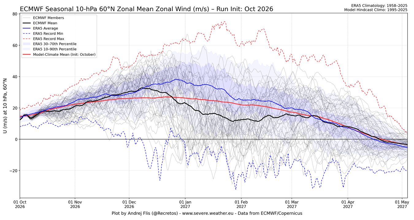
Thanks. But with ERA5 not being a prognosis, why is its blue line going all of the way til 5/1/27? -
BULLETIN Tropical Storm Isaias Advisory Number 4 NWS National Hurricane Center Miami FL AL092026 1000 AM CDT Wed Oct 07 2026 ...HURRICANE AND STORM SURGE WATCHES ISSUED FOR PORTIONS OF THE NORTHERN GULF COAST FOR STRENGTHENING ISAIAS... SUMMARY OF 1000 AM CDT...1500 UTC...INFORMATION ----------------------------------------------- LOCATION...22.4N 93.6W ABOUT 260 MI...420 KM WNW OF PROGRESO MEXICO ABOUT 540 MI...870 KM SSW OF THE MOUTH OF THE MISSISSIPPI RIVER MAXIMUM SUSTAINED WINDS...45 MPH...75 KM/H PRESENT MOVEMENT...ENE OR 70 DEGREES AT 8 MPH...13 KM/H MINIMUM CENTRAL PRESSURE...1000 MB...29.53 INCHES WATCHES AND WARNINGS -------------------- CHANGES WITH THIS ADVISORY: A Storm Surge Watch has been issued from the Mouth of the Mississippi River eastward to Yankeetown, Florida. A Hurricane Watch has been issued for the northern Gulf Coast from Bay St. Louis, Mississippi to Indian Pass, Florida. A Tropical Storm Watch has been issued for the northern Gulf Coast from the Jefferson/Plaquemines Parish line, Louisiana to west of Bay St. Louis, and from east of Indian Pass to Aucilla River, Florida. SUMMARY OF WATCHES AND WARNINGS IN EFFECT: A Storm Surge Watch is in effect for... * Mouth of the Mississippi River to Yankeetown A Hurricane Watch is in effect for... * Bay St. Louis to Indian Pass A Tropical Storm Watch is in effect for... * Jefferson/Plaquemines Parish line to west of Bay St. Louis * East of Indian Pass to Aucilla River
-

2026-2027 Record-breaking El Nino
LakePaste25 replied to Stormchaserchuck1's topic in Weather Forecasting and Discussion
ERA5 is not a prognosis, it’s a reanalysis of the daily mean averaged out over several decades (i think it starts 1940 but someone can correct me here). The black is the actual forecast ensemble mean. So it’s currently forecast to go below the historical mean. -
Posted by Brad P a little while Ago. .
-
It's a silly semantic thing. Probably. altho, some may think it actually means something. If the charts look like a low or 41, yet it bottoms 31 at climo holes and the like, those results are disassociated local feedbacks that don't represent the qualitative state of the whole. ... interpreted as "it's not 'posed to be that cold" -almost imagine a tone there that something's unfair. ha Radiational cooling is modified by local feedback phenomenon. But the nature of what that does/is, it is disassociated from the larger expectation - the latter being some combination/weighted seasonality vs synoptics. A product that is evinced by the fact that here we are at 11am and it's 57 unilaterally even where it was 31 - an example. Objective reality: it is both 31 and cold, while being in a 41 suggested holistic synoptic state. Both are true. Nothing else. There is no "fake cold" Nothing novel about this ...it's just the shenanigans of public noise - shimmering with intelligence as it does
-

Winter 2026-2027 Speculation
Prismshine Productions replied to 40/70 Benchmark's topic in New England
Doing a bit of math here... Last month was at -5.5", converting that new map to inches and adding... Well, shit, -1.5" Sent from my SM-S176V using Tapatalk -
low grade remnant showers looking increasingly likely for some of us
-
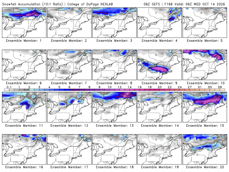
Yeah me and a buddy were going to that game and watched the snow instead from our balcony . About 1.5” in Beltsville with huge amounts out in Skyline
-
Car batteries know that it's real, but only in the lower levels - go up 100 yards and the temp would be significantly higher. When we lived on sloping ground at 970' asl in the back settlement of Fort Kent, after calm clear overnights we'd see the smoke layer above the sawmill cone burner across the St. John and would know that it was 10°+ colder than our place at the riverside office. It's a similar "fake" when growing season transpiration brings tall TDs - in each case the extreme conditions aren't the same as the overall airmass. Temp had dropped into the upper 30s by 10 PM last night, so I expected mid-upper 20s. Maybe the wind returned, as our low was 33.
-
it's a badge of honor thing to some to see how late they can go without flipping the heat on. Kinda weird but whatever floats your boat
-
2026-2027 Record-breaking El Nino
GaWx replied to Stormchaserchuck1's topic in Weather Forecasting and Discussion
Any comments about what this graph implies? Why is prog of ERA5 avg (blue) so much higher than prog of ECMWF mean (black)? Isn’t ERA5 produced by ECMWF? Is ERA5 its own projection model? Any explanation would be appreciated.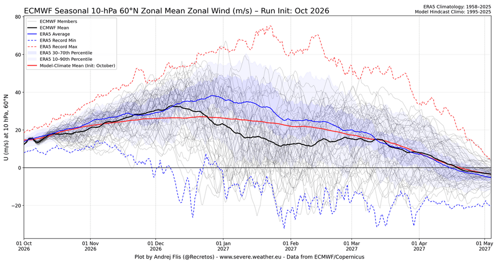
-
We are going to be very good this winter. 2002-03 keeps showing up. That means the general pattern more than one huge storm but such storm is not discounted I also look at first half of October as to how far off NWS and others are in predicting below average temps in the 5+ day prior to. This cool shot prediction had DC in upper 50’s for highs initially which verified more like 63-64 so about 5/6 degrees off .
-
it's amazing how the universe finds a way to get to entropy. like ...keep using oil, the temp rises to the point where you don't need to use any oil. problem solved. lol