All Activity
- Past hour
-
Ugh. How is this not getting more backlash? Seems to be a pretty big deal to me.
-
This Aug 1871 hurricane made landfall on the Big Island as an estimated Cat 3. Details analysis here: https://journals.ametsoc.org/view/journals/bams/99/1/bams-d-16-0333.1.xml
-
2 inches more than me. Of course the drought monitor says it has lessened.
-

2026-2027 Record-breaking El Nino
40/70 Benchmark replied to Stormchaserchuck1's topic in Weather Forecasting and Discussion
That JMA output is textbook Modoki composite. Again, I think that is overdone in the seasonal mean, but it is what it is. -
I sense we're incrementally inching closer, year by year, to the 'winter it didn't snow' Up N that's more likely just a shockingly low season total, but ranging to a phatty 0 at LGA and Logan. ORH got 1.5" of glop on January 7th and white pawed their way to more climate denial excuses. Sardonic aside, eventually that does have to happen. It'll be once ...then 5 years goes by, a span that host so-so's and one winter that is phenomenal, as much for snow as it will be enabling. Then, it happens again so soon? huh. Eventually ... they're happening more frequently and viola, "we're not Va Beach" This is a toad in the pan thing -
-

Invest 92L--80% two day, 80% five day odds
WxWatcher007 replied to WxWatcher007's topic in Tropical Headquarters
Pretty good chance we get TC genesis here. Gradual organization continuing. -
Wouldn't want to experience the damage the hail of this size creates. Thanks for posting!
-
Now that the follow up wave in the Tropical Atlantic has been designated as Invest 94L and has a decent chance of development, I'm breaking out discussion into a new thread. Eastern Tropical Atlantic (AL94): A tropical wave located a few hundred miles south-southwest of the Cabo Verde Islands is producing disorganized showers and thunderstorms. Environmental conditions are forecast to be generally conducive for gradual development, and a tropical depression could form late this week or this weekend while the wave moves westward or west-northwestward across the eastern and central tropical Atlantic. * Formation chance through 48 hours...low...30 percent. * Formation chance through 7 days...medium...50 percent.
-
Had nice storm around 2am. Got 1/4" of rain. Warm out but a cool breeze making things tolerable.
-

Augdewst 2026: Summer's Last Stand
weatherwiz replied to Prismshine Productions's topic in New England
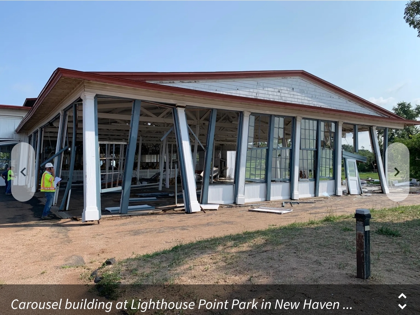
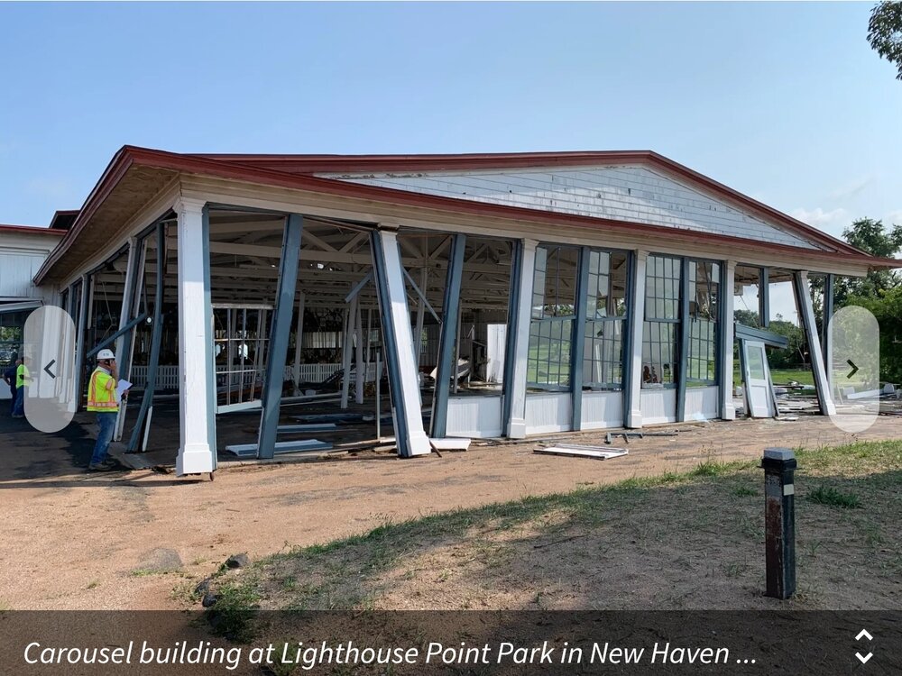
I am really starting to wonder if a brief tornado touchdown between Milford/Orange and then touched down again around Lighthouse Point. We'll have to see if the NWS sends out anyone to survey. -
Very localized. Only damage seems to be Lighthouse point and the area that says woodmont on your radar screenshot.
-
Hyped to see how the train ends up later, was "worried" about a near total shut out but from my model hawking it looks like the action may at least start as far north as 88ish. On the one hand, rooting for IYBY inundation is a special kind of masochism for obvious reasons, especially with flash flooding being a proven concern for my building's parking lot. But I also can't recall the last time I personally experienced the sort of train where the ~GV+ genuinely just keeps rolling through overhead for hours. At least I don't have a basement to worry about...
-

2026-2027 Record-breaking El Nino
MJO812 replied to Stormchaserchuck1's topic in Weather Forecasting and Discussion
Nice western ridge -
Looks like the carousel building took a direct hit. https://www.wtnh.com/news/connecticut/new-haven/lighthouse-point-park-in-new-haven-closed-due-to-storm-damage/
-
Augdewst 2026: Summer's Last Stand
WxWatcher007 replied to Prismshine Productions's topic in New England
Just leaving this here…congrats Hawaii. -
There was one winter recently that JB went warm and snowless. That was a sign you knew something bad was coming because not even JB could find a path to victory.
-
Augdewst 2026: Summer's Last Stand
weatherwiz replied to Prismshine Productions's topic in New England
Looking through at mesoanalysis last night and there is nothing really jumping out. There had to have been some sort of mesoscale or microscale interaction to really enhance things. But this is really nuts...80-100+ mph straight-lines is not easy to accomplish, especially here and especially at night. - Today
-
August 13 1964: Minnesota receives a taste of fall, with lows of 26 in Bigfork and 30 in Campbell. For Thursday, August 13, 2026 1831 - The Great Barbados Hurricane was an intense Category 4 hurricane that left cataclysmic damage across the Caribbean and Louisiana in 1831. From August 11 through the 13, Bermudians were amazed to see the sun with a decidedly blue appearance, giving off an eerie blue light when it shone into rooms and other enclosed places. Ships at sea as far west as Cape Hatteras reported that "their white sails appeared a light blue colour." A month later it was learned that the astounding blue sunlight had coincided with a terrible hurricane that caused 1,477 people to lose their lives. It was assumed that the hurricane was intensive enough to cause an unusual disturbance in the higher atmospheric strata, and refraction, diffraction or absorption of light rays, to produce the blue reflection. Because the sun appeared bluish-green, Nat Turner took this as the final signal and began a slave rebellion a week later on August 21. 1919 - High winds and heavy rain struck the Middle Atlantic Coast Region. In New Jersey, winds gusted to 60 mph at Atlantic City, and nine inches of rain fell at Tuckerton. The wind and rain leveled crops and stripped trees of fruit causing several million dollars damage. (David Ludlum) 1980 - The afternoon high at New York City was just 89 degrees. But there were fifteen days of 90 degree heat during the month, their hottest August of record. (The Weather Channel) 1985 - Hail larger than golf balls, driven by 70 mph winds, moved down crops, stripped trees, and broke windows, near Logan KS. Road graders cleared three foot drifts of hail on Kansas Highway 9 east of Logan. (The Weather Channel) 1987 - Thunderstorms deluged the Central Gulf Coast States with torrential rains. Thunderstorms in Mississippi drenched Marion County with up to 15 inches of rain during the morning hours, with 12.2 inches reported at Columbia. Floodwaters swept cars away in the Lakeview subdivision of Columbia when the the Lakeview Dam broke. Flash flooding caused more than three million dollars damage in Marion County. (The National Weather Summary) (Storm Data) 1988 - A dozen cities in the northeastern U.S. reported record high temperatures for the date. Lansing MI reported a record 35 days of 90 degree weather for the year, Detroit MI reported a record 37 days of 90 degree heat for the year, and Williamsport PA reported a record 38 days of 90 degree weather for the year. (The National Weather Summary) 1989 - Thunderstorms developing in a tropical airmass over the northeastern U.S. soaked Connecticut and Massachusetts with four to eight inches of rain over the weekend, between the 11th and 13th of the month. Hartford CT received 7.70 inches of rain. (The National Weather Summary) (Storm Data) 1991 - Stockton, California received 0.05 inch of rainfall on this day. Since 1949, this is the only measured rainfall in Stockton on August 13th. 2014 - An official, New York State 24 hour precipitation record was set at Islip, NY on August 12-13 when 13.57" of rain fell. Observances: 13 Thu Left-Handers Day 13 Thu National Filet Mignon Day 13 Thu National Prosecco Day 13 Thu Women's and Family Day
-
You reminded me of something. Whenever I was far away from home when I was younger, when I drove back, the first thing I noticed was the change in the smell of the air. Literally could smell the freshness of the Lakes the closer you got. You take that for granted living next to them all the time.
-
I'm seeing a lot of drum banging about the Euro seasonal throwing out a lot of +PNA/-NAO looks. AKA the holy grail for snow lovers.
-
Surprised he said slightly, lol
-
-
 Trust Pharma India: online shopping pharmacy india - online pharmacy india
 -
(002).thumb.png.6e3d9d46bca5fe41aab7a74871dd8af8.png)
Central PA Summer 2026 Discussion/Obs Thread
ChescoWx replied to Voyager's topic in Upstate New York/Pennsylvania
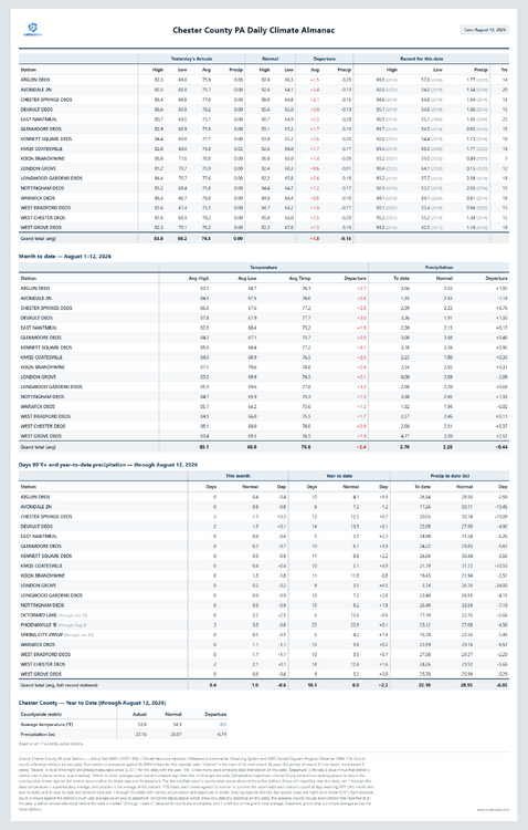
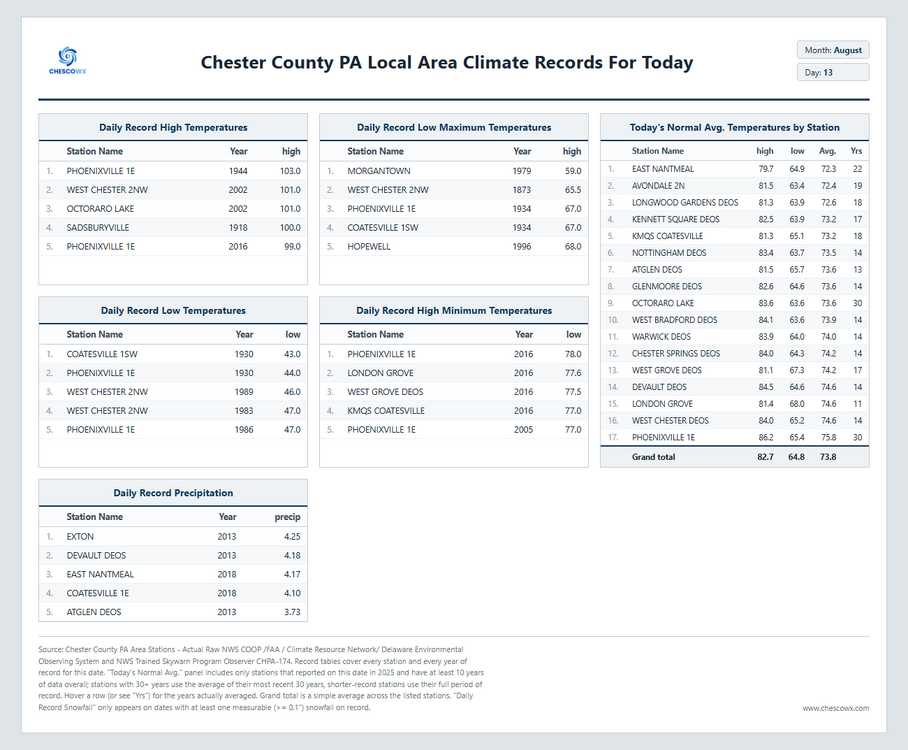
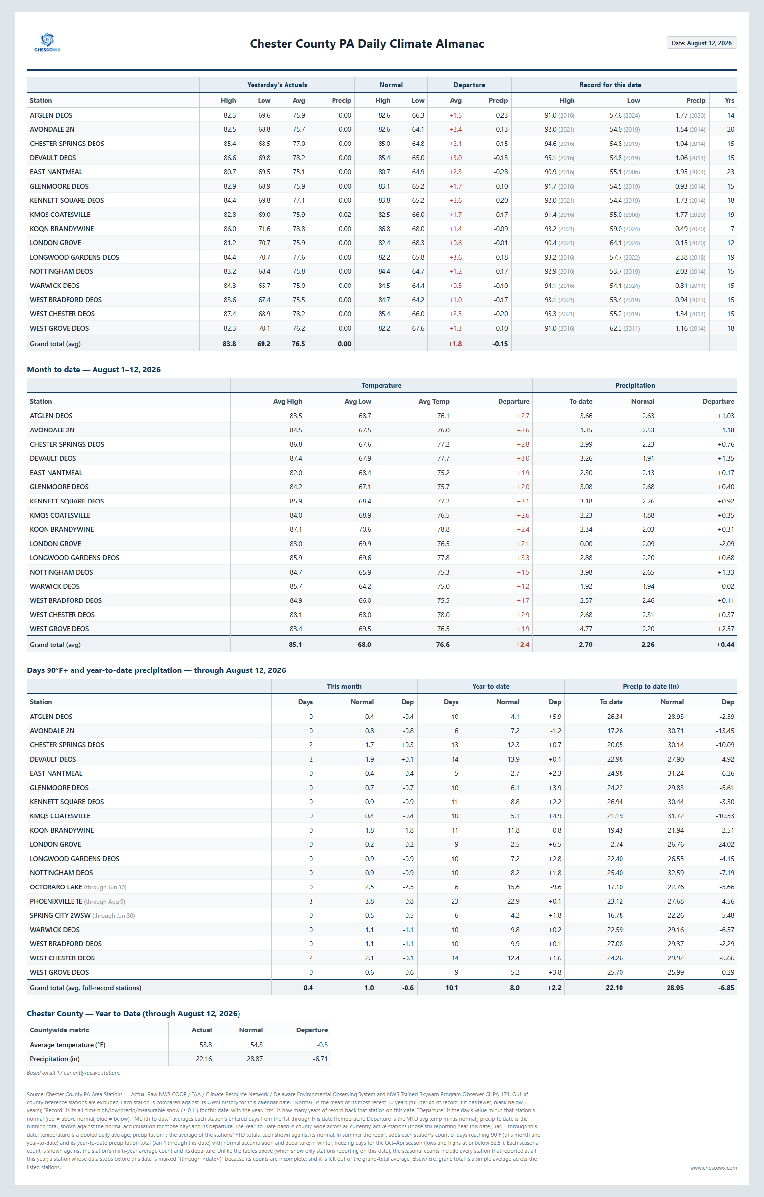
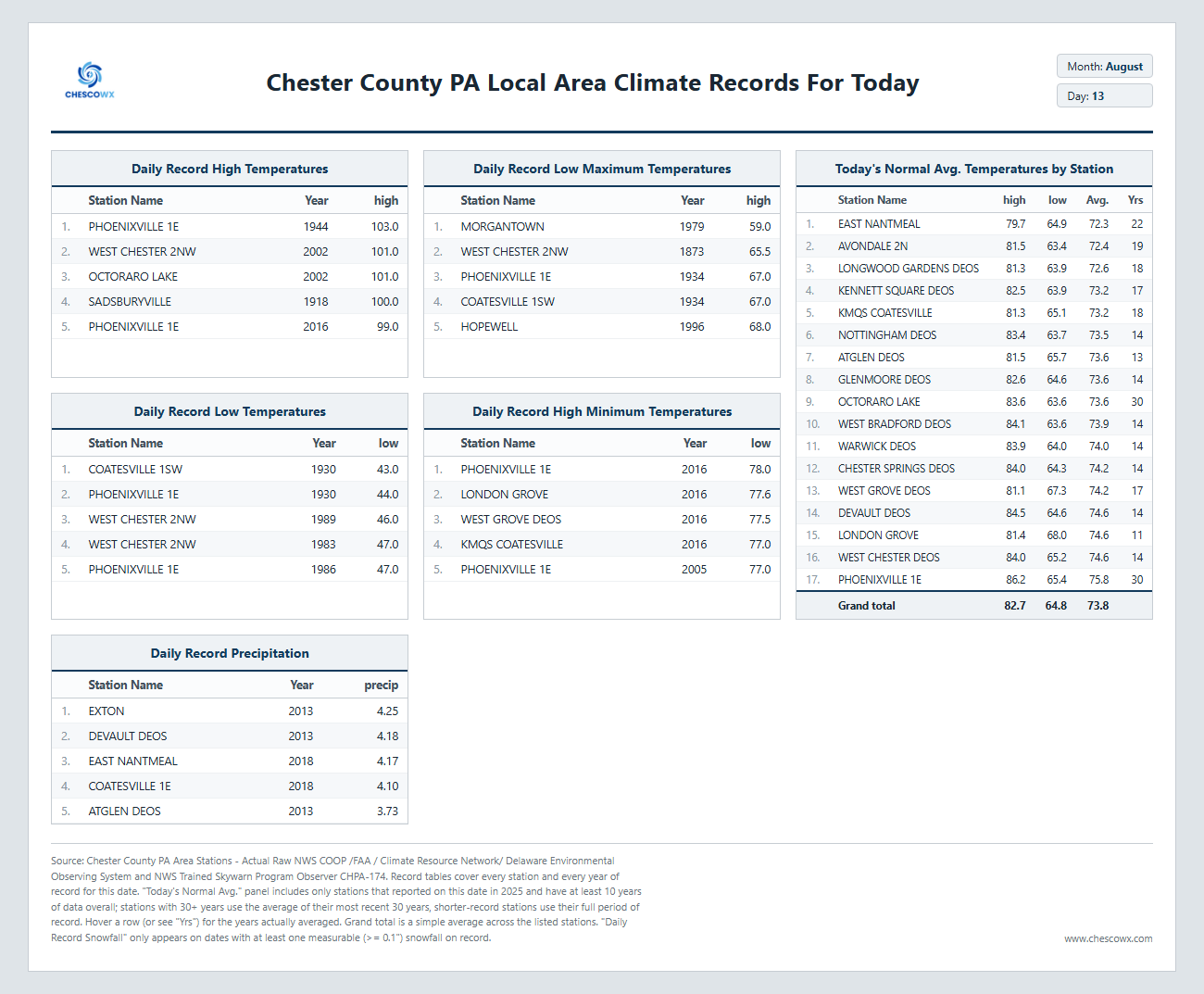
Today will be our last day with higher humidity. We should cooler weather both tomorrow and especially on Saturday. However, we turn more humid and wetter again by later Sunday into Monday. Drier and near normal temperatures arrive by next Tuesday.